
Lawngtlai (District)
| Lawngtlai District | |
|---|---|

|
|
| State | Mizoram |
| Administrative headquarters : | Lawngtlai |
| Area : | 2557 km² |
| Residents : | 117,894 (2011) |
| Population density : | 46 inhabitants / km² |
| Website : | www.lawngtlai.nic.in |
The Lawngtlai district is a district in the Indian state of Mizoram . The administrative seat is the city of the same name Lawngtlai .
geography
The Lawngtlai district is located in the south of Mizoram on the border with Bangladesh and Myanmar . The area of the district is 2557 square kilometers. Neighboring districts are Lunglei in the north and Saiha in the east. The district borders Myanmar to the south and Bangladesh to the west.
history
In the late 19th century, the British conquered the region and the area became part of Assam. During World War II, the area was near the front line between the British and Japanese. After Indian independence, Assam joined India in 1949. Later Assam was split up into several states and the area became part of the new state of Mizoram. The district originally belonged to the Mizo district . In 1976 this was split into the three new districts of Aizawl, Chhimtuipui and Lunglei. Lawngtlai was part of the Chhimtuipui District. In 1998, the then Chhimtuipui district was split into the new Lawngtlai and Saiha districts. The territorial status has remained unchanged since then.
population
According to the 2011 census, the Lawngtlai district has 117,894 inhabitants. With 46 inhabitants per square kilometer, the district is only sparsely populated. The district is predominantly rural. Of the 117,894 residents, 97,064 people (82.33%) live in rural areas and 20,830 people in urban communities.
The Lawngtlai district is one of those areas of India that are almost entirely populated by members of the "tribal population" ( scheduled tribes ). Among them were (2011) 112,354 people (95.30 percent of the district population). The Dalit ( scheduled castes ) numbered only 146 people in 2011 (0.10 percent of the district's population).
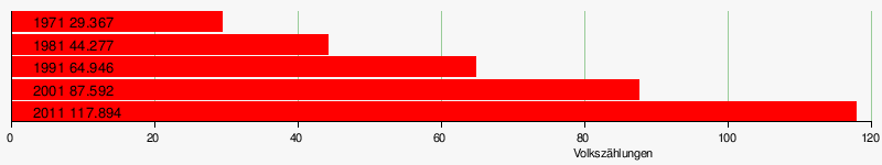
Population development
As everywhere in India, the population in the Lawngtlai district has been growing rapidly for decades. The increase in the years 2001-2011 was almost 35 percent (34.59%). In these ten years the population increased by over 30,000 people. The following table illustrates the development:
Significant places
With the district capital Lawngtlai (20,830 inhabitants) there is only one place with more than 10,000 inhabitants in the district.
District population by gender
As is common in India, the district always had more male than female residents. Between 1971 and 1981 the proportion of men increased sharply. But in recent years the surplus of men has been falling again. Among the youngest residents (under 7 years of age) the proportions of both sexes are 50.85% male and 49.15% female.
| Distribution of population by gender in Lawngtlai district | ||||||||||||||
| 1971 census | 1981 census | 1991 census | 2001 census | 2011 census | ||||||||||
| number | proportion of | number | proportion of | number | proportion of | number | proportion of | number | proportion of | |||||
| TOTAL | 29,367 | 100% | 44,277 | 100% | 64,946 | 100% | 87,592 | 100% | 117,894 | 100% | ||||
| Men | 14,887 | 50.69% | 23,539 | 53.16% | 34,171 | 52.61% | 45,877 | 52.37% | 60,599 | 51.40% | ||||
| Women | 14,480 | 49.31% | 20,738 | 46.84% | 30,775 | 47.39% | 41,715 | 47.63% | 57,295 | 48.60% | ||||
District population by language
The Lawngtlai district's population is linguistically very mixed. In contrast to other regions of the state of Mizoram, no ethnic group dominates here. The strongest three language groups Chakma, Pawi and Mizo / Lushai still belong to around 80 percent of the population. In the RD Block Chawngte, 37,803 people (83.44 percent of the residents) are Chakma. In the RD Block Lawngtlai, 17,798 people (45.96 percent of the residents) are Mizo / Lushai and 8,952 people (23.12 percent of the residents) are Pawi. In the RD Block Sangau, 15,719 people (93.91 percent of the residents) are Pawi. And in the RD Block South Bungtlang 5,772 people (33.70 percent of the residents) are Chakma, 3,503 people (20.45 percent of the residents) Mizo / Lushai, 2,261 people (13.20 percent of the residents) Kokborok and 1,844 people (10, 76 percent of residents) Riang. All languages spoken by more than 500 people are shown in the following table:
| year | Chakma | Pawi | Lushai | Riang | Kokborok | Bengali | Hindi | Total | ||||||||
|---|---|---|---|---|---|---|---|---|---|---|---|---|---|---|---|---|
| number | % | number | % | number | % | number | % | number | % | number | % | number | % | number | % | |
| 2011 | 46,309 | 39.28 | 24,710 | 20.96 | 23.096 | 19.59 | 5,780 | 4.90 | 2,730 | 2.32 | 789 | 0.67 | 606 | 0.51 | 117,894 | 100.00% |
| Source: 2011 census result | ||||||||||||||||
Population of the district by confession
The Tibetan Burmese residents have converted almost entirely to Christianity in the past 100 years. The most important communities within Christianity are the Presbyterians (Reformed), Baptists, and Catholics. The Chakma, on the other hand, are more than 90 percent Buddhists like the residents of nearby Myanmar. The Hindus and Muslims form smaller religious minorities and are mainly immigrants from other regions of India and from Bangladesh. The following table shows the exact religious composition of the population:
| year | Buddhists | Christians | Hindus | Jainas | Muslims | Sikhs | Other | not specified | Total | |||||||||
|---|---|---|---|---|---|---|---|---|---|---|---|---|---|---|---|---|---|---|
| number | % | number | % | number | % | number | % | number | % | number | % | number | % | number | % | number | % | |
| 2011 | 51,549 | 43.72 | 63,892 | 54.19 | 1,668 | 1.41 | 122 | 0.10 | 522 | 0.44 | 52 | 0.04 | 2 | 0.00 | 87 | 0.07 | 117,894 | 100.00% |
| Source: 2011 census result | ||||||||||||||||||
education
Thanks to significant efforts, the goal of full literacy in urban areas has almost been achieved. In rural areas, only around 60 percent can read and write. The strong differences between the sexes and the urban / rural population are typical of Indian conditions. Literacy is well below the Mizoram average.
| Literacy in Lawngtlai District | ||||||
| unit | 2011 census | |||||
| number | proportion of | |||||
| TOTAL | 62,861 | 65.88% | ||||
| Men | 36,444 | 74.12% | ||||
| Women | 26,417 | 57.12% | ||||
| TOTAL CITY | 16,939 | 95.66% | ||||
| City men | 8,800 | 96.97% | ||||
| City women | 8,139 | 94.28% | ||||
| TOTAL COUNTRY | 45,922 | 59.10% | ||||
| Country men | 27,644 | 68.95% | ||||
| Country women | 18,278 | 48.60% | ||||
| Source: 2011 census result | ||||||
administration
The district was divided into four sub-divisions (CD blocks) at the last census in 2011:
| Population in the sub-divisions | ||||||||
| Chawngte | Lawngtlai | Sangau | South Bungtlang | |||||
| number | proportion of | number | proportion of | number | proportion of | number | proportion of | |
| TOTAL | 45,307 | 100% | 38,722 | 100% | 16,739 | 100% | 17.126 | 100% |
| Men | 23,457 | 51.77% | 19,857 | 51.28% | 8,438 | 50.41% | 8,847 | 51.66% |
| Women | 21,850 | 48.23% | 18,865 | 48.72% | 8,301 | 49.59% | 8,279 | 48.34% |
| city | 0 | 0% | 20,830 | 53.79% | 0 | 0% | 0 | 0% |
| country | 45,307 | 100% | 17,892 | 46.21% | 16,739 | 100% | 17.126 | 100% |
Individual evidence
- ↑ Lawngtlai District: Census 2011 data
- ↑ A - 2 DECADAL VARIATION IN POPULATION SINCE 1901
- ^ Result of the 2011 census on city population
- ↑ District Census Handbook Lawngtlai
Web links

Coordinates: 24 ° 19 ′ 12 ″ N , 92 ° 32 ′ 24 ″ E