
Serchhip (district)
| Serchhip District | |
|---|---|

|
|
| State | Mizoram |
| Administrative headquarters : | Serchhip |
| Area : | 1410 km² |
| Residents : | 64,937 (2011) |
| Population density : | 46 inhabitants / km² |
| Website : | official website |
The Serchhip district is a district in the Indian state of Mizoram . The administrative seat is the place of the same name Serchhip .
geography
The Serchhip district is located in the middle of Mizoram on the border with Myanmar . The area of the district is 1410 square kilometers. Neighboring districts are Aizawl District in the north, Champhai District in the east, Myanmar State in the southeast and Lunglei District in the south and west.
history
In the late 19th century, the British conquered the region and the area became part of Assam. During World War II it was close to the front line between the British and the Japanese. After Indian independence, Assam joined India in 1949. Later Assam was split up into several states and the area became part of the new state of Mizoram. The district belonged to the Mizo district until 1976 . From then until the beginning of 1999 to the Aizawl district . At that time, this district was divided into five new districts. One of them was the Serchhip district .
population
According to the 2011 census, the Serchhip district has 64,937 inhabitants. With 46 inhabitants per square kilometer, the district is very sparsely populated. Of the 64,937 residents, 32,918 people (50.69%) live in rural communities and 32,019 people in urban areas.
The Serchhip district belongs to the areas of Mizorams which are almost entirely populated by members of the "tribal population" ( scheduled tribes ). Among them were (2011) 62,889 people (96.85 percent of the district population). The Dalit ( scheduled castes ) numbered only 32 people in 2011 (0.05 percent of the district's population).
Population development
As everywhere in India, the population in the Serchhip district has been growing rapidly for decades. The increase in the years 2001–2011 was more than 19 percent (19.24%). In those ten years the population increased by more than 10,000 people. The following table shows the exact numbers:

Significant places
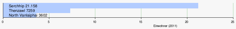
In the district there is only one urban settlement with the district capital Serchhip. Statistically, however, the three settlements Serchhip, Thenzawl and North Vanlaiphai count as towns.
District population by gender
With the exception of 1991, the proportion of both genders, which is quite atypical for India, is almost 50%.
| Distribution of the population by gender in Serchhip district | ||||||||||||||
| 1971 census | 1981 census | 1991 census | 2001 census | 2011 census | ||||||||||
| number | proportion of | number | proportion of | number | proportion of | number | proportion of | number | proportion of | |||||
| TOTAL | 34,381 | 100% | 37,803 | 100% | 46.222 | 100% | 54,460 | 100% | 64,937 | 100% | ||||
| Men | 17,540 | 51.02% | 18,868 | 49.91% | 23,702 | 51.28% | 27,691 | 50.85% | 32,851 | 50.59% | ||||
| Women | 16,841 | 48.98% | 18,935 | 50.09% | 22,520 | 48.72% | 26,769 | 49.15% | 32,086 | 49.41% | ||||
District population by language
Almost the entire population of Serchhip District speaks a Tibetan Burman language . The main language Lushai (also called Mizo) accounts for over 97 percent. Less than two percent of the population - mostly people who have immigrated from other regions - speak other languages. Most commonly spoken of these languages are Hindi, Bengali and Nepali.
| year | Lushai | Hindi | Meitei | Bengali | Nepali | Assamese | Total | |||||||
|---|---|---|---|---|---|---|---|---|---|---|---|---|---|---|
| number | % | number | % | number | % | number | % | number | % | number | % | number | % | |
| 2011 | 63,437 | 97.69 | 549 | 0.85 | 151 | 0.23 | 149 | 0.23 | 123 | 0.19 | 63 | 0.10 | 64,937 | 100.00% |
| Source: 2011 census result | ||||||||||||||
Population of the district by confession
The residents profess Christianity almost entirely. The most important communities within Christianity are the Presbyterians (Reformed), Baptists, and Catholics. The Muslims and Hindus form smaller religious minorities. The following table shows the exact religious composition of the population:
| year | Buddhists | Christians | Hindus | Jainas | Muslims | Sikhs | Other | not specified | Total | |||||||||
|---|---|---|---|---|---|---|---|---|---|---|---|---|---|---|---|---|---|---|
| number | % | number | % | number | % | number | % | number | % | number | % | number | % | number | % | number | % | |
| 2011 | 60 | 0.09 | 63,444 | 97.70 | 991 | 1.53 | 9 | 0.01 | 335 | 0.52 | 6th | 0.01 | 35 | 0.05 | 57 | 0.09 | 64,937 | 100.00% |
| Source: 2011 census result | ||||||||||||||||||
education
The goal of full literacy has almost been achieved. More than 98% of men and almost as many women can read and write. Literacy is well above the Indian average.
| Literacy in the Serchhip district | ||||||
| unit | 2011 census | |||||
| number | proportion of | |||||
| TOTAL | 54,476 | 97.91% | ||||
| Men | 27,598 | 98.28% | ||||
| Women | 26,878 | 97.53% | ||||
| TOTAL CITY | 27,382 | 98.23% | ||||
| City men | 13,851 | 98.30% | ||||
| City women | 13,531 | 98.17% | ||||
| TOTAL COUNTRY | 27.094 | 97.59% | ||||
| Country men | 13,747 | 98.27% | ||||
| Country women | 13,347 | 96.89% | ||||
| Source: 2011 census result | ||||||
administration
The district has a complicated administrative structure. Of the three sub-divisions (RD Blocks) at the last census in 2011, only Serchhip is entirely within the district. The other two are partly in the Aizawl district (Thingsulthliah), partly in the Champhai district (East Lungdar). Within the boundaries of the district it looks like this:
| Population in the sub-divisions | ||||||||||
| East Lungdar | Serchhip | Thingsulthliah | ||||||||
| number | proportion of | number | proportion of | number | proportion of | |||||
| TOTAL | 14,897 | 100% | 44,242 | 100% | 5798 | 100% | ||||
| Men | 7547 | 50.66% | 22,383 | 50.59% | 2921 | 50.38% | ||||
| Women | 7350 | 49.34% | 21,859 | 49.41% | 2877 | 49.62% | ||||
| city | 3602 | 24.18% | 28,417 | 64.23% | 0 | 0% | ||||
| country | 11,295 | 75.82% | 15,825 | 35.77% | 5798 | 100% | ||||
Individual evidence
- ↑ Serchhip District: Census 2011 data
- ↑ A - 2 DECADAL VARIATION IN POPULATION SINCE 1901
- ^ Result of the 2011 census on city population
- ↑ District Census Handbook Serchhip
Web links

Coordinates: 22 ° 17 ′ 24 ″ N , 92 ° 35 ′ 24 ″ E