Lepsi (river)
|
Lepsi Лепсі |
||
|
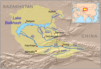
Course of the Lepsi in the catchment area of Lake Balkhash |
||
| Data | ||
| location | Alaköl , Aqsu , Sarqan in the Almaty region ( Kazakhstan ) | |
| River system | Lepsi | |
| source |
Djungarian Alatau 45 ° 12 ′ 13 ″ N , 80 ° 42 ′ 39 ″ E |
|
| muzzle |
Lake Balkhash coordinates: 46 ° 22 '7 " N , 78 ° 20' 22" E 46 ° 22 '7 " N , 78 ° 20' 22" E |
|
| Mouth height |
342 m
|
|
| length | 417 km | |
| Catchment area | 8100 km² | |
| Outflow at the Lepsi gauge |
MQ |
18.7 m³ / s |
| Outflow location: 12 km above the mouth |
MQ |
21.6 m³ / s |
| Left tributaries | Baskan | |
| Communities | Lepsi | |
The Lepsi ( Kazakh Лепсі ; Russian Лепсы Lepsy ) is a tributary of Lake Balkhash in the Almaty region in southeastern Kazakhstan .
The Lepsi rises on the glaciated northern flank of the Djungarian Alatau . He leaves the mountainous region near Lepsi (formerly Lepsinsk ). It then flows in a north-westerly and later in a westerly direction through the desert landscape of the Seven Streams and flows into the eastern part of Lake Balkhash after 417 km. The Lepsi drains an area of 8100 km². There are usually two flood events per year - one in spring and one in summer. The mean discharge 12 km above the mouth is 21.6 m³ / s. The river is ice-covered between November and March. Some of the water is diverted for irrigation purposes . The Baskan meets the lower Lepsi on the left.

