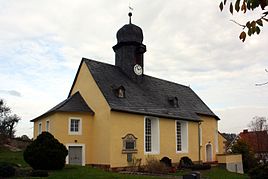
Letzendorf
|
Letzendorf
community Endschütz
Coordinates: 50 ° 47 ′ 39 ″ N , 12 ° 9 ′ 20 ″ E
|
|
|---|---|
| Height : | 270–291 m above sea level NN |
| Residents : | 120 |
| Incorporation : | January 1, 1957 |
| Postal code : | 07570 |
| Area code : | 036603 |
Letzendorf is a settlement in the municipality of Endschütz in the Greiz district in Thuringia .
geography
Letzendorf can be reached via the 512 district road. The village is northeast of Endschütz. The Pohlen water reservoir is located east of Letzendorf next to a forest area. To the south is the Letzendorf water reservoir .
history
Not until October 26, 1441 was it first mentioned in a document. The hamlet was and is characterized by agriculture.
church
Web links
Commons : Letzendorf - Collection of images, videos and audio files
Individual evidence
- ^ Wolfgang Kahl : First mention of Thuringian towns and villages. A manual. Rockstuhl Verlag, Bad Langensalza, 2010, ISBN 978-3-86777-202-0 , p. 163
