Lexington (Michigan)
| Lexington | ||
|---|---|---|
|
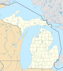
Location in Michigan
|
||
| Basic data | ||
| State : | United States | |
| State : | Michigan | |
| County : | Sanilac County | |
| Coordinates : | 43 ° 16 ′ N , 82 ° 32 ′ W | |
| Time zone : | Eastern ( UTC − 5 / −4 ) | |
| Residents : | 1,104 (as of: 2000) | |
| Population density : | 460 inhabitants per km 2 | |
| Area : | 2.4 km 2 (approx. 1 mi 2 ) of which 2.4 km 2 (approx. 1 mi 2 ) is land |
|
| Height : | 188 m | |
| Postal code : | 48450 | |
| Area code : | +1 810 | |
| FIPS : | 26-47280 | |
| GNIS ID : | 0630359 | |
| Website : | lexingtonmichigan.com | |
Lexington is a village in Sanilac County in the US state of Michigan , with 1,104 inhabitants (Census 2000 ). The village has an area of 2.4 km² and is located within Lexington Townships . The village's ZIP code is 48450. Lexington is located on Lake Huron , about 115 km north of Detroit .
The residents are German (24.7%), Irish (17.3%), British (13.5%), Polish (12.3%), French (9.7%) and French-Canadian (5.7%) Ancestry.
Web links
Commons : Lexington, Michigan - Collection of pictures, videos, and audio files
