Lincolnshire Loop Line
| Peterborough – Lincoln | |||||||||||||||||||||||||||||||||||||||||||||||||||||||||||||||||||||||||||||||||||||||||||||||||||||||||||||||||||||||||||||||||||||||||||||||||||||||||||||||||||||||||
|---|---|---|---|---|---|---|---|---|---|---|---|---|---|---|---|---|---|---|---|---|---|---|---|---|---|---|---|---|---|---|---|---|---|---|---|---|---|---|---|---|---|---|---|---|---|---|---|---|---|---|---|---|---|---|---|---|---|---|---|---|---|---|---|---|---|---|---|---|---|---|---|---|---|---|---|---|---|---|---|---|---|---|---|---|---|---|---|---|---|---|---|---|---|---|---|---|---|---|---|---|---|---|---|---|---|---|---|---|---|---|---|---|---|---|---|---|---|---|---|---|---|---|---|---|---|---|---|---|---|---|---|---|---|---|---|---|---|---|---|---|---|---|---|---|---|---|---|---|---|---|---|---|---|---|---|---|---|---|---|---|---|---|---|---|---|---|---|---|---|
|
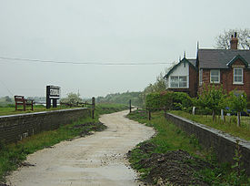
Disused Stixwould train station
| |||||||||||||||||||||||||||||||||||||||||||||||||||||||||||||||||||||||||||||||||||||||||||||||||||||||||||||||||||||||||||||||||||||||||||||||||||||||||||||||||||||||||
| Route length: | approx. 95 km | ||||||||||||||||||||||||||||||||||||||||||||||||||||||||||||||||||||||||||||||||||||||||||||||||||||||||||||||||||||||||||||||||||||||||||||||||||||||||||||||||||||||||
| Gauge : | 1435 mm ( standard gauge ) | ||||||||||||||||||||||||||||||||||||||||||||||||||||||||||||||||||||||||||||||||||||||||||||||||||||||||||||||||||||||||||||||||||||||||||||||||||||||||||||||||||||||||
| Dual track : | Peterborough – Spalding, the rest shut down and dismantled |
||||||||||||||||||||||||||||||||||||||||||||||||||||||||||||||||||||||||||||||||||||||||||||||||||||||||||||||||||||||||||||||||||||||||||||||||||||||||||||||||||||||||
|
|||||||||||||||||||||||||||||||||||||||||||||||||||||||||||||||||||||||||||||||||||||||||||||||||||||||||||||||||||||||||||||||||||||||||||||||||||||||||||||||||||||||||
The Lincolnshire Loop Line was an approximately 95 km long double track railway line built and operated by the Great Northern Railway to connect Peterborough to Lincoln via Spalding and Boston . The route from Lincoln to Boston was also called the Witham Loop Line because it followed the course of the navigable river Witham .
history
The Lincolnshire Loop Line was approved by Parliament on June 26, 1846 as part of the London and York Railway Bill . The newly renamed Great Northern Railway acquired the navigation rights of the River Witham as early as 1846 and began construction of a new railway line mainly along the river in 1847. The railway line opened in 1848 and was the main route from London to northern England and Scotland for a short time until the line from Peterborough to Doncaster opened. The line was shut down in sections, with the section from Woodhall Junction to Boston being the first to no longer be used for passenger traffic from June 17, 1963.
Route
The route ran through Washingborough , Five Mile House , Bardney , Southrey , Stixwould , Tattershall , Dogdyke and Langrick . The route from Boston to Spalding ran via Kirton , the common train station of Algarkirk and Sutterton and Surfleet . Your route is now used by the A16 road. The last section to Peterborough was via Littleworth , St James Deeping and Peakirk stations . This section of the route continues to operate, but most stations no longer stop. There are only four passenger train stations left in Lincoln, Boston, Spalding and Peterborough North.
Water Rail Way
The route from Boston to Lincoln is now a part of the national cycle path 1 ( National Cycle Route 1 ) and Water Rail Way , called a play on words from the English words for Water Rail ( Water Rail ) and Railway ( Railway ).
Web links
Individual evidence
- ^ The National Archives: Great Northern Railway Company: Records
- ↑ Disused Stations . Subterranea Britannica.
- ↑ a b c A.J. Ludlam: Lincolnshire Loop Line (GNR) and the River Witham (= Locomotion Papers). The Oakwood Press, July 1995, ISBN 978-0-85361-464-7 .
- ^ Water Rail way . Sustrans. Retrieved March 12, 2013.
- ^ Photographs of Water Rail Way . Geographer. Retrieved March 12, 2013.
Coordinates: 53 ° 8 ′ 32.6 " N , 0 ° 14 ′ 30.8" W.
