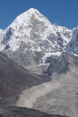
Drangnag Ri
| Drangnag Ri | ||
|---|---|---|
|
Dragnag Ri from the south |
||
| height | 6801 m | |
| location | Districts Dolakha , Solukhumbu ( Nepal ) | |
| Mountains | Rolwaling Himal ( Himalaya ) | |
| Dominance | 9.5 km → Tengi Ragi Tau | |
| Notch height | 951 m ↓ ( 5850 m ) | |
| Coordinates | 27 ° 56 '22 " N , 86 ° 31' 27" E | |
|
|
||
| First ascent | April 30, 1995 by Bjørn Myrer Lund , Ralph Høibakk , Chris Bonington , Pema Dorjee and Lhakpa Gyalu | |
The Drangnag Ri or Dragnag Ri is a mountain in the Himalayas in the Rolwaling Himal mountain range .
The 6801 m high Drangnag Ri lies on the border of the Nepalese administrative zones Janakpur and Sagarmatha not far from the border with Tibet . The Mount Everest located 40 km towards the east-northeast. On the southeast edge of the Drangnag Ri flowing Drolambaogletscher , on the northeast flank of the Ding Jung glacier and on the west flank of the Ripimo-Shar Glacier .
The Drangnag Ri was first climbed by a Norwegian expedition in 1995. Due to worsening weather conditions, only five instead of ten expedition participants climbed the summit. On April 30, 1995 Bjørn Myrer Lund , Ralph Høibakk , Chris Bonington , Pema Dorjee and Lhakpa Gyalu reached the summit via the east ridge.
Web links
- Drangnag Ri on Peakbagger.com (English)

