
Lindenthal Canal

The Lindenthaler channel (also Lindenthaler channels ) with its mutual verges is a radial connection between the inner and outer Cologne green belt . It runs in Cologne-Lindenthal and is accompanied from the Italian Cultural Institute on Universitätsstraße or Danteweg by Clarenbachstraße and the Danteweg, which continues as a footpath, and in the second part after Brucknerstraße on both sides by Rautenstrauchstraße. The design of the canal was implemented in 1925 by horticultural director Fritz Encke on the basis of Fritz Schumacher's general development plan from 1920 to 1923.
General
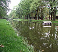
The Clarenbachstrasse canal section lies in the extended east-west axis of the Aachener Weiher and leads to the Church of Christ Resurrection , which was designed by the architect Gottfried Böhm . This part of the canal system, also known as the Clarenbach Canal, was planted with horse chestnuts at the time it was built, which today form a sweeping avenue. The connection to the staggered canal system on Rautenstrauchstrasse forms the Brucknerstrasse with the Liebfrauenschule in Cologne , which continues as a footpath to Karl-Schwering-Platz with the Apostelgymnasium and various green spaces such as a rose garden, a sand playground and a geometric part of the square leading to Dürener Strasse.


Canal on Clarenbachstrasse

View towards Aachener Weiher

Centaur and Naiad
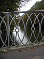
Bridge on the Clarenbachstrasse section
Rautenstrauchstrasse canal section


The Rautenstrauchstrasse canal section, also known as the Rautenstrauch Canal , begins with a round water basin, which is flanked by the two sculptures "Centaur and Naiade", which were created in 1930 by Eduard Schmitz based on designs by Georg Grasegger . From here the canal, which is divided into three segments, leads to the Lindenthal Belt, from which you can enter the city forest . This section is planted with maple trees and was provided with new road surfaces in 2007.
The canal's fauna consists of fish, Canada geese, coots, and mallards. The swans that used to be there were brought to the Decksteiner Weiher in 2018 .
history

The Lindenthal Canal was created out of the desire to create a sizable green street from the densely built-up city there.
Commissioner Schumacher explained his plans: “Finally, to the west, the impression of the water basin is extended by a long canal system lined with wide strips of greenery. On the other side (this canal is closed) by a church. The entire, almost 600 m long facility has roughly the same width dimensions (100 m) as the Königsallee in Düsseldorf. At the end point where the church is located, the green strip widens in a cross shape; the southern arm gives the connection with another strip of water embedded in green, which leads through the Rautenstrauchstrasse into the city forest, thus integrating this large park area into the new green network. The northern arm is in connection with the future park, which the current Melatenfriedhof will one day be. "
The restoration of the horticultural-historically significant work was carried out on the initiative and with the support of the Cologne Green Foundation .
literature
- Ute Fendel: Culture Paths Cologne-Lindenthal . City of Cologne, Cologne 2000.
- Konrad Adenauer / Volker Gröbe: Streets and squares in Lindenthal . JP Bachem Verlag, Cologne 1992, ISBN 3-7616-1018-1 .
Individual evidence
- ↑ Clarenbach Canal (Cologne city drainage)
- ↑ Rautenstrauchkanal (city drainage Cologne)
- ^ René Zey: Parks in Cologne: A guide through the green spaces . Greven, Cologne 1993, ISBN 3-7743-0273-1 , p. 127 ff .
- ↑ Lindenthal Canal. (Short description) In: Kölner Grün Foundation. Retrieved June 17, 2019 .
Web links
- Website of the Cologne Green Foundation
- Project , Regionale 2010 (PDF)
Coordinates: 50 ° 56 ′ 1 ″ N , 6 ° 55 ′ 0 ″ E