
Lindenthal (Cologne)
|
district 303 of Cologne |
|
|---|---|
 |
|
| Coordinates | 50 ° 55 '34 " N , 6 ° 54' 36" E |
| surface | 7.73 km² |
| Residents | 30,602 (Dec. 31, 2018) |
| Population density | 3959 inhabitants / km² |
| Incorporation | 1888 |
| Post Code | 50931, 50933, 50935, 50937 |
| prefix | 0221 |
| Borough | Lindenthal (3) |
| Transport links | |
| Federal road |
|
| Light rail lines | 1 7th 13 |
| Bus routes | 136 142 146 |
| Source: 2017 residents . (PDF) Cologne district information | |

Lindenthal is a district on the left bank of the Rhine in Cologne . It is located in the Lindenthal district of the same name in the west of the city.
location
The Lindenthal district is located southwest of Cologne city center, between the inner and outer green belts . Lindenthal borders in the east on the Neustadt-Süd district , in the south on Sülz and at the transition of the "Grenzstraße" Gleueler Straße over the federal highway 4 to the city of Hürth , in the west on Junkersdorf and in the north on Müngersdorf , Braunsfeld and Ehrenfeld .
History of the district
The district has belonged to the city of Cologne since 1888. A large part of the area belonged to the mayor's office Efferen . Its history is shaped by the large number of farms, villages and hamlets (Kriel, Lind, Deckstein, Hohenlind, Melaten) that were once on its territory.
The foundation
The residents of the mayor's office in Efferen in today's Cologne city area were distributed as follows in 1831:
| parish | places | Characteristic | Cath. | Evang. | Jew. | Total | Fire pits |
|---|---|---|---|---|---|---|---|
| Kriel | Capstone | Courtyard with watermill | 27 | 27 | 2 | ||
| Kitsch castle | Country house | 11 | 11 | 2 | |||
| Kriel | Courtyard with rectory and sexton's shop | 19th | 19th | 3 | |||
| Lind | Hamlet with a watermill | 125 | 125 | 17th | |||
| Lindenburg | Country house and courtyard | 10 | 10 | 2 | |||
| St. Mauritius in Cologne | Neuenhof | Courtyard | 13 | 13 | 1 | ||
| total | 205 | 205 | 27 |
The citizens of Cologne Thelen and Fühling drafted a plan in 1843 to found a residential colony because they wanted to go down in the history of Cologne as the founding fathers of a district . On the country road to Düren , in the area of today's Dürener, Falkenburg, Herder and Theresienstraße, they acquired around ten hectares of land, divided it into plots and laid out paths. They sold the individual properties to employees and civil servants at affordable prices. The chosen place name refers to the linden road to Düren and the valley location of the new foundation between Linder Höhe and Hohenlind.
Lindenthal was officially founded in 1846 with the construction of the first house on Dürener Straße. In the following time, the newly created suburb quickly became one of the most sought-after residential areas in Cologne. Other suburbs developed everywhere beyond the ring walls in the newly available surrounding area, but unlike these, in addition to the towns on the right bank of the Rhine, Thielenbruch, Refrath and Frankenforst on the left bank of the Rhine, only Marienburg and Lindenthal remained industrial-free and pure residential areas with lots of green. The areas around the Weyertal / Bachemer Strasse area as well as around the city forest and city forest belt have developed into pure residential areas since the 1880s.
Just a few years after it was founded, 2,662 people were registered in Lindenthal, many times the number of residents in neighboring Kriel . The suburb continued to grow, in 1864 the mayor's office of the Mayor's office in Efferen was relocated to Falkenburg, which is on the corner of Krieler Strasse and Falkenburgstrasse. Nevertheless, until it was incorporated into Cologne in 1888, the up-and-coming suburb belonged to the rural community of Kriel as well as Lind, Lindenburg, Linderhöhe, Deckstein, Neuenhof and Kitschburg.

Cenotaph at the Stadtwaldweiher

Monument, Morsdorfer Strasse
Marienbildchen around 1870, Falkenburgstrasse

Postal settlement, Dürener Strasse


Citizen Mobility
Individual traffic and transport options at that time were extremely poor. Although the Lindenthal population largely consisted of employees and civil servants working in the city center, the city had no interest in setting up public transport routes to the non-urban outskirts until it was incorporated in 1888. It was not until the private horse-drawn tram lines established in 1877 (the licenses for this were granted by the Prussian state, not by the city) that Lindenthal again increased its population. At the turn of the century, 63 km of routes could be traveled in Cologne. The horse-drawn tram meanwhile had 1,000 employees, 834 horses and almost 350 wagons. Around 30 million passengers were carried every year.

In the period between 1890 and 1895, the steam train also came into play due to the need to remove the Frechen brown coal . Lindenthal also benefited from this, and in 1904 the Cologne-Frechen-Benzelrath railway became the property of Cologne. Line F, affectionately known as "Finchen" by the people of Cologne, will later become line 20, then line 2 and today it is line 7.
Incorporation April 1888
In the course of the incorporation negotiations between the mayor's office Efferen and the city of Cologne in 1888, the places of the rural community of Kriel and parts of the mayor's office of Müngersdorf (Melaten, Weyertal and Linder Höhe) were combined to form the new suburb of Cologne-Lindenthal.
In order to ensure uniform administration in the new urban areas, Lindenthal followed the example of the other districts and was divided into districts 60, 61 and 62.
Planting the city forest

Many of the estates and farms in the vicinity of Kriel and Lindenthal, like the Kitschburg, were owned by clerical corporations and were secularized during the French period . In 1894 the city of Cologne acquired the Kitschburg with its English landscape park and adjacent lands in the area between Dürener Strasse and Aachener Strasse ; a total of 412 acres .
On July 4, 1895, the City Council of Cologne decided, on the basis of the draft submitted by Horticultural Director Adolf Kowallek, to move the huge area (at that time 150 hectares) into a park area characterized by historicism , the Cologne city forest , with sports and playgrounds Trees, ponds and canals as well as gastronomic facilities such as the "Cöln Lindenthal Waldschenke" and the Stadtwaldrestaurant in the Kitschburg building.
At the turn of the century, the expensive project (2.5 million gold marks ) was realized, but redesigns and extensions were made until 1910. The current area of the city forest, in which the Lindenthal Zoo is located, is 205.3 hectares.
At that time, the former open spaces between the localities had become denser, Kriel, Lindenthal, Linderhöhe and Weyertal had more or less grown together to form a closed settlement area. Only Lind and Hohenlind were separated from the new settlement area by parks and the agricultural complex of the Kitschburg. The settlement of large parts of Deckstein was prevented until the 20th century by the facilities in the fortress pale of the Cologne fortress ring.

Canal in the city forest

Direction Dürener Straße
Middle of Kitschburger Strasse

At the Lindenthal Canal


Allotment gardens and green belts
In Deckstein, in connection with the construction of the section of the outer green belt around the Decksteiner Weiher at the level of the Decksteiner Mühle on Aquarienweg, an allotment garden was created based on a design by the garden architect and head of the planning department of the Cologne gardening authority, Theodor Nussbaum . In terms of its urban integration, it corresponded completely to Fritz Schumacher's idea . From 1920 to 1923, as town planner under Lord Mayor Konrad Adenauer, he also accompanied the demolition of the fortress rings of Cologne , the planning of which envisaged leased gardens as a link between residential development and landscaped greenery. The complex, which has been preserved until today, comprises 578 individual gardens and is a listed building.
Other gardens, mostly in the Lindenthal Garden Association from 1920 e. V., on Freiligrathstrasse (6,678 m²), Decksteiner Strasse (6,366 m²), Schlegelstrasse (2,829 m²), Werthmannstrasse (1,140 m²) and Dürener Strasse (3,000 m²) were closed by 1957, at the latest in 1965, and released as building land.

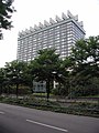
former Holiday-Inn Hotel (2008)

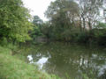
Pond in the city forest
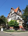
House Kitschburger Strasse 1, built in 1903

House Dürener Str. 285, remainder of the Kitschburg estate


Architecture and development
Kitschburg estate
In 1971 the newly built " Esso Motor Hotel " was opened, which was then run by the Holiday Inn chain and is now part of the Leonardo Hotels chain . Up until the construction of this modern hotel complex at the end of the sixties, the lordly, classicist country house of the Kitschburg estate stood in its place . It was built in 1814/15 and later served as the Stadtwald restaurant. In 1969 the building was blown up. The Kitschburg complex also included a small farmstead (today Dürener Straße 285), whose Baroque house, built in 1759, is the only remaining relic of the former court estate.
Urban development 1917–1933
The publicly subsidized housing construction in Cologne was an association of the city, companies, cooperatives and individuals created in 1913 under the name GAG . The city held around half of the start-up capital in this company, and the mayor of the city, Konrad Adenauer , was the chairman of the supervisory board . However, this new company only really started to improve at the end of the inflation period around 1924.


Settlement construction experienced a real boom in Cologne in the 1920s: Whole districts were built by housing cooperatives, mostly according to the urban planning ideals of the time and often according to the principles of the garden city .
Adenauer's conception as GAG chairman ensured that Cologne operated one of the most efficient housing construction policies of all cities in the Weimar Republic. Relative to the number of residents, a particularly large number of high-quality apartments were built, which also led to social housing construction in Cologne being assigned the characteristics of "light, air and trees". Adenauer managed to mobilize a particularly large number of forces for this.
The buildings of Wilhelm Riphahn in Birresborner and Bitburger Strasse , which are still largely preserved, are characteristic of the architectural style of the thirties . With the planned expansion of the open spaces still available, typical rows of houses were built according to the taste of the building companies, for example in Kerpener, Mommsen- and Krieler Straße. Multi-storey three- and four-window houses, such as those in downtown Cologne or quite typical for Ehrenfeld, were also built in Bachemer, Theresienstrasse or Wittgensteinstrasse. For the most part, however, people stayed true to their preference for living in the countryside. Beautiful front gardens, splendid villas embedded in parks, ponds and artificially created canals - all of these were liked and could be afforded.
In 1925, the Lindenthal Canal , a connection from the inner green belt at the Aachener Weiher to the urban forest area in the outer Cologne green belt, was created along the Rautenstrauchstrasse and Clarenbachstrasse with water surfaces and playgrounds . In addition, Lindenthal had and still has an abundance of green spaces through the parks of the monasteries and the sometimes quite large gardens of the hospitals.

The new university was also an example of the New Objectivity architectural style ; it was built in the style of the Werkbund . The foundation stone was laid in 1929, and in November 1934 the university was able to move into a functionally simple new building in the inner green belt near the medical faculty, built by the architect and city planning director in Cologne Adolf Abel . It remained a municipal university until 1953 and then became the sponsorship of the state of North Rhine-Westphalia. Today it is one of the largest universities in Germany with more than 43,000 students.
School system
After the first own school in Lindenthal, the one-room dwarf school for 22 children on Krieler Dömchen , they moved into a new school building built in 1865 on the corner of Gleuelerstrasse and Schlegelstrasse. Even this school, initially designed with two parallel classes for boys and girls, was no longer able to cope with a rapidly growing number of pupils after just a few years, despite an extension. The then owner of the Kitschburg estate donated building land in 1875/76 for another school in the new Lindenthal in Hillerstraße. Due to the increasing number of children, this also had to be expanded after a short time, especially since children from the nearby Braunsfeld could also be registered in this school.

In red brick, the taste of the turn of the century, the next larger school built by city architect Busse was inaugurated in Lindenburger Allee. In the first year, 750 children attended this modern elementary school. From the spring of 1915 the school became a military hospital for the duration of the First World War. The later introduction of denominational schools led to the establishment of the Protestant school on the corner of Bachemerstrasse and Schallstrasse in 1960. The oldest secondary school was the Stein-Hardenberg- Gymnasium on Gyrhofstrasse. The new building, which was completely destroyed in the Second World War, was built for around 750,000 marks and inaugurated by Mayor Max Wallraf in 1913 . In the neighboring Weyertal there was a high school for girls, the municipal Lyceum III.
In 1956 the Johann Joseph Gronewald School for Deaf Children was established in Gronewaldstrasse .
Monasteries, churches, hospitals

The Krieler Dömchen with its property and the Leprosenhaus on the site of today's Melatenfriedhof go back to the 13th and 14th centuries and are the oldest documented forerunners of the later variety of churches and monasteries as well as welfare institutions and hospitals in Lindenthal. The Sankt-Anna-Kapelle in Herderstraße is mentioned for the first time in 1696. The Anna-Haus, originally an establishment of the Cellitinnen from Kupfergasse, still has a neo-Gothic chapel as an extension on the garden side.
The Church of Christ Resurrection by Gottfried Böhm from 1968 is a highly regarded building from more recent times.
St. Anna House

Originally founded as a novitiate , the Cellitinnen ran outpatient care services for elderly women. After the outbreak of the First World War on August 1, 1914, Cologne became an important base for the care of injured soldiers because of the direct rail connections to the western theater of war. Since the Second World War , after making some structural adjustments, it has been serving as a general hospital for decades. In 1980, regular hospital operations in the Sankt-Anna-Haus in Herderstrasse were discontinued.
St. Hildegardis Hospital
A similar chapel, which belonged to the former monastery of the Alexians , can be found in the current St. Hildegardis Hospital on Bachemer Strasse, which emerged from the convent of the Alexian Brothers.
Evangelical hospital and orphanage

In autumn 1902 the Evangelical Hospital and the Evangelical Orphanage were inaugurated at the same time in Weyertal . The new buildings were made possible by significant donations from well-known Protestant families from Cologne. This further hospital in Lindenthal, designed by the Leipzig architect Alfred Ludwig , was a brick building with pavilion elements and a huge garden on an area of 32,000 m². In 1967 the hospital was rebuilt in its current form, now supplemented by a dormitory for students, employees and trainees.
Lindenburg
Johann Heinrich Richartz not only donated the money (232,000 thalers) for the first museum building in Cologne in 1861, he also left the city 100,000 thalers for the construction of a "sanatorium and nursing home", for which he made it a condition that only Cologne residents Should serve citizens. This institution became the "Lindenburg" - the later University Hospital Cologne .
In earlier times, Lindenburg was the name given to an estate of the order of the Antonite monks located between Bachemer Strasse and Gleueler Strasse . The Lindenburg- Coeln municipal hospital was founded on this approximately 120,000 m² site at the beginning of the 20th century . In a construction period of almost three years, 35 buildings were erected under the direction of building inspector Johannes Baptist Kleefisch . On the Lindenburg area there was a chapel and convent of the Cellitinnen from 1905 to 1910 even before the new buildings were built. Today, the hospital has its own, by architect Gottfried Böhm designed church in Josef-Stelzmann Street which John the Baptist is dedicated.
The name of the KVB stop on tram line 9 on Zülpicher Strasse and the corner of Josef-Stelzmann-Strasse is still reminiscent of the name “Lindenburg” .
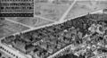
Lindenburg Coeln, built between 1905 and 1909

Church of John the Baptist

Lindenhof on Josef-Stelzmann-Straße
Ward block of the university hospital


Hohenlind
The Sankt Elisabeth Hospital, also called "Hohenlind" after its location on the site of the former manor, went into operation in October 1932 as a training hospital sponsored by Caritas . The estate, which gave the district its name, also comprised the Mönchhof, the Platzhof and a water mill in 1867 with an area of 684 acres.
The new hospital on what is now Werthmann - / Prälat-van-Acken- Strasse, as it was now in the old, 16-acre park of the former estate, made viewers of the time resort to superlatives: "the largest hospital in West Germany", "a Work that has no equal in Germany ”,“ A city for itself ”or“ a hospital as it should be ”were the comments. The ecclesiastical hospital is now also the academic teaching hospital of the University of Cologne. Part of the hospital is the remarkable St. Elisabeth Church by Dominikus Böhm with numerous pieces of equipment by Ewald Mataré .
Geusenfriedhof
Ursula von Gohr zu Kaldenbroek donated a piece of land for the cemetery in front of the Weyertore as early as 1576 . The 7,200 square meter property was until 1829 when the Geusen cemetery in Cologne was the only resting place for Protestant dead.
Red Church
.JPG)
On July 9, 1900, at 7.30 p.m. in the presence of the church bodies, the groundbreaking ceremony for the Paul Gerhardt Church was done and the foundation stone was ceremoniously laid on August 5 at 11 a.m. The shell was completed on December 31st and the church was consecrated on November 3rd, 1901. The total cost was 112,000 Reichsmarks.
The church at the intersection of Gleueler Straße and Lindenthalgürtel was the first Protestant church in Lindenthal, a neo-Gothic brick building. Since it did not have a name at the beginning, the vernacular gave it the name "Red Church", which is still used today. It was almost completely destroyed in 1944. It was given the name "Paul Gerhardt Church" when it was rebuilt in 1951.
The second World War
Lindenthal was 85% destroyed by the bombing of World War II. A memorial plaque on Dürener Strasse 89 commemorates Saint Edith Stein , who was murdered in the Auschwitz concentration camp and was a member of the Cologne Convention of Discalced Carmelites . The Edith Stein Archive is located in the Carmel of St. Mary of Peace , which was rebuilt after the last world war, in the southern part of Cologne.
post war period

The particularly severe destruction of the last world war in Lindenthal also affected the retail trade. Here and there, preferably at intersections, there was a new beginning and a new beginning. A baker's and butcher's shop joined the small grocery store on the corner, and a few houses next to it a tailor tried a rescued sewing machine. It was not until the 1970s, for example, that Dürener Strasse from Hans-Sachs-Strasse to Lindenthalgürtel once again offered a closed picture. A cinema that was opened at that time, the “Corso” on Dürener Strasse, has, however, similar to the one in other suburbs (for example the “Roland Cinema” in Sülz), has not been able to save itself into the present day.
At the end of the 1960s, against considerable protests, the Stadtwald restaurant at the Stadtwaldweiher was torn down and replaced by the Esso Hotel (today: Leonardo Royal Hotel Cologne ).
present
Today you can shop in the immediate vicinity of the city forest and the Cologne green belt on Dürener Strasse and the Lindenthal belt , here you can also find various banks and a large number of hotels. Dürener Straße in particular offers a number of shops for high demands and around two dozen pubs, restaurants, cafes, bistros and pubs. The phase of reconstruction and the economic miracle left almost no traces.
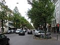
Dürener Strasse
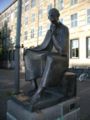
Albertus Magnus in front of the University of Cologne

WISO building of the University of Cologne

Restoration example: Art Nouveau in Scheffelstrasse


Population structure
Structure of the population of Cologne-Lindenthal:
- Proportion of under 18-year-olds: 11.6% (2014)
- Proportion of over 64-year-olds: 18.2% (2014)
- Proportion of foreigners: 9.8% (2015)
- Unemployment rate: 3.3% (2014)
Public institutions and museums
- District town hall Lindenthal
- Museum of East Asian Art (Cologne)
- Japanese Cultural Institute
- Consulate General Italy and Italian Cultural Institute Cologne
Churches and social institutions


- Evangelical parish Cologne-Lindenthal
- Christ's Resurrection , Bruckner Strasse
- Krieler Dömchen
- St. Albertus Magnus in Kriel
- St. Laurentius , An Sankt Laurentius (profaned since 2019)
- John the Baptist (St. Elisabeth Hospital)
- Paul Gerhardt Church, Lindenthal Belt
- Sankt Stephan , Bachemer Strasse
- Sankt Thomas More , Decksteiner Strasse
- Chapel in the Sankt-Anna-Haus, Herderstrasse and Hildegardis Hospital, Bachemer Strasse,
- Free Evangelical Congregation Cologne-Lindenthal, Clarenbachstrasse
- Katharina-von-Bora-Haus, senior citizens' home of Diakonie Michaelshoven , urban forest belt
Colleges and schools
- University of Cologne
- Rhenish school for the hard of hearing
- Liebfrauenschule Cologne
- Lindenburger Allee elementary school
- Primary School Bachemer Straße
- Furniture trade college (Frangenheimstrasse)
Apostle High School
The Catholic grammar school was first put into operation in 1860 opposite the St. Aposteln Basilica near Neumarkt in Cologne city center and there in 1939 due to urban development measures - the construction of today's Hahnenstrasse - was dissolved and demolished. After the Second World War, provisional lessons began in the building of an old hat factory in Lotharstrasse in Cologne-Sülz. In 1959 the foundation stone of today's building in Lindenthal was laid, and in 1961 the school moved in and started operations.
traffic
Aachener Strasse and Zülpicher Strasse, which flank the district, lead directly into the city center. As arterial roads, the Dürener and Aachener Strasse are connected to the federal motorway 4 .
Lindenthal has connections to local public transport with the tram lines 1, 7 and 13 as well as the bus lines 136, 142 and 146.
Daughters and sons of the Veedel
- Peter Kintgen (1884–1957), teacher and dialect poet
- Kurt Welter (1916–1949), fighter pilot
- Klaus Hartmann (1929–2019), board member and president of 1. FC Köln
- Robin Dutt (* 1965), football coach
literature
- Konrad Adenauer, Volker Gröbe: Lindenthal. The development of a Cologne suburb. Bachem, Cologne 2004, ISBN 3-7616-1603-1 .
- Konrad Adenauer, Volker Gröbe: Streets and squares in Lindenthal. Cologne 1992.
- Ute Fendel: Culture Paths Cologne Lindenthal. Published by the City of Cologne / District Representation Lindenthal. Cologne 2000.
Web links
References and literature
- ↑ Clemens Klug: Hürth as it was, as it was. Homeland association of the community of Hürth, Hürth 1961
- ↑ a b Inhabitants by selected age groups - data source: City of Cologne - offenedaten-koeln.de
- ↑ Inhabitants by type of migration background - data source: City of Cologne - offenedaten-koeln.de
- ↑ Employed and unemployed part of the city - data source: City of Cologne - offenedaten-koeln.de
Braunsfeld | Junkersdorf | Klettenberg | Lindenthal | Lövenich | Müngersdorf | Sülz | Pastures | Widdersdorf