
List of architectural monuments in Northeim


In the list of architectural monuments in Northeim , listed buildings of the Lower Saxon community Northeim ( district Northeim ) are listed. This list is based on the monument topography published in 2002.
General
The columns contain the following information:
- Location: the address of the monument and the geographical coordinates . Map view to set coordinates . In the map view, monuments without coordinates are shown with a red marker and can be set on the map. Architectural monuments without a picture are marked with a blue marker, architectural monuments with a picture with a green marker.
- Official name: Name of the monument
- Description: the description of the monument. Under § 3 (2) NDSchG individual monuments and under § 3 (3) NDSchG groups of structures and their components are shown.
- ID: the number of the monument
- Image: a picture of the monument
The architectural monuments of the outskirts of the city of Northeim are in the list of architectural monuments in Northeim (outer districts) .
Architectural monuments in the old town center
The old town center is an area of historical interest. It contains individual monuments and groups of structures in the streets Am Münster, Breite Straße, Schaupenstiel, Entenplan, Markt, Hinter der Kapelle, Kirchplatz, Hagenstraße, Neustadt, Holzhäuser Straße and Mühlenstraße. The green area of the former ramparts with the water areas they contain, as evidence of the city fortifications and later deconsolidation, are of monumental value.
City fortifications
The construction of the city wall began in 1252 and was completed in 1305. Originally the city wall ring was 1750 m long and around 9 m high and covers an area of 21.8 hectares. The three gates Unteres Tor or Mühlentor in the north, Höckelheimer Tor in the west and the Upper Gate in the east are separated from the bulwark tower at the upper gate. In the first third of the 15th century a wall and ditch system was created. The outer moat was created in the form of dammed ponds. The rest of these ponds are still preserved in the south. Mighty gate bulwarks were also built for the outer wall. In addition to the three gate ramparts, four ramparts were also built. In the 17th century there should still have been 48 internal and 15 kennels. During the Thirty Years' War the city fortifications withstood the sieges for a long time. The outbreak of the plague and political pressure led to a surrender of Northeim and, as a result, to its defecation. The citizens were forced to remove the wall, especially in the north, and fill the inner ditch with it. In 1788 the western wall was converted into a cemetery complex. This old cemetery was closed in 1885 and converted into a green area. The old city gates were demolished in 1773/74. In 1874/76 a longer section of the city wall in the north was torn down for the construction of today's Friedrich-Ebert-Walls. About half of the original wall sections are still preserved and were renovated from 1981 to 1983. Of the wall towers, a half-shell tower in the northwest and a tower basement at the Zwinger have been preserved.
| location | designation | description |
ID |
image |
|---|---|---|---|---|
| Schaupenstiel 20 51 ° 42 ′ 22 ″ N, 10 ° 0 ′ 18 ″ E |
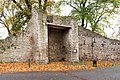
Upper gate | Only the southern bulwark tower with a diameter of 10 m and a wall thickness of 3 m from 1468 (building inscription) has survived from the Upper Gate. The northern flank tower of the Upper Gate had a diameter of 4.5 m and was demolished. Protected according to § 3 (2) NDSchG |
 More pictures |
|
| 51 ° 42 ′ 17 "N, 10 ° 0 ′ 13" E | Wall-trench plant |

|
||
| Kennel 51 ° 42 ′ 16 ″ N, 9 ° 59 ′ 51 ″ E |
Bulwark |

|
||
| Gardekürassierstrasse 51 ° 42 ′ 24 ″ N, 9 ° 59 ′ 41 ″ E |
Former old cemetery | formerly ramparts |

|
|
| Bleaching Wall 51 ° 42 ′ 26 ″ N, 10 ° 0 ′ 16 ″ E |
park | formerly ramparts |

|

City wall on Unteren Strasse with a fragment of a tower

City wall on Unteren Strasse

City wall on Unteren Strasse
City wall on Unteren Strasse with the rest of a half-shell tower

City wall at Mauerstraße 1

City wall east of Mauerstraße 7

City wall north of Häuserstraße 13

City wall on the street Obere Mauer

City wall on the street Obere Mauer

City wall on the Zwinger road

City wall on the Zwinger road


At the Münster / Breite Strasse / Schaupenstiel
The streets Am Münster, Breite Straße and Schaupenstiel are the backbone of the medieval street system and were once on an important long-distance trade route.
At the minster
| location | designation | description |
ID |
image |
|---|---|---|---|---|
| Am Münster 1 51 ° 42 ′ 18 ″ N, 9 ° 59 ′ 44 ″ E |
Residential and commercial building | Protected according to § 3 (3) NDSchG |
 More pictures |
|
| Am Münster 2 51 ° 42 ′ 18 ″ N, 9 ° 59 ′ 44 ″ E |
Residential and commercial building | Protected according to § 3 (3) NDSchG |
 More pictures |
|
| Am Münster 3 51 ° 42 ′ 18 ″ N, 9 ° 59 ′ 44 ″ E |
Residential and commercial building | Protected according to § 3 (3) NDSchG |
 More pictures |
|
| Am Münster 4 51 ° 42 ′ 18 ″ N, 9 ° 59 ′ 45 ″ E |
Residential and commercial building | Protected according to § 3 (3) NDSchG |
 More pictures |
|
| Am Münster 5 51 ° 42 ′ 18 ″ N, 9 ° 59 ′ 45 ″ E |
Residential and commercial building | Protected according to § 3 (3) NDSchG |
 More pictures |
|
| Am Münster 6 51 ° 42 ′ 18 ″ N, 9 ° 59 ′ 46 ″ E |
Residential and commercial building, so-called Reddersen house | Six-tier post-storey building, the ground floor and mezzanine are combined by high, originally continuous posts; Ground floor completely changed. Protected according to § 3 (2) NDSchG |
 More pictures |
|
| Am Münster 7 51 ° 42 ′ 18 ″ N, 9 ° 59 ′ 46 ″ E |
Residential and commercial building | The house was built in the early 16th century. The house has changed a lot over time. Protected according to § 3 (3) NDSchG |
 More pictures |
|
| Am Münster 8 51 ° 42 ′ 18 ″ N, 9 ° 59 ′ 46 ″ E |
Residential and commercial building | The house was built at the beginning of the 16th century as a six-tier post-storey building. The facade has been preserved, but the ground floor has been gutted. Protected according to § 3 (2) NDSchG |
 More pictures |
|
| Am Münster 9 51 ° 42 ′ 18 ″ N, 9 ° 59 ′ 47 ″ E |
Residential and commercial building | Protected according to § 3 (3) NDSchG |
 More pictures |
|
| Am Münster 10 51 ° 42 ′ 18 ″ N, 9 ° 59 ′ 47 ″ E |
Residential and commercial building | Protected according to § 3 (3) NDSchG |
 More pictures |
|
| Am Münster 11 51 ° 42 ′ 18 ″ N, 9 ° 59 ′ 48 ″ E |
Residential and commercial building | Protected according to § 3 (3) NDSchG |
 More pictures |
|
| Am Münster 12 51 ° 42 ′ 18 ″ N, 9 ° 59 ′ 48 ″ E |
Residential and commercial building | Protected according to § 3 (3) NDSchG |
 More pictures |
|
| Am Münster 13 51 ° 42 ′ 18 ″ N, 9 ° 59 ′ 49 ″ E |
Residential and commercial building | Protected according to § 3 (3) NDSchG |
 More pictures |
|
| Am Münster 14 51 ° 42 ′ 18 ″ N, 9 ° 59 ′ 49 ″ E |
Residential and commercial building | Protected according to § 3 (3) NDSchG |
 More pictures |
|
| Am Münster 15 51 ° 42 ′ 18 ″ N, 9 ° 59 ′ 50 ″ E |
Residential and commercial building, former Plessian feudal house | Three-storey timber-framed half-timbered building from the early 17th century Protected according to § 3 (2) NDSchG |
 More pictures |
|
| Am Münster 16 51 ° 42 ′ 18 ″ N, 9 ° 59 ′ 50 ″ E |
Residential and commercial building | Protected according to § 3 (2) NDSchG |
 More pictures |
|
| Am Münster 17 51 ° 42 ′ 18 ″ N, 9 ° 59 ′ 51 ″ E |
Residential and commercial building | Protected according to § 3 (3) NDSchG |
 More pictures |
|
| Am Münster 18 51 ° 42 ′ 18 ″ N, 9 ° 59 ′ 51 ″ E |
Residential and commercial building | Protected according to § 3 (3) NDSchG |
 More pictures |
|
| Am Münster 19 51 ° 42 ′ 18 ″ N, 9 ° 59 ′ 51 ″ E |
Residential and commercial building | Protected according to § 3 (2) NDSchG |
 More pictures |
|
| Am Münster 20 51 ° 42 ′ 18 ″ N, 9 ° 59 ′ 52 ″ E |
Residential and commercial building | Protected according to § 3 (3) NDSchG |
 More pictures |
|
| Am Münster 21 51 ° 42 ′ 18 ″ N, 9 ° 59 ′ 52 ″ E |
Residential and commercial building | Protected according to § 3 (3) NDSchG |
 More pictures |
|
| Am Münster 22 51 ° 42 ′ 18 ″ N, 9 ° 59 ′ 53 ″ E |
Residential and commercial building | Protected according to § 3 (2) NDSchG |
 More pictures |
|
| Am Münster 23 51 ° 42 ′ 18 ″ N, 9 ° 59 ′ 53 ″ E |
Residential and commercial building | Protected according to § 3 (3) NDSchG |
 More pictures |
|
| Am Münster 24 51 ° 42 ′ 18 ″ N, 9 ° 59 ′ 54 ″ E |
Residential and commercial building | Protected according to § 3 (3) NDSchG |
 More pictures |
|
| Am Münster 25 51 ° 42 ′ 18 ″ N, 9 ° 59 ′ 54 ″ E |
Residential and commercial building | Protected according to § 3 (3) NDSchG |
 More pictures |
|
| Am Münster 26 51 ° 42 ′ 18 ″ N, 9 ° 59 ′ 54 ″ E |
Residential and commercial building | Protected according to § 3 (3) NDSchG |
More pictures |
|
| Am Münster 27 51 ° 42 ′ 18 ″ N, 9 ° 59 ′ 55 ″ E |
Residential and commercial building | Protected according to § 3 (3) NDSchG |
 More pictures |
|
| Am Münster 28 51 ° 42 ′ 19 ″ N, 9 ° 59 ′ 54 ″ E |
Former Imperial Post Office | Two-storey brick building on a high natural stone base, two slightly protruding risalits, planned by government master builder Janssen in 1892. Protected according to § 3 (2) NDSchG |
 More pictures |
|
| Am Münster 29 51 ° 42 ′ 19 ″ N, 9 ° 59 ′ 52 ″ E |
Kreissparkasse | Elongated three-storey plastered building from 1930, rebuilt and expanded several times Protected according to § 3 (3) NDSchG |
 More pictures |
|
| Am Münster 31 51 ° 42 ′ 20 ″ N, 9 ° 59 ′ 47 ″ E |
Residential building | Protected according to § 3 (2) NDSchG |
 More pictures |
|
| Am Münster 32/33 51 ° 42 ′ 19 ″ N, 9 ° 59 ′ 46 ″ E |
Former St. Spiritus Hospital | Gothic half-timbered building on the western edge of the churchyard, dated 1500 with inscriptions; In 1525 the monastery of St. Blasii became the property of the council; Complete gutting through renovation measures 1975/78 Protected according to § 3 (2) NDSchG |
 More pictures |
Former Benedictine monastery of St. Blasii
| location | designation | description |
ID |
image |
|---|---|---|---|---|
| Am Münster 30 51 ° 42 ′ 21 ″ N, 9 ° 59 ′ 50 ″ E |
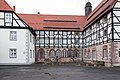
Former Benedictine monastery of St. Blasii | The monastery was initially set up as a canon monastery between 1083 and 1101. Between 1103 and 1117 it was converted into a Benedictine monastery. The monastery was named after Blasius von Sebaste . Construction of the collegiate church began in 1487, but was no longer completed after the Reformation was introduced in 1541. In the middle of the 16th century the monastery began to disintegrate. In the period that followed, larger parts of the masonry were removed due to the dilapidation. The oldest parts of the sacristy, which is now used as a chapel, and the so-called Liberey, today used as a wedding room, have been preserved. To the west of the chapel there is a three-storey wing with a massive basement and two upper storeys with torches, probably from the late 18th century. To the north is a similarly designed central wing between the chapel and the manor house. In it are the remains of the cloister. The so-called grave chapel St. Nicolai from the second half of the 15th century joins the central wing to the east. The two-storey solid construction of the so-called manor house forms the northern end of the building complex. The St. Blasien complex, which has been preserved to this day, was taken over by the city of Northeim in 1975 and extensively restored in 1979. Protected according to § 3 (2) NDSchG |
 More pictures |

View from the east of the south wing, 2017

View from the west of the south wing, 2017
View from the west, view of rudiments of the cloister, 2017

View from the east of the so-called burial chapel, 2017

View from the west of the so-called manor house, 2017


wide street
The Breite Strasse 1-11 group consists of three-storey eaves houses, most of which date from the mid-19th century.
| location | designation | description |
ID |
image |
|---|---|---|---|---|
| Latitude 1 51 ° 42 ′ 19 ″ N, 9 ° 59 ′ 57 ″ E |
Residential building | Protected according to § 3 (3) NDSchG |
 More pictures |
|
| Latitude 2 51 ° 42 ′ 19 ″ N, 9 ° 59 ′ 57 ″ E |
Residential building | Protected according to § 3 (3) NDSchG |
 More pictures |
|
| Latitude 3 51 ° 42 ′ 19 ″ N, 9 ° 59 ′ 58 ″ E |
Residential building | Protected according to § 3 (3) NDSchG |
 More pictures |
|
| Latitude 4 51 ° 42 ′ 19 ″ N, 9 ° 59 ′ 58 ″ E |
Residential building | Protected according to § 3 (3) NDSchG |
 More pictures |
|
| Latitude 5 51 ° 42 ′ 19 ″ N, 9 ° 59 ′ 58 ″ E |
Residential building | Protected according to § 3 (3) NDSchG |
More pictures |
|
| Latitude 6 51 ° 42 ′ 23 ″ N, 9 ° 59 ′ 59 ″ E |
Residential building | Protected according to § 3 (3) NDSchG |
 More pictures |
|
| Latitude 7 51 ° 42 ′ 19 ″ N, 10 ° 0 ′ 0 ″ E |
Residential building | Three-storey post -storey building from 1832 Protected according to § 3 (3) NDSchG |
 More pictures |
|
| Latitude 8 51 ° 42 ′ 19 ″ N, 10 ° 0 ′ 0 ″ E |
Residential building | Protected according to § 3 (3) NDSchG |
 More pictures |
|
| Latitude 9 51 ° 42 ′ 19 ″ N, 10 ° 0 ′ 1 ″ E |
Residential building | Protected according to § 3 (3) NDSchG |
More pictures |
|
| Latitude 10 51 ° 42 ′ 19 ″ N, 10 ° 0 ′ 1 ″ E |
Residential building | Protected according to § 3 (3) NDSchG |
 More pictures |
|
| Latitude 11 51 ° 42 ′ 19 ″ N, 10 ° 0 ′ 1 ″ E |
Residential building | Protected according to § 3 (3) NDSchG |
 More pictures |
The street section Breite Straße 12-35 is more heterogeneous than the previous section.
| location | designation | description |
ID |
image |
|---|---|---|---|---|
| Latitude 12 51 ° 42 ′ 20 ″ N, 10 ° 0 ′ 2 ″ E |
Residential building | Protected according to § 3 (3) NDSchG |
 More pictures |
|
| Latitude 13 51 ° 42 ′ 20 ″ N, 10 ° 0 ′ 3 ″ E |
Residential building | Protected according to § 3 (3) NDSchG |
 More pictures |
|
| Latitude 14 51 ° 42 ′ 20 ″ N, 10 ° 0 ′ 3 ″ E |
Residential building | Protected according to § 3 (3) NDSchG |
 More pictures |
|
| Latitude 15 51 ° 42 ′ 20 ″ N, 10 ° 0 ′ 3 ″ E |
Residential building | Protected according to § 3 (2) NDSchG |
 More pictures |
|
| Latitude 16 51 ° 42 ′ 20 ″ N, 10 ° 0 ′ 3 ″ E |
Residential building | The house was built in the second half of the 18th century. It is a two-storey, eaves-standing house with a dwelling that takes up almost the entire width of the house. Protected according to § 3 (2) NDSchG |
 More pictures |
|
| Latitude 17 51 ° 42 ′ 20 ″ N, 10 ° 0 ′ 4 ″ E |
Residential building | Protected according to § 3 (3) NDSchG |
 More pictures |
|
| Latitude 18 51 ° 42 ′ 20 ″ N, 10 ° 0 ′ 5 ″ E |
Residential building | Protected according to § 3 (3) NDSchG |
 More pictures |
|
| Latitude 19 51 ° 42 ′ 20 ″ N, 10 ° 0 ′ 6 ″ E |
Residential building | Protected according to § 3 (3) NDSchG |
 More pictures |
|
| Latitude 20 51 ° 42 ′ 20 ″ N, 10 ° 0 ′ 6 ″ E |
Residential building | Protected according to § 3 (3) NDSchG |
 More pictures |
|
| Latitude 21 51 ° 42 ′ 21 ″ N, 10 ° 0 ′ 7 ″ E |
Residential building | Protected according to § 3 (3) NDSchG |
 More pictures |
|
| Latitude 22 51 ° 42 ′ 21 ″ N, 10 ° 0 ′ 7 ″ E |
Residential building | Protected according to § 3 (3) NDSchG |
 More pictures |
|
| Latitude 22 51 ° 42 ′ 17 ″ N, 9 ° 59 ′ 53 ″ E |
Outbuildings | Protected according to § 3 (2) NDSchG |
 More pictures |
|
| Latitude 23 51 ° 42 ′ 21 ″ N, 10 ° 0 ′ 7 ″ E |
Residential building | Protected according to § 3 (3) NDSchG |
 More pictures |
|
| Latitude 24 51 ° 42 ′ 21 ″ N, 10 ° 0 ′ 8 ″ E |
hotel | Protected according to § 3 (3) NDSchG |
 More pictures |
|
| Latitude 25 51 ° 42 ′ 21 ″ N, 10 ° 0 ′ 8 ″ E |
Residential building | Protected according to § 3 (3) NDSchG |
 More pictures |
|
| Latitude 26 51 ° 42 ′ 21 ″ N, 10 ° 0 ′ 9 ″ E |
Residential building | Protected according to § 3 (3) NDSchG |
 More pictures |
|
| Latitude 27 51 ° 42 ′ 21 ″ N, 10 ° 0 ′ 9 ″ E |
Residential building | Protected according to § 3 (3) NDSchG |
More pictures |
|
| Latitude 28 51 ° 42 ′ 21 ″ N, 10 ° 0 ′ 10 ″ E |
Residential building | Protected according to § 3 (3) NDSchG |
 More pictures |
|
| Latitude 29 51 ° 42 ′ 21 ″ N, 10 ° 0 ′ 10 ″ E |
Residential building | Protected according to § 3 (3) NDSchG |
 More pictures |
|
| Latitude 30 51 ° 42 ′ 21 ″ N, 10 ° 0 ′ 10 ″ E |
Residential building | Protected according to § 3 (3) NDSchG |
 More pictures |
|
| Latitude 31 51 ° 42 ′ 22 ″ N, 10 ° 0 ′ 11 ″ E |
Residential building | Protected according to § 3 (3) NDSchG |
 More pictures |
|
| Latitude 32 51 ° 42 ′ 21 ″ N, 10 ° 0 ′ 11 ″ E |
Residential building | Protected according to § 3 (3) NDSchG |
 More pictures |
|
| Latitude 33 51 ° 42 ′ 22 ″ N, 10 ° 0 ′ 12 ″ E |
Residential building | Protected according to § 3 (2) NDSchG |
 More pictures |
|
| Latitude 34 51 ° 42 ′ 22 ″ N, 10 ° 0 ′ 12 ″ E |
Residential building | Protected according to § 3 (3) NDSchG |
 More pictures |
|
| Latitude 35 51 ° 42 ′ 21 ″ N, 10 ° 0 ′ 12 ″ E |
Residential building | Protected according to § 3 (3) NDSchG |
 More pictures |
The street section between Breite Straße 36 and 54 contains some quality buildings.
| location | designation | description |
ID |
image |
|---|---|---|---|---|
| Latitude 36 51 ° 42 ′ 22 ″ N, 10 ° 0 ′ 11 ″ E |
pharmacy | Three-storey solid building in a corner, built for butcher H. Robert in 1908. Protected according to § 3 (3) NDSchG |
 More pictures |
|
| Latitude 37 51 ° 42 ′ 8 ″ N, 10 ° 0 ′ 11 ″ E |
Residential building, so-called Kassebeerscheshaus | Representative upstairs post-storey building from 1566; Around 1600 a four-axis Utlucht was presented in the right front of the house. Protected according to § 3 (2) NDSchG |
 More pictures |
|
| Latitude 38 51 ° 42 ′ 22 ″ N, 10 ° 0 ′ 10 ″ E |
Inn | Elongated eaves half-timbered building, built in 1722 as a Fuhrmannsgasthof, called "Golden Lowe" since 1840, ground floor massively renewed Protected according to § 3 (2) NDSchG |
 More pictures |
|
| Latitude 39 51 ° 42 ′ 22 ″ N, 10 ° 0 ′ 9 ″ E |
Residential building | Protected according to § 3 (3) NDSchG |
 More pictures |
|
| Latitude 40 51 ° 42 ′ 22 ″ N, 10 ° 0 ′ 9 ″ E |
Residential building | Protected according to § 3 (3) NDSchG |
 More pictures |
|
| Latitude 41 51 ° 42 ′ 22 ″ N, 10 ° 0 ′ 8 ″ E |
Residential building | Multi-storey stand construction, around 1600, ground floor gutted Protected according to § 3 (2) NDSchG |
 More pictures |
|
| Latitude 42 51 ° 42 ′ 22 ″ N, 10 ° 0 ′ 8 ″ E |
Residential house, former Plessian feudal house | Multi-storey stand construction, around 1600, ground floor gutted Protected according to § 3 (2) NDSchG |
 More pictures |
|
| Latitude 43 51 ° 42 ′ 22 ″ N, 10 ° 0 ′ 8 ″ E |
Residential building | Protected according to § 3 (3) NDSchG |
 More pictures |
|
| Latitude 44 51 ° 42 ′ 21 ″ N, 10 ° 0 ′ 7 ″ E |
Residential building | Multi-story stand construction Protected according to § 3 (2) NDSchG |
 More pictures |
|
| Latitude 45 51 ° 42 ′ 21 ″ N, 10 ° 0 ′ 7 ″ E |
Residential building | Multi-storey stand construction, probably built around 1600 Protected according to § 3 (2) NDSchG |
 More pictures |
|
| Latitude 46 51 ° 42 ′ 21 ″ N, 10 ° 0 ′ 6 ″ E |
Residential building | Protected according to § 3 (3) NDSchG |
 More pictures |
|
| Latitude 47 51 ° 42 ′ 21 ″ N, 10 ° 0 ′ 6 ″ E |
Residential building | Protected according to § 3 (3) NDSchG |
 More pictures |
|
| Latitude 48 51 ° 42 ′ 21 ″ N, 10 ° 0 ′ 6 ″ E |
Residential building | Two-storey half-timbered building, about 1700 Protected according to § 3 (3) NDSchG |
 More pictures |
|
| Latitude 49 51 ° 42 ′ 21 ″ N, 10 ° 0 ′ 5 ″ E |
Residential building | Six-tier post-storey building, mid-16th century, significantly changed Protected according to § 3 (2) NDSchG |
 More pictures |
|
| Latitude 50 51 ° 42 ′ 21 ″ N, 10 ° 0 ′ 5 ″ E |
Residential and commercial building | Solid brick building, erected in 1910 for butcher Karl Zick. Protected according to § 3 (3) NDSchG |
 More pictures |
|
| Latitude 51 51 ° 42 ′ 21 ″ N, 10 ° 0 ′ 4 ″ E |
Residential and commercial building | Solid brick building, erected in 1895 for innkeeper Wilhelm Müller Protected according to § 3 (3) NDSchG |
 More pictures |
|
| Latitude 52 51 ° 42 ′ 21 ″ N, 10 ° 0 ′ 4 ″ E |
Residential building | Protected according to § 3 (3) NDSchG |
 More pictures |
|
| Latitude 53 51 ° 42 ′ 21 ″ N, 10 ° 0 ′ 3 ″ E |
Residential building | Protected according to § 3 (3) NDSchG |
 More pictures |
|
| Latitude 54 51 ° 42 ′ 21 ″ N, 10 ° 0 ′ 3 ″ E |
Residential building | Three-axis post -storey construction Protected according to § 3 (2) NDSchG |
 More pictures |
The row of houses at Breite Straße 55-65 is the result of the reconstruction after the town fire in 1832, in which the town hall and the old buildings in its vicinity were destroyed by flames.
| location | designation | description |
ID |
image |
|---|---|---|---|---|
| Latitude 55 51 ° 42 ′ 20 ″ N, 10 ° 0 ′ 0 ″ E |
Residential building | Protected according to § 3 (3) NDSchG |
 More pictures |
|
| Latitude 56 51 ° 42 ′ 20 ″ N, 10 ° 0 ′ 0 ″ E |
Residential building | Protected according to § 3 (3) NDSchG |
 More pictures |
|
| Latitude 57 51 ° 42 ′ 20 ″ N, 10 ° 0 ′ 0 ″ E |
Residential building | Protected according to § 3 (3) NDSchG |
More pictures |
|
| Latitude 58 51 ° 42 ′ 20 ″ N, 9 ° 59 ′ 59 ″ E |
Residential building | Protected according to § 3 (3) NDSchG |
 More pictures |
|
| Latitude 59 51 ° 42 ′ 20 ″ N, 9 ° 59 ′ 59 ″ E |
Hotel sun | Stately half-timbered building, erected in 1832 as a replacement for the building that burned down at the time for Johann Georg Sonne Protected according to § 3 (2) NDSchG |
 More pictures |
|
| Latitude 60 51 ° 42 ′ 20 ″ N, 9 ° 59 ′ 57 ″ E |
Residential building | Protected according to § 3 (3) NDSchG |
 More pictures |
|
| Latitude 61 51 ° 42 ′ 19 ″ N, 9 ° 59 ′ 57 ″ E |
Residential building | Protected according to § 3 (3) NDSchG |
 More pictures |
|
| Latitude 62 51 ° 42 ′ 19 ″ N, 9 ° 59 ′ 56 ″ E |
Residential building | Protected according to § 3 (3) NDSchG |
 More pictures |
|
| Latitude 63 51 ° 42 ′ 19 ″ N, 9 ° 59 ′ 56 ″ E |
Residential building | Protected according to § 3 (3) NDSchG |
 More pictures |
|
| Latitude 64 51 ° 42 ′ 19 ″ N, 9 ° 59 ′ 56 ″ E |
Residential building | Protected according to § 3 (3) NDSchG |
 More pictures |
|
| Latitude 65 51 ° 42 ′ 19 ″ N, 9 ° 59 ′ 56 ″ E |
Residential and commercial building | Three-storey brick building with ashlar structure, built in 1900 by master bricklayer Frankenberg for banker Adolf Müller, replacement building for the Bonehauer Gildehaus, which was destroyed by fire in 1832, protected according to § 3 (3) NDSchG |
 More pictures |
Schaupenstiel
The southern row of houses, Schaupenstiel 1-6, was destroyed by fire in 1821 and replaced by.
| location | designation | description |
ID |
image |
|---|---|---|---|---|
| Schaupenstiel 1 51 ° 42 ′ 22 ″ N, 10 ° 0 ′ 13 ″ E |
Residential building | Protected according to § 3 (3) NDSchG |
More pictures |
|
| Schaupenstiel 2 51 ° 42 ′ 22 ″ N, 10 ° 0 ′ 13 ″ E |
Residential building | Protected according to § 3 (3) NDSchG |
 More pictures |
|
| Schaupenstiel 3 51 ° 42 ′ 22 ″ N, 10 ° 0 ′ 14 ″ E |
Residential building | Protected according to § 3 (3) NDSchG |
More pictures |
|
| Schaupenstiel 4 51 ° 42 ′ 22 ″ N, 10 ° 0 ′ 13 ″ E |
Residential building | Protected according to § 3 (3) NDSchG |
 More pictures |
|
| Schaupenstiel 5 51 ° 42 ′ 22 ″ N, 10 ° 0 ′ 14 ″ E |
Residential building | Protected according to § 3 (3) NDSchG |
More pictures |
|
| Schaupenstiel 6 51 ° 42 ′ 21 ″ N, 10 ° 0 ′ 13 ″ E |
Residential building | Protected according to § 3 (3) NDSchG |
 More pictures |
|
| Schaupenstiel 7 51 ° 42 ′ 22 ″ N, 10 ° 0 ′ 15 ″ E |
Residential building | Protected according to § 3 (3) NDSchG |
 More pictures |
|
| Schaupenstiel 8 51 ° 42 ′ 21 ″ N, 10 ° 0 ′ 14 ″ E |
Residential building | Two-storey, eaves half-timbered building, shortly after 1700, with decorative shapes that are unique in Nordheim (diamond-shaped decorative struts, K-struts and "Wilder Mann") Protected according to § 3 (2) NDSchG |
 More pictures |
|
| Schaupenstiel 9 51 ° 42 ′ 22 ″ N, 10 ° 0 ′ 16 ″ E |
Residential building | Half-timbered building with studs extending from the ground floor to the mezzanine, early 16th century Protected according to § 3 (2) NDSchG |
 More pictures |
|
| Schaupenstiel 10 51 ° 42 ′ 21 ″ N, 10 ° 0 ′ 14 ″ E |
Residential building | Protected according to § 3 (3) NDSchG |
 More pictures |
|
| Schaupenstiel 11 51 ° 42 ′ 22 ″ N, 10 ° 0 ′ 16 ″ E |
Residential building | Protected according to § 3 (3) NDSchG |
 More pictures |
|
| Schaupenstiel 12 51 ° 42 ′ 21 ″ N, 10 ° 0 ′ 14 ″ E |
Residential building | Protected according to § 3 (3) NDSchG |
 More pictures |
|
| Schaupenstiel 13 51 ° 42 ′ 22 ″ N, 10 ° 0 ′ 16 ″ E |
Residential building | Protected according to § 3 (3) NDSchG |
 More pictures |
|
| Schaupenstiel 15 51 ° 42 ′ 23 ″ N, 10 ° 0 ′ 17 ″ E |
Residential house, so-called Corvinius House | Nine-bonded eaves half-timbered house in post-storey construction, early 16th century Protected according to § 3 (2) NDSchG |
 More pictures |
|
| Schaupenstiel 16 51 ° 42 ′ 22 ″ N, 10 ° 0 ′ 15 ″ E |
Residential building | Protected according to § 3 (3) NDSchG |
 More pictures |
|
| Schaupenstiel 18 51 ° 42 ′ 21 ″ N, 10 ° 0 ′ 15 ″ E |
Residential building | Protected according to § 3 (3) NDSchG |
 More pictures |
|
| Schaupenstiel 20 51 ° 42 ′ 22 ″ N, 10 ° 0 ′ 17 ″ E |
Former brewery | Protected according to § 3 (3) NDSchG |
 More pictures |
market
The market square changed its appearance a lot after the two devastating city fires in 1832 and 1832. On 28/29. May 1832 a total of 33 residential buildings and 43 outbuildings were destroyed, including the 16th century town hall, which stood on the south side of the market. On October 6, 1892, a fire broke out in the house at Breite Strasse 52, which destroyed the eastern side of the market (Markt 1-11). This area was deliberately not rebuilt in half-timbered, but in solid construction with brick, quarry stone and stone.
| location | designation | description |
ID |
image |
|---|---|---|---|---|
| Markt 1 51 ° 42 ′ 21 ″ N, 10 ° 0 ′ 2 ″ E |
Residential and commercial building | Protected according to § 3 (3) NDSchG |
 More pictures |
|
| Market 2 51 ° 42 ′ 21 ″ N, 10 ° 0 ′ 2 ″ E |
Residential and commercial building | Protected according to § 3 (3) NDSchG |
 More pictures |
|
| Markt 3 51 ° 42 ′ 21 ″ N, 10 ° 0 ′ 2 ″ E |
Residential and commercial building | Protected according to § 3 (3) NDSchG |
More pictures |
|
| Markt 4 51 ° 42 ′ 22 ″ N, 10 ° 0 ′ 2 ″ E |
Residential and commercial building | The residential and commercial building was built in 1894. It is a three-storey, eaves-standing house with a gable roof and a high dwelling. Protected according to § 3 (3) NDSchG |
 More pictures |
|
| Markt 5 51 ° 42 ′ 22 ″ N, 10 ° 0 ′ 2 ″ E |
Residential and commercial building | Protected according to § 3 (3) NDSchG |
 More pictures |
|
| Markt 6 51 ° 42 ′ 22 ″ N, 10 ° 0 ′ 2 ″ E |
Residential and commercial building | Protected according to § 3 (3) NDSchG |
 More pictures |
|
| Markt 7 51 ° 42 ′ 22 ″ N, 10 ° 0 ′ 2 ″ E |
Residential commercial building | The house was built in 1893. Protected according to § 3 (3) NDSchG |
 More pictures |
|
| Markt 8 51 ° 42 ′ 22 ″ N, 10 ° 0 ′ 2 ″ E |
Residential and commercial building | 1893 is marked on an inscription as the year of construction. It is a three-storey, eaves-standing residential building with distinctive dwarf houses. Protected according to § 3 (3) NDSchG |
 More pictures |
|
| Markt 9 51 ° 42 ′ 23 ″ N, 10 ° 0 ′ 2 ″ E |
Residential building | Protected according to § 3 (3) NDSchG |
 More pictures |
|
| Market 10 51 ° 42 ′ 23 ″ N, 10 ° 0 ′ 2 ″ E |
movie theater | Three-storey brick building, built for innkeeper D. Heidelmann around 1893, facade on the ground floor changed in 1923 and 1936 for the cinema extension Protected according to § 3 (3) NDSchG |
More pictures |
|
| Markt 11 51 ° 42 ′ 24 ″ N, 10 ° 0 ′ 2 ″ E |
Residential commercial building | Three-storey corner house in brick masonry, with corner-concreting bay window, built for businessman J. Bruns in 1893. Protected according to § 3 (3) NDSchG |
 More pictures |
| location | designation | description |
ID |
image |
|---|---|---|---|---|
| Markt 14 51 ° 42 ′ 22 ″ N, 10 ° 0 ′ 0 ″ E |
Former market chapel St. Fabian and Sebastian and Hauptwache | The market chapel was built from 1354. It is reminiscent of the plague that raged in 1346. In the 18th century the main guard should be moved to the chapel. After resistance from the mayor, a main guard was added to the south of the chapel in 1734. Protected according to § 3 (2) NDSchG |
 More pictures |
The reconstructions of the row of houses Am Markt 18-21 from the first half of the 19th century consist of three-story half-timbered buildings.
| location | designation | description |
ID |
image |
|---|---|---|---|---|
| Markt 18 51 ° 42 ′ 22 ″ N, 10 ° 0 ′ 0 ″ E |
Residential building | Protected according to § 3 (3) NDSchG |
 More pictures |
|
| Markt 19 51 ° 42 ′ 22 ″ N, 10 ° 0 ′ 0 ″ E |
Residential building | Protected according to § 3 (3) NDSchG |
 More pictures |
|
| Markt 20 51 ° 42 ′ 21 ″ N, 10 ° 0 ′ 0 ″ E |
Residential building | Protected according to § 3 (3) NDSchG |
 More pictures |
|
| Market 21 51 ° 42 ′ 21 ″ N, 10 ° 0 ′ 0 ″ E |
Residential building | Protected according to § 3 (3) NDSchG |
 More pictures |
Duck market
| location | designation | description |
ID |
image |
|---|---|---|---|---|
| Entenmarkt 2 51 ° 42 ′ 24 ″ N, 10 ° 0 ′ 8 ″ E |
So-called preacher's house | Two-storey half-timbered building with a half-hipped roof from 1779. An outside staircase opens up the house from the west. Protected according to § 3 (2) NDSchG |
 More pictures |
|
| Entenmarkt 3 51 ° 42 ′ 24 ″ N, 10 ° 0 ′ 8 ″ E |
So-called Rumannsches House | Two-storey eaves half-timbered structure with a double flight of stairs and was built from 1768 to 1770 by the senior bailiff Johann Levin Christoph Rumann, including a medieval stone chamber. Before that there was a brewery on the site. From 1842 to 1847 the town hall was located in the house. Protected according to § 3 (2) NDSchG |
 More pictures |
|
| Entenmarkt 3 51 ° 42 ′ 24 ″ N, 10 ° 0 ′ 8 ″ E |
Secret Annex | Protected according to § 3 (2) NDSchG |
 More pictures |
|
| Duck Market 4 51 ° 42 ′ 24 ″ N, 10 ° 0 ′ 6 ″ E |
Residential building | Single-storey half-timbered building Protected according to § 3 (2) NDSchG |
 More pictures |
|
| Duck Market 14 51 ° 42 ′ 24 ″ N, 10 ° 0 ′ 5 ″ E |
Residential building | The house on the corner of Rathausgasse was built at the end of the 15th century. It is a gable-independent half-timbered house. In 1986 it was renovated. Protected according to § 3 (2) NDSchG |
 More pictures |
|
| Duck Market 15 51 ° 42 ′ 23 ″ N, 10 ° 0 ′ 5 ″ E |
Agricultural bourgeoisie | The arable bourgeois house was built in 1708. It is a two-story, eaves-standing house. The upper story protrudes. The inscription on the upper floor sill reads: “EVERYTHING THAT I DO AND IN THE BEGINNING IS DONE IN THE TAKE OF JESUS CHRIST / WHO STAND FOR ME BEY EARLY AND SPATH UNTIL ALL MY THING HAS AN END”. Protected according to § 3 (2) NDSchG |
 More pictures |
church Square
| location | designation | description |
ID |
image |
|---|---|---|---|---|
| Kirchplatz 51 ° 42 ′ 19 ″ N, 10 ° 0 ′ 11 ″ E |
Evangelical Lutheran Church of St. Sixti | Hall church with 5/8 choir closure; important organ by Johann Wilhelm Gloger from the first third of the 18th century. Protected according to § 3 (2) NDSchG |
 More pictures |
|
| Kirchplatz 1 51 ° 42 ′ 20 ″ N, 10 ° 0 ′ 10 ″ E |
Residential building | Protected according to § 3 (3) NDSchG |
 More pictures |
|
| Kirchplatz 2 51 ° 42 ′ 20 ″ N, 10 ° 0 ′ 10 ″ E |
Residential building | This half-timbered house was built at the beginning of the 19th century. Protected according to § 3 (3) NDSchG |
 More pictures |
|
| Kirchplatz 3 51 ° 42 ′ 20 ″ N, 10 ° 0 ′ 10 ″ E |
Residential house, former organist house | The house has three axes and two floors. It was built in the early 18th century. Protected according to § 3 (3) NDSchG |
 More pictures |
|
| Kirchplatz 4 51 ° 42 ′ 20 ″ N, 10 ° 0 ′ 11 ″ E |
Residential building | The house was built in the early 18th century. Protected according to § 3 (3) NDSchG |
 More pictures |
|
| Kirchplatz 5 51 ° 42 ′ 20 ″ N, 10 ° 0 ′ 12 ″ E |
Residential building | Successor to the combing house destroyed by the town fire in 1821, early 19th century Protected according to § 3 (3) NDSchG |
 More pictures |
|
| Kirchplatz 6 51 ° 42 ′ 21 ″ N, 10 ° 0 ′ 12 ″ E |
Residential building | Successor to the predecessor building destroyed by the fire in 1821 Protected according to § 3 (3) NDSchG |
 More pictures |
|
| Kirchplatz 7 51 ° 42 ′ 20 ″ N, 10 ° 0 ′ 12 ″ E |
Residential building | The former preacher's widow's house was probably built at the end of the 17th century. It is an eaves, two-story house with a gable roof. Due to its transverse location to the square, it closes off the square and thus shapes the appearance of the church square. Protected according to § 3 (2) NDSchG |
 More pictures |
|
| Kirchplatz 8 51 ° 42 ′ 20 ″ N, 10 ° 0 ′ 13 ″ E |
Residential building | Behind the house at Kirchplatz 7 is the former Konrektorhaus. It is a free-standing half-timbered house with a gable roof. The house is uninhabited and is falling apart (as of July 2013, November 2017). Protected according to § 3 (2) NDSchG |
 More pictures |
|
| Kirchstrasse 6 51 ° 42 ′ 20 ″ N, 10 ° 0 ′ 9 ″ E |
Residential house, former organist house | Late Gothic post-storey building on the eaves facing the church square Protected according to § 3 (2) NDSchG |
 More pictures |
Mühlenstrasse
The southern part was largely destroyed in the town fire in 1832. As a group of buildings, the entire Mühlenstrasse is of monumental value.
| location | designation | description |
ID |
image |
|---|---|---|---|---|
| Mühlenstrasse 1 51 ° 42 ′ 24 ″ N, 10 ° 0 ′ 2 ″ E |
Residential building | Protected according to § 3 (2) NDSchG |
 More pictures |
|
| Mühlenstrasse 1 51 ° 42 ′ 24 ″ N, 10 ° 0 ′ 3 ″ E |
Secret annexe, stone chamber | Protected according to § 3 (2) NDSchG |
 More pictures |
|
| Mühlenstrasse 2 51 ° 42 ′ 24 ″ N, 10 ° 0 ′ 2 ″ E |
Residential building | Protected according to § 3 (3) NDSchG | ||
| Mühlenstrasse 3 51 ° 42 ′ 25 ″ N, 10 ° 0 ′ 2 ″ E |
Residential building | Protected according to § 3 (3) NDSchG | ||
| Mühlenstrasse 4 51 ° 42 ′ 25 ″ N, 10 ° 0 ′ 2 ″ E |
Residential building | Protected according to § 3 (3) NDSchG | ||
| Mühlenstrasse 5 51 ° 42 ′ 25 ″ N, 10 ° 0 ′ 2 ″ E |
Residential building | Protected according to § 3 (3) NDSchG | ||
| Mühlenstrasse 6 51 ° 42 ′ 25 ″ N, 10 ° 0 ′ 2 ″ E |
Residential building | Protected according to § 3 (3) NDSchG | ||
| Mühlenstrasse 7 51 ° 42 ′ 26 ″ N, 10 ° 0 ′ 2 ″ E |
Residential building | Protected according to § 3 (3) NDSchG | ||
| Mühlenstrasse 8 51 ° 42 ′ 26 ″ N, 10 ° 0 ′ 2 ″ E |
Residential building | Protected according to § 3 (3) NDSchG | ||
| Mühlenstrasse 9 51 ° 42 ′ 27 ″ N, 10 ° 0 ′ 2 ″ E |
Residential building | Protected according to § 3 (3) NDSchG | ||
| Mühlenstrasse 10 51 ° 42 ′ 27 ″ N, 10 ° 0 ′ 2 ″ E |
Residential building | Protected according to § 3 (3) NDSchG | ||
| Mühlenstrasse 11 51 ° 42 ′ 27 ″ N, 10 ° 0 ′ 2 ″ E |
Residential building | Protected according to § 3 (3) NDSchG | ||
| Mühlenstrasse 12 51 ° 42 ′ 28 ″ N, 10 ° 0 ′ 2 ″ E |
Residential building | Protected according to § 3 (3) NDSchG | ||
| Mühlenstrasse 13 51 ° 42 ′ 28 ″ N, 10 ° 0 ′ 2 ″ E |
Residential building | Protected according to § 3 (3) NDSchG |
 More pictures |
|
| Mühlenstrasse 14 51 ° 42 ′ 29 ″ N, 10 ° 0 ′ 2 ″ E |
Residential building | Protected according to § 3 (3) NDSchG | ||
| Mühlenstrasse 15 51 ° 42 ′ 29 ″ N, 10 ° 0 ′ 2 ″ E |
Residential building, former gatekeeper house | Protected according to § 3 (3) NDSchG | ||
| Mühlenstrasse 16, former gatehouse 51 ° 42 ′ 29 ″ N, 10 ° 0 ′ 2 ″ E |
Residential building | Protected according to § 3 (3) NDSchG | ||
| Mühlenstraße 17, former gatekeeper house, |
Residential building | Protected according to § 3 (3) NDSchG | ||
| Mühlenstrasse 19 51 ° 42 ′ 29 ″ N, 10 ° 0 ′ 1 ″ E |
Residential building | Half-timbered building, built in 1778 after the gate system was demolished. Protected according to § 3 (3) NDSchG |
 More pictures |
|
| Mühlenstrasse 20 51 ° 42 ′ 29 ″ N, 10 ° 0 ′ 1 ″ E |
Residential building | Protected according to § 3 (3) NDSchG | ||
| Mühlenstrasse 21 51 ° 42 ′ 28 ″ N, 10 ° 0 ′ 1 ″ E |
Residential building | Protected according to § 3 (3) NDSchG |
 More pictures |
|
| Mühlenstrasse 22 51 ° 42 ′ 28 ″ N, 10 ° 0 ′ 1 ″ E |
Residential building | Protected according to § 3 (3) NDSchG | ||
| Mühlenstrasse 23 51 ° 42 ′ 28 ″ N, 10 ° 0 ′ 1 ″ E |
Residential and commercial building | Protected according to § 3 (3) NDSchG | ||
| Mühlenstrasse 24 51 ° 42 ′ 27 ″ N, 10 ° 0 ′ 1 ″ E |
Residential and commercial building | Protected according to § 3 (3) NDSchG |
 More pictures |
|
| Mühlenstrasse 25 51 ° 42 ′ 27 ″ N, 10 ° 0 ′ 1 ″ E |
Residential and commercial building | Protected according to § 3 (3) NDSchG |
 More pictures |
|
| Mühlenstrasse 26 51 ° 42 ′ 26 ″ N, 10 ° 0 ′ 1 ″ E |
Residential and commercial building | Protected according to § 3 (3) NDSchG |
 More pictures |
|
| Mühlenstrasse 27 51 ° 42 ′ 26 ″ N, 10 ° 0 ′ 1 ″ E |
Residential and commercial building | Protected according to § 3 (3) NDSchG |
 More pictures |
|
| Mühlenstrasse 28 51 ° 42 ′ 26 ″ N, 10 ° 0 ′ 1 ″ E |
Residential and commercial building | Protected according to § 3 (3) NDSchG |

|
|
| Mühlenstrasse 29 51 ° 42 ′ 25 ″ N, 10 ° 0 ′ 1 ″ E |
Residential and commercial building | Protected according to § 3 (3) NDSchG |
|
|
| Mühlenstrasse 30 51 ° 42 ′ 25 ″ N, 10 ° 0 ′ 1 ″ E |
Residential and commercial building | Protected according to § 3 (3) NDSchG |
|
|
| Mühlenstrasse 31 51 ° 42 ′ 25 ″ N, 10 ° 0 ′ 1 ″ E |
Residential and commercial building | Protected according to § 3 (3) NDSchG |
|
|
| Mühlenstrasse 32 51 ° 42 ′ 24 ″ N, 10 ° 0 ′ 1 ″ E |
Residential and commercial building | Protected according to § 3 (3) NDSchG |
 More pictures |
Häuserstraße
| location | designation | description |
ID |
image |
|---|---|---|---|---|
| Häuserstrasse 1 51 ° 42 ′ 23 ″ N, 10 ° 0 ′ 13 ″ E |
Residential building | The house is located on the corner of Häuserstraße / Schaupenstiel. The house was built in 1772. It is a three-storey eaves half-timbered house with seven axes. In front of the entrance in the central axis there is a two-flight staircase. Protected according to § 3 (2) NDSchG |
 More pictures |
|
| Häuserstraße 2 51 ° 42 ′ 23 ″ N, 10 ° 0 ′ 12 ″ E |
Residential building | Stair-storey building, probably from the first half of the 16th century, the value of the testimony considerably impaired by the complete gutting of the ground floor Protected according to § 3 (2) NDSchG |
 More pictures |
|
| Häuserstraße 3/4 51 ° 42 ′ 23 ″ N, 10 ° 0 ′ 12 ″ E |
Residential building | Protected according to § 3 (3) NDSchG | ||
| Häuserstraße 5 51 ° 42 ′ 24 ″ N, 10 ° 0 ′ 12 ″ E |
Residential building | Half-timbered construction, 1708 Protected according to § 3 (3) NDSchG |
 More pictures |
|
| Häuserstraße 6 51 ° 42 ′ 24 ″ N, 10 ° 0 ′ 12 ″ E |
Residential building, former farm house | Stud construction of the first half of the 16th century, “repaired” in 1711 and “renewed” in 1953. Protected according to § 3 (2) NDSchG |
 More pictures |
|
| Häuserstraße 7 51 ° 42 ′ 24 ″ N, 10 ° 0 ′ 12 ″ E |
Residential building | Protected according to § 3 (3) NDSchG |
 More pictures |
|
| Häuserstraße 8 51 ° 42 ′ 25 ″ N, 10 ° 0 ′ 12 ″ E |
Residential building | Half-timbered building from the early 18th century. Protected according to § 3 (2) NDSchG |
 More pictures |
|
| Häuserstraße 9 51 ° 42 ′ 25 ″ N, 10 ° 0 ′ 12 ″ E |
Residential building | Stately eight-axle half-timbered building from the first third of the 16th century. Protected according to § 3 (2) NDSchG |
 More pictures |
|
| Häuserstraße 10 51 ° 42 ′ 25 ″ N, 10 ° 0 ′ 12 ″ E |
Residential building | Protected according to § 3 (3) NDSchG |
More pictures |
|
| Häuserstraße 11 51 ° 42 ′ 25 ″ N, 10 ° 0 ′ 12 ″ E |
Residential building | Protected according to § 3 (3) NDSchG |
More pictures |
|
| Häuserstraße 12 51 ° 42 ′ 26 ″ N, 10 ° 0 ′ 12 ″ E |
Residential building | Protected according to § 3 (3) NDSchG |
More pictures |
|
| Häuserstraße 13 51 ° 42 ′ 26 ″ N, 10 ° 0 ′ 12 ″ E |
Residential building | Protected according to § 3 (3) NDSchG |
 More pictures |
|
| Häuserstraße 14 51 ° 42 ′ 26 ″ N, 10 ° 0 ′ 11 ″ E |
Residential building | Half-timbered building from 1724 (building inscription) Protected according to § 3 (3) NDSchG |
 More pictures |
|
| Häuserstraße 15, former farm house 51 ° 42 ′ 26 ″ N, 10 ° 0 ′ 11 ″ E |
Residential building | Gable-independent stand-story building from 1587 Protected according to § 3 (2) NDSchG |
 More pictures |
|
| Häuserstrasse 16 51 ° 42 ′ 26 ″ N, 10 ° 0 ′ 11 ″ E |
Residential building | Protected according to § 3 (3) NDSchG |
 More pictures |
|
| Häuserstraße 17 51 ° 42 ′ 25 ″ N, 10 ° 0 ′ 11 ″ E |
Residential building | Protected according to § 3 (3) NDSchG |
 More pictures |
|
| Häuserstraße 18 51 ° 42 ′ 25 ″ N, 10 ° 0 ′ 11 ″ E |
Residential building | Protected according to § 3 (3) NDSchG |
 More pictures |
|
| Häuserstraße 19 51 ° 42 ′ 24 ″ N, 10 ° 0 ′ 11 ″ E |
Residential building | Protected according to § 3 (3) NDSchG |
 More pictures |
|
| Häuserstraße 20 51 ° 42 ′ 24 ″ N, 10 ° 0 ′ 11 ″ E |
Residential building | Partially original facade, lintel from 1591; Building almost completely redesigned in 1987. Protected according to § 3 (3) NDSchG |
 More pictures |
Wooden houses street
As a pure residential street, Holzhäuserstraße reflects the development history of house construction in Northeim from the 16th to the 19th century. The buildings in Holzhäuserstraße 1-28 are mostly two to three-storey eaves half-timbered buildings. The numerous old-fashioned multi-storey buildings in this street are striking. The houses at Holzhäuserstraße 29ff. are replacement buildings.
| location | designation | description |
ID |
image |
|---|---|---|---|---|
| Holzhäuserstraße 1 51 ° 42 ′ 26 ″ N, 10 ° 0 ′ 4 ″ E |
Residential building | Protected according to § 3 (3) NDSchG |
 More pictures |
|
| Holzhäuserstraße 2 51 ° 42 ′ 26 ″ N, 10 ° 0 ′ 4 ″ E |
Residential building | Multi-storey frame construction from the early 16th century Protected according to § 3 (2) NDSchG |
 More pictures |
|
| Holzhäuserstraße 3 51 ° 42 ′ 25 ″ N, 10 ° 0 ′ 4 ″ E |
Residential building | Multi-storey frame construction from the early 16th century Protected according to § 3 (2) NDSchG |
 More pictures |
|
| Holzhäuserstraße 4 51 ° 42 ′ 26 ″ N, 10 ° 0 ′ 5 ″ E |
Residential building | Protected according to § 3 (3) NDSchG |
 More pictures |
|
| Holzhäuserstraße 5 51 ° 42 ′ 25 ″ N, 10 ° 0 ′ 6 ″ E |
Residential building | Two-storey half-timbered building from 1721, modified in the 19th century. Protected according to § 3 (3) NDSchG |
 More pictures |
|
| Holzhäuserstraße 6 51 ° 42 ′ 25 ″ N, 10 ° 0 ′ 6 ″ E |
Residential building | Protected according to § 3 (3) NDSchG |
 More pictures |
|
| Holzhäuserstraße 7 51 ° 42 ′ 25 ″ N, 10 ° 0 ′ 6 ″ E |
Residential building | Stands-multi-storey building, 16th century, ground floor zone greatly changed Protected according to § 3 (2) NDSchG |
 More pictures |
|
| Holzhäuserstraße 8 51 ° 42 ′ 25 ″ N, 10 ° 0 ′ 7 ″ E |
Residential building | Stands-multi-storey building, 16th century, ground floor zone greatly changed Protected according to § 3 (2) NDSchG |
 More pictures |
|
| Holzhäuserstraße 9 51 ° 42 ′ 25 ″ N, 10 ° 0 ′ 7 ″ E |
Residential building | Protected according to § 3 (3) NDSchG | ||
| Holzhäuserstraße 10 51 ° 42 ′ 25 ″ N, 10 ° 0 ′ 7 ″ E |
Residential building | Stands-multi-storey building, 16th century Protected according to § 3 (2) NDSchG |
 More pictures |
|
| Holzhäuserstraße 11 51 ° 42 ′ 25 ″ N, 10 ° 0 ′ 8 ″ E |
Residential building | Stands-multi-storey building, 16th century Protected according to § 3 (2) NDSchG |
More pictures |
|
| Holzhäuserstraße 12 51 ° 42 ′ 25 ″ N, 10 ° 0 ′ 8 ″ E |
Residential building | Stands-multi-storey building, 16th century Protected according to § 3 (2) NDSchG |
More pictures |
|
| Holzhäuserstraße 13 51 ° 42 ′ 25 ″ N, 10 ° 0 ′ 8 ″ E |
Residential building | Elongated eaves, thirteen-axis half-timbered building, built after the Thirty Years' War Protected according to § 3 (3) NDSchG |
 More pictures |
|
| Holzhäuserstraße 14 51 ° 42 ′ 25 ″ N, 10 ° 0 ′ 9 ″ E |
Residential building | Protected according to § 3 (3) NDSchG |
More pictures |
|
| Holzhäuserstraße 15 51 ° 42 ′ 25 ″ N, 10 ° 0 ′ 10 ″ E |
Residential building | Protected according to § 3 (3) NDSchG |
More pictures |
|
| Holzhäuserstraße 16 51 ° 42 ′ 25 ″ N, 10 ° 0 ′ 10 ″ E |
Residential building | Protected according to § 3 (3) NDSchG |
 More pictures |
|
| Holzhäuserstraße 17 51 ° 42 ′ 26 ″ N, 10 ° 0 ′ 10 ″ E |
Residential building | Seven-pack timber-framed half-timbered building from 1714 Protected according to § 3 (3) NDSchG |
 More pictures |
|
| Holzhäuserstraße 18 51 ° 42 ′ 26 ″ N, 10 ° 0 ′ 10 ″ E |
Residential building | Half-timbered building from 1714 Protected according to § 3 (2) NDSchG |
 More pictures |
|
| Holzhäuserstraße 19 51 ° 42 ′ 26 ″ N, 10 ° 0 ′ 10 ″ E |
Residential building | Protected according to § 3 (2) NDSchG |
 More pictures |
|
| Holzhäuserstraße 20 51 ° 42 ′ 26 ″ N, 10 ° 0 ′ 9 ″ E |
Residential building | Half-timbered building, middle of the 19th century Protected according to § 3 (3) NDSchG |
 More pictures |
|
| Holzhäuserstraße 21 51 ° 42 ′ 26 ″ N, 10 ° 0 ′ 9 ″ E |
Residential building | Half-timbered building, middle of the 19th century Protected according to § 3 (3) NDSchG |
 More pictures |
|
| Holzhäuserstraße 22 51 ° 42 ′ 26 ″ N, 10 ° 0 ′ 9 ″ E |
Residential building | Half-timbered building, built after the Thirty Years' War Protected according to § 3 (3) NDSchG |
 More pictures |
|
| Holzhäuserstraße 23 51 ° 42 ′ 26 ″ N, 10 ° 0 ′ 8 ″ E |
Residential building | Protected according to § 3 (3) NDSchG |
 More pictures |
|
| Holzhäuserstraße 24 51 ° 42 ′ 26 ″ N, 10 ° 0 ′ 8 ″ E |
Residential building | Half-timbered building, built after the Thirty Years' War Protected according to § 3 (3) NDSchG |
 More pictures |
|
| Holzhäuserstraße 25 51 ° 42 ′ 26 ″ N, 10 ° 0 ′ 8 ″ E |
Residential building | Built in 1710 like the neighboring buildings as a typical arable house. Used as a cobbler's shop from 1800 to 1942, then residential building Protected according to § 3 (2) NDSchG |
 More pictures |
|
| Holzhäuserstraße 26 51 ° 42 ′ 26 ″ N, 10 ° 0 ′ 8 ″ E |
Residential building | Three-storey post -storey building with eaves, 16th century Protected according to § 3 (2) NDSchG |
 More pictures |
|
| Holzhäuserstraße 27 51 ° 42 ′ 26 ″ N, 10 ° 0 ′ 7 ″ E |
Residential building | Protected according to § 3 (3) NDSchG |
More pictures |
|
| Holzhäuserstraße 28 51 ° 42 ′ 26 ″ N, 10 ° 0 ′ 7 ″ E |
Residential building | Three-storey post -storey building with eaves, 16th century Protected according to § 3 (2) NDSchG |
 More pictures |
Hagenstrasse
The buildings at Hagenstrasse 10, 12 and 27 date back to the 16th century. Most of the houses date from the early 18th century.
| location | designation | description |
ID |
image |
|---|---|---|---|---|
| Short Street 7 51 ° 42 ′ 16 ″ N, 9 ° 59 ′ 56 ″ E |
Residential building | Protected according to § 3 (2) NDSchG |
 More pictures |
|
| Short Street 10 51 ° 42 ′ 17 ″ N, 9 ° 59 ′ 57 ″ E |
Residential building | Protected according to § 3 (3) NDSchG |
 More pictures |
|
| Hagenstrasse 3 51 ° 42 ′ 18 ″ N, 9 ° 59 ′ 59 ″ E |
Residential building | Protected according to § 3 (2) NDSchG |
 More pictures |
|
| Hagenstrasse 4 51 ° 42 ′ 17 ″ N, 9 ° 59 ′ 59 ″ E |
Residential building | Protected according to § 3 (3) NDSchG |
 More pictures |
|
| Hagenstrasse 5 51 ° 42 ′ 17 ″ N, 10 ° 0 ′ 0 ″ E |
Residential building | Protected according to § 3 (3) NDSchG | ||
| Hagenstrasse 6 51 ° 42 ′ 17 ″ N, 10 ° 0 ′ 0 ″ E |
Residential building | Protected according to § 3 (3) NDSchG |
 More pictures |
|
| Hagenstrasse 7 51 ° 42 ′ 17 ″ N, 10 ° 0 ′ 0 ″ E |
Residential building | Protected according to § 3 (3) NDSchG |
 More pictures |
|
| Hagenstrasse 8 51 ° 42 ′ 17 ″ N, 10 ° 0 ′ 0 ″ E |
Residential building | Protected according to § 3 (3) NDSchG |
 More pictures |
|
| Hagenstrasse 9 51 ° 42 ′ 17 ″ N, 10 ° 0 ′ 1 ″ E |
Residential building | Protected according to § 3 (3) NDSchG |
 More pictures |
|
| Wassergasse 5 51 ° 42 ′ 17 ″ N, 10 ° 0 ′ 2 ″ E |
Residential building | Protected according to § 3 (3) NDSchG |
 More pictures |
|
| Hagenstrasse 10 51 ° 42 ′ 17 ″ N, 10 ° 0 ′ 2 ″ E |
Residential building | Three-storey, eaves-standing post-storey building from the second half of the 16th century Protected according to § 3 (3) NDSchG |
 More pictures |
|
| Hagenstrasse 11 51 ° 42 ′ 18 ″ N, 10 ° 0 ′ 3 ″ E |
Residential building | Protected according to § 3 (3) NDSchG |
 More pictures |
|
| Hagenstrasse 12 51 ° 42 ′ 18 ″ N, 10 ° 0 ′ 3 ″ E |
Residential building | Three-storey, eaves-standing post-storey building, 1575 (building inscription) Protected according to § 3 (2) NDSchG |
 More pictures |
|
| Hagenstrasse 13 51 ° 42 ′ 18 ″ N, 10 ° 0 ′ 4 ″ E |
Residential building | Half-timbered house. second half of the 18th century Protected according to § 3 (2) NDSchG |
 More pictures |
|
| Hagenstrasse 14 51 ° 42 ′ 18 ″ N, 10 ° 0 ′ 5 ″ E |
Residential building | Protected according to § 3 (3) NDSchG |
 More pictures |
|
| Hagenstrasse 15 51 ° 42 ′ 18 ″ N, 10 ° 0 ′ 5 ″ E |
Residential building | Half-timbered house from 1707 (building inscription) Protected according to § 3 (2) NDSchG |
 More pictures |
|
| Hagenstrasse 16 51 ° 42 ′ 18 ″ N, 10 ° 0 ′ 5 ″ E |
Residential building | According to an inscription, the house was built in 1707. Today there is a kindergarten here. Protected according to § 3 (2) NDSchG |
 More pictures |
|
| Hagenstrasse 17 51 ° 42 ′ 18 ″ N, 10 ° 0 ′ 7 ″ E |
Residential building | Protected according to § 3 (3) NDSchG |
 More pictures |
|
| Hagenstrasse 18 51 ° 42 ′ 19 ″ N, 10 ° 0 ′ 8 ″ E |
City school | The former city school forms the end of the Hagenstrasse to the church square. The school was built in 1815 and expanded in 1861. It is a two-story house with a hipped roof. Protected according to § 3 (2) NDSchG |
 More pictures |
|
| Hagenstrasse 22 51 ° 42 ′ 19 ″ N, 10 ° 0 ′ 7 ″ E |
Residential building | Protected according to § 3 (3) NDSchG |
 More pictures |
|
| Hagenstrasse 23 51 ° 42 ′ 19 ″ N, 10 ° 0 ′ 7 ″ E |
Residential building | Protected according to § 3 (3) NDSchG |
 More pictures |
|
| Hagenstrasse 24 51 ° 42 ′ 19 ″ N, 10 ° 0 ′ 6 ″ E |
Residential building | Protected according to § 3 (3) NDSchG |
 More pictures |
|
| Hagenstrasse 25 51 ° 42 ′ 19 ″ N, 10 ° 0 ′ 6 ″ E |
Residential building | Protected according to § 3 (3) NDSchG |
 More pictures |
|
| Hagenstrasse 27 51 ° 42 ′ 19 ″ N, 10 ° 0 ′ 5 ″ E |
Residential building | Six-tier stand-storey building, mid-16th century |
 More pictures |
|
| Hagenstrasse 28 51 ° 42 ′ 18 ″ N, 10 ° 0 ′ 4 ″ E |
Residential building | Protected according to § 3 (3) NDSchG |
 More pictures |
|
| Hagenstrasse 29 51 ° 42 ′ 18 ″ N, 10 ° 0 ′ 4 ″ E |
Residential building | Protected according to § 3 (3) NDSchG |
 More pictures |
|
| Hagenstrasse 31 51 ° 42 ′ 18 ″ N, 10 ° 0 ′ 4 ″ E |
Residential building | Protected according to § 3 (3) NDSchG |
 More pictures |
|
| Hagenstrasse 32 51 ° 42 ′ 18 ″ N, 10 ° 0 ′ 3 ″ E |
Residential building | Protected according to § 3 (3) NDSchG |
 More pictures |
|
| Hagenstrasse 33 51 ° 42 ′ 18 ″ N, 10 ° 0 ′ 2 ″ E |
Residential building | Protected according to § 3 (3) NDSchG |
 More pictures |
|
| Hagenstrasse 34 51 ° 42 ′ 18 ″ N, 10 ° 0 ′ 1 ″ E |
Residential building | Protected according to § 3 (3) NDSchG |
 More pictures |
|
| Hagenstrasse 35 51 ° 42 ′ 18 ″ N, 10 ° 0 ′ 1 ″ E |
Residential building | Protected according to § 3 (3) NDSchG |
 More pictures |
|
| Hagenstrasse 36 51 ° 42 ′ 17 ″ N, 10 ° 0 ′ 0 ″ E |
Residential building | Protected according to § 3 (3) NDSchG |
More pictures |
|
| Hagenstrasse 37 51 ° 42 ′ 17 ″ N, 9 ° 59 ′ 59 ″ E |
Residential building | Protected according to § 3 (3) NDSchG |
 More pictures |
|
| Hagenstrasse 38 51 ° 42 ′ 17 ″ N, 9 ° 59 ′ 59 ″ E |
Residential building | Protected according to § 3 (3) NDSchG |
 More pictures |
|
| Hagenstrasse 39 51 ° 42 ′ 17 ″ N, 9 ° 59 ′ 58 ″ E |
Residential building | Protected according to § 3 (3) NDSchG |
 More pictures |
|
| Hagenstraße 40 |
Residential building | Protected according to § 3 (2) NDSchG |
 More pictures |
The Kirchplatz group of structures also includes:
| location | designation | description |
ID |
image |
|---|---|---|---|---|
| Hagenstrasse 19 51 ° 42 ′ 20 ″ N, 10 ° 0 ′ 9 ″ E |
Residential building | Protected according to § 3 (2) NDSchG |
 More pictures |
|
| Kirchstrasse 5 51 ° 42 ′ 20 ″ N, 10 ° 0 ′ 8 ″ E |
Residential building | Protected according to § 3 (3) NDSchG |
 More pictures |
Neustadt
The development of the area began in the second half of the 14th century in the area between Mühlenstrasse and Zissekengasse. By the middle of the 16th century there were already 76 buildings. Numerous buildings were destroyed in the Thirty Years War. The houses Neustadt 1-24 fell victim to the fire of 1846. In 1851 the buildings Heustadt 44-50 were destroyed by fire. The street scene is characterized by two- and three-story half-timbered buildings. The oldest buildings were erected in the early 18th century, most of them from the second half of the 19th century.
| location | designation | description |
ID |
image |
|---|---|---|---|---|
| Neustadt 1 51 ° 42 ′ 27 ″ N, 10 ° 0 ′ 1 ″ E |
Residential building | Protected according to § 3 (3) NDSchG |
 More pictures |
|
| Neustadt 2 |
Residential building | Protected according to § 3 (3) NDSchG |
 More pictures |
|
| Neustadt 3 |
Residential building | Protected according to § 3 (3) NDSchG |
 More pictures |
|
| Neustadt 4 |
Residential building | Protected according to § 3 (3) NDSchG |
 More pictures |
|
| Neustadt 5 |
Residential building | Protected according to § 3 (3) NDSchG |
 More pictures |
|
| Neustadt 6 |
Residential building | Protected according to § 3 (3) NDSchG |
 More pictures |
|
| Neustadt 7 |
Residential building | Protected according to § 3 (3) NDSchG |
More pictures |
|
| Neustadt 8 |
Residential building | Protected according to § 3 (3) NDSchG |
 More pictures |
|
| Neustadt 9 |
Residential building | Protected according to § 3 (3) NDSchG |
 More pictures |
|
| Neustadt 10 |
Residential building | Protected according to § 3 (3) NDSchG |
 More pictures |
|
| Neustadt 11 |
Residential building | Protected according to § 3 (3) NDSchG |
 More pictures |
|
| Neustadt 12 |
Residential building | Protected according to § 3 (3) NDSchG |
 More pictures |
|
| Neustadt 13 |
Residential building | Protected according to § 3 (3) NDSchG |
 More pictures |
|
| Neustadt 14 |
Residential building | Protected according to § 3 (3) NDSchG |
 More pictures |
|
| Neustadt 15 |
Residential building | Protected according to § 3 (3) NDSchG |
 More pictures |
|
| Neustadt 16 |
Residential building | Protected according to § 3 (3) NDSchG |
More pictures |
|
| Neustadt 17 |
Residential building | Protected according to § 3 (3) NDSchG |
 More pictures |
|
| Neustadt 18 |
Residential building | Protected according to § 3 (3) NDSchG |
More pictures |
|
| Neustadt 19 |
Residential building | Protected according to § 3 (3) NDSchG |
 More pictures |
|
| Neustadt 20 |
Residential building | Protected according to § 3 (3) NDSchG |
 More pictures |
|
| Neustadt 21 |
Residential building | Protected according to § 3 (3) NDSchG |
 More pictures |
|
| Neustadt 22 51 ° 42 ′ 27 ″ N, 9 ° 59 ′ 50 ″ E |
Residential building | Protected according to § 3 (3) NDSchG |
 More pictures |
|
| Neustadt 23 51 ° 42 ′ 27 ″ N, 9 ° 59 ′ 49 ″ E |
Residential building | Protected according to § 3 (3) NDSchG |
 More pictures |
|
| Neustadt 24 |
Residential building | Protected according to § 3 (3) NDSchG |
More pictures |
|
| Neustadt 25 |
Residential building | Protected according to § 3 (3) NDSchG |
 More pictures |
|
| Neustadt 26 |
Residential building | Protected according to § 3 (3) NDSchG |
 More pictures |
|
| Neustadt 27 |
Residential building | Three-axis half-timbered building, probably from the first half of the 18th century. Protected according to § 3 (3) NDSchG |
 More pictures |
|
| Neustadt 28 |
Residential building | Protected according to § 3 (3) NDSchG |
More pictures |
|
| Neustadt 29 |
Residential building | Protected according to § 3 (3) NDSchG |
More pictures |
|
| Neustadt 30 |
Residential building | Protected according to § 3 (3) NDSchG |
More pictures |
|
| Neustadt 31 |
Residential building | Protected according to § 3 (3) NDSchG |
 More pictures |
|
| Neustadt 32 51 ° 42 ′ 27 ″ N, 9 ° 59 ′ 46 ″ E |
Residential building | Three-axis half-timbered building, probably from the first half of the 18th century. Protected according to § 3 (3) NDSchG |
 More pictures |
|
| Neustadt 33 |
Residential building | Protected according to § 3 (3) NDSchG |
More pictures |
|
| Neustadt 34 |
Residential building | Protected according to § 3 (3) NDSchG |
More pictures |
|
| Neustadt 35 |
Residential building | Protected according to § 3 (3) NDSchG |
More pictures |
|
| Neustadt 36 |
Residential building | Protected according to § 3 (3) NDSchG |
More pictures |
|
| Neustadt 37 |
Residential building | Protected according to § 3 (3) NDSchG |
 More pictures |
|
| Neustadt 38 |
Residential building | Protected according to § 3 (3) NDSchG |
 More pictures |
|
| Neustadt 39 |
Residential building | Protected according to § 3 (3) NDSchG |
 More pictures |
|
| Neustadt 40 |
Residential building | Protected according to § 3 (3) NDSchG |
More pictures |
|
| Neustadt 41 |
Residential building | Protected according to § 3 (3) NDSchG |
More pictures |
|
| Neustadt 42 |
Residential building | Protected according to § 3 (3) NDSchG |
More pictures |
|
| Neustadt 43 |
Residential building | Protected according to § 3 (3) NDSchG |
More pictures |
|
| Neustadt 44 51 ° 42 ′ 26 ″ N, 9 ° 59 ′ 48 ″ E |
Residential building | Protected according to § 3 (3) NDSchG |
 More pictures |
|
| Neustadt 45 |
Residential building | Protected according to § 3 (3) NDSchG |
 More pictures |
|
| Neustadt 46 |
Residential building | Protected according to § 3 (3) NDSchG |
 More pictures |
|
| Neustadt 47 |
Residential building | Protected according to § 3 (3) NDSchG |
 More pictures |
|
| Neustadt 48 |
Residential building | Protected according to § 3 (3) NDSchG |
 More pictures |
|
| Neustadt 49 |
Residential building | Protected according to § 3 (3) NDSchG |
 More pictures |
|
| Neustadt 50 51 ° 42 ′ 27 ″ N, 9 ° 59 ′ 51 ″ E |
Residential building | Protected according to § 3 (3) NDSchG | ||
| Neustadt 51 |
Residential building | Protected according to § 3 (3) NDSchG | ||
| Neustadt 52 |
Residential building | Two-storey, eight-achisger timber-framed building, built in 1719 by Mayor Johann Forst, protected according to § 3 (3) NDSchG |
 More pictures |
|
| Neustadt 53 |
Residential building | Protected according to § 3 (3) NDSchG | ||
| Neustadt 54 |
Residential building | Protected according to § 3 (3) NDSchG |
 More pictures |
|
| Neustadt 55 |
Residential building | Protected according to § 3 (3) NDSchG |
 More pictures |
|
| Neustadt 56 |
Residential building | Protected according to § 3 (3) NDSchG | ||
| Neustadt 57 |
Residential building | Protected according to § 3 (3) NDSchG |
 More pictures |
|
| Neustadt 58 |
Residential building | Protected according to § 3 (3) NDSchG |
 More pictures |
|
| Neustadt 59 |
Residential building | Protected according to § 3 (3) NDSchG |
 More pictures |
|
| Neustadt 60 |
Residential building | Protected according to § 3 (3) NDSchG | ||
| Neustadt 61 |
Residential building | Protected according to § 3 (3) NDSchG |
 More pictures |
|
| Neustadt 62 |
Residential building | Protected according to § 3 (3) NDSchG |
 More pictures |
|
| Neustadt 63 |
Residential building | Protected according to § 3 (3) NDSchG |
 More pictures |
|
| Neustadt 64 |
Residential building | Protected according to § 3 (3) NDSchG |
 More pictures |
|
| Neustadt 65 |
Residential building | Protected according to § 3 (3) NDSchG |
 More pictures |
|
| Neustadt 66 |
Residential building | Protected according to § 3 (3) NDSchG |
 More pictures |
Behind the chapel / Stubenstrasse
| location | designation | description |
ID |
image |
|---|---|---|---|---|
| 6 behind the chapel |
Residential building | Protected according to § 3 (3) NDSchG |
More pictures |
|
| 7 behind the chapel |
Residential building | Protected according to § 3 (3) NDSchG |
More pictures |
|
| 8 behind the chapel |
Residential building | Protected according to § 3 (3) NDSchG |
 More pictures |
|
| Behind the chapel 9 |
Residential building | Protected according to § 3 (3) NDSchG |
More pictures |
|
| 11 behind the chapel |
Residential building | Protected according to § 3 (3) NDSchG |
 More pictures |
|
| Behind the chapel 12 |
Residential building | Protected according to § 3 (3) NDSchG |
 More pictures |
|
| Stubenstraße 3 |
Residential building | Protected according to § 3 (3) NDSchG |
 More pictures |
|
| Stubenstraße 4 |
Residential building | Protected according to § 3 (3) NDSchG |
 More pictures |
|
| Stubenstraße 5 |
Residential building | Protected according to § 3 (2) NDSchG |
 More pictures |
|
| Stubenstraße 6 |
Residential building | Protected according to § 3 (3) NDSchG |
 More pictures |
|
| Stubenstraße 8 |
Residential building | Protected according to § 3 (3) NDSchG |
 More pictures |
|
| Stubenstraße 9 |
Residential building | Protected according to § 3 (3) NDSchG |
 More pictures |
|
| Stubenstraße 10 |
Residential building | Protected according to § 3 (3) NDSchG |
 More pictures |
|
| Stubenstraße 11 |
Residential building | Protected according to § 3 (3) NDSchG |
More pictures |
|
| Stubenstraße 12 |
Residential building | Protected according to § 3 (3) NDSchG |
 More pictures |
City expansion beyond the wall
Northern ramparts
The wall section in the northwest was leveled in the 17th century. Construction began at the end of the 19th century.
| location | designation | description |
ID |
image |
|---|---|---|---|---|
| Friedrich-Ebert-Wall 1 51 ° 42 ′ 29 ″ N, 9 ° 59 ′ 59 ″ E |
Former secondary school for girls | Brick building built by the city in 1888, today a workshop school Protected according to § 3 (3) NDSchG |
||
| Friedrich-Ebert-Wall 5/7 51 ° 42 ′ 30 ″ N, 9 ° 59 ′ 56 ″ E |
Duplex house | Three-part half-timbered building, designed by Frankenberg in 1892 for the country mailman Renziehausen. Protected according to § 3 (3) NDSchG |
Southeast expansion of the city
Until shortly before the turn of the 20th century, districts with allotment gardens and garden sheds formed southeast of the old town center. The district was developed as planned, first with school buildings and then with new streets: Citizens 'School I (1887), Teachers' Seminar (1894), Gymnasium Corvinarium (1906), Agricultural Winter School (1907), Sohnreystraße (1896), Schillerstraße (1904), Goethestraße (1912 ). The neighborhood was a popular residential area for civil servants. Goethestrasse 7-14 was designed for officer's families.
| location | designation | description |
ID |
image |
|---|---|---|---|---|
| Gesundbrunnen 51 ° 42 ′ 3 ″ N, 10 ° 1 ′ 29 ″ E |
Inn | Sulphurous water was found here at the beginning of the 18th century. For this reason an inn was built in 1810 instead of the old forester's house. The inn was a destination for the Northeimers, but there was no bathing. Protected according to § 3 (2) NDSchG |
||
| Gesundbrunnen 51 ° 42 ′ 11 ″ N, 10 ° 1 ′ 30 ″ E |
Outdoor stage | The Lower Saxony open-air theater was built in 1934 and inaugurated in 1936. The architect was Fritz Schaller . The theater is built like an amphitheater, it holds more than 8,800 people, of which 2,800 are seats. Protected according to § 3 (3) NDSchG |
 More pictures |
|
| Goethestrasse 7 51 ° 42 ′ 8 ″ N, 10 ° 0 ′ 22 ″ E |
Residential building | This villa-like house was built from 1916 to 1917. The client was W. Bindig. The house was intended for an officer from the NCO school, which was built during the same period. No officers were drafted due to the First World War. Protected according to § 3 (3) NDSchG |
 More pictures |
|
| Goethestrasse 8 51 ° 42 ′ 9 ″ N, 10 ° 0 ′ 21 ″ E |
Residential building | This villa-like house was built from 1916 to 1917. The client was the city of Northeim. The house was intended for an officer from the NCO school, which was built during the same period. No officers were drafted due to the First World War. Protected according to § 3 (3) NDSchG |
 More pictures |
|
| Goethestrasse 9 51 ° 42 ′ 9 ″ N, 10 ° 0 ′ 21 ″ E |
Residential building | This villa-like house was built from 1916 to 1917. The client was the city of Northeim. The house was intended for an officer from the NCO school, which was built during the same period. No officers were drafted due to the First World War. Protected according to § 3 (3) NDSchG |
 More pictures |
|
| Goethestrasse 10 51 ° 42 ′ 10 ″ N, 10 ° 0 ′ 21 ″ E |
Residential building | Protected according to § 3 (3) NDSchG |
 More pictures |
|
| Goethestrasse 11 51 ° 42 ′ 11 ″ N, 10 ° 0 ′ 20 ″ E |
Residential building | Protected according to § 3 (3) NDSchG |
 More pictures |
|
| Goethestrasse 12 51 ° 42 ′ 12 ″ N, 10 ° 0 ′ 20 ″ E |
Residential building | Protected according to § 3 (3) NDSchG |
 More pictures |
|
| Goethestrasse 13 51 ° 42 ′ 13 ″ N, 10 ° 0 ′ 19 ″ E |
Residential building | Protected according to § 3 (3) NDSchG |
 More pictures |
|
| Goethestrasse 14 51 ° 42 ′ 14 ″ N, 10 ° 0 ′ 19 ″ E |
Residential building | Protected according to § 3 (3) NDSchG |
 More pictures |
|
| Harz Gate 51 ° 42 ′ 31 ″ N, 10 ° 0 ′ 53 ″ E |
Main cemetery | The cemetery was opened in 1875 and has a size of 94,000 square meters. Today's main entrance was the former cemetery chapel. In the cemetery there is a cemetery of honor for those who died in the two world wars. The Jewish cemetery is located on the northwest edge of the cemetery . Protected according to § 3 (2) NDSchG |

|
|
| Hindenburgstrasse 20 51 ° 42 ′ 15 ″ N, 10 ° 0 ′ 26 ″ E |
Former agricultural winter school | Erected in 1096/07 by city architect Naß. Protected according to § 3 (2) NDSchG |
||
| Hindenburgstraße 23 |
Residential building | Free-standing, exposed solitary building, designed in 1929 for the manufacturer Otto Jünemann by the architects F. Grosch and A. Fritz. Protected according to § 3 (2) NDSchG |
||
| Sohnreystraße 6 |
Residential building | Two-storey plastered building on a high base, designed by Frankenberg in 1903. Protected according to § 3 (2) NDSchG |
||
| Sohnreystraße 7 |
Residential building | 1904 planned by Frankenberg for the police commissioner August Krohn Protected according to § 3 (2) NDSchG |
||
| Sohnreystrasse 17 51 ° 42 ′ 14 ″ N, 10 ° 0 ′ 11 ″ E |
Residential building | Freestanding brick building with multiple sections, designed by master mason Frankenberg in 1894 for Post Director Niederstadt. Protected according to § 3 (2) NDSchG |
 More pictures |
|
| 51 ° 41 ′ 36 "N, 10 ° 0 ′ 56" E | Wieterturm | The Wieterturm was built in 1883. It stands on the foundations of a 15th century watch tower. The tower is 20 meters high and there is a tent roof above the viewing platform. Protected according to § 3 (2) NDSchG |
 More pictures |
|
| Wilhelmstrasse 6 51 ° 42 ′ 10 ″ N, 10 ° 0 ′ 1 ″ E |
Residential building | The six-axis brick building was built in 1894 by Frankenberg for the merchant Hugo Huch. Protected according to § 3 (2) NDSchG |
 More pictures |
|
| Wilhelmstrasse 8 51 ° 42 ′ 12 ″ N, 10 ° 0 ′ 7 ″ E |
villa | The villa is a one and a half storey building with a mansard roof. On the central axis there is an arbor with Doric columns. The building was planned by Frankenberg for businessman Hugo Huche in 1923. Protected according to § 3 (2) NDSchG |
 More pictures |
|
| Wilhelmstrasse 9 51 ° 42 ′ 13 ″ N, 10 ° 0 ′ 9 ″ E |
Residential building | Protected according to § 3 (2) NDSchG |
 More pictures |
|
| Wilhelmstrasse 12 51 ° 42 ′ 14 ″ N, 10 ° 0 ′ 16 ″ E |
Former Corvinianum high school | The former Corvinianum high school was built in 1906. It is a symmetrical three-storey building with a central projection. Today the Martin Luther School is located here. Protected according to § 3 (2) and 3 (3) NDSchG |
 More pictures |
|
| Wilhelmstrasse 29 51 ° 42 ′ 15 ″ N, 10 ° 0 ′ 10 ″ E |
Residential building | The three-story house was built by Frankenberg in 1910. Protected according to § 3 (2) NDSchG |
 More pictures |
|
| Wilhelmstrasse 32/33 51 ° 42 ′ 12 ″ N, 10 ° 0 ′ 2 ″ E |
Duplex | Protected according to § 3 (2) NDSchG |
 More pictures |
Western suburb
Settlement began between the old town and the railway line in the early 19th century.
| location | designation | description |
ID |
image |
|---|---|---|---|---|
| Bahnhofstrasse 8 51 ° 42 ′ 17 ″ N, 9 ° 59 ′ 25 ″ E |
kiosk | Small half-timbered building in front of house number 8 at the intersection of Bahnhofstrasse and Güterbahnhofstrasse, covered counter opening for outside operation. Assumed year of construction 1924, at least beginning of the 20th century. Protected according to § 3 (2) NDSchG |
38448334 |

|
| Bahnhofstrasse 14 51 ° 42 ′ 17 ″ N, 9 ° 59 ′ 36 ″ E |
Former country villa | Major General Freiherr von Krauchenberg had the classicist villa built on the site of the former Bleichanger in 1817. It was one of the first houses outside the fortified old town. The two-storey half-timbered building has horizontal wooden cladding. On the front side of the eaves, four Doric columns form a portico. Protected according to § 3 (2) NDSchG |
 More pictures |
|
| Bahnhofstrasse 15 51 ° 42 ′ 18 ″ N, 9 ° 59 ′ 39 ″ E |
Land registry | Two-storey brick building, 1895 Protected according to § 3 (2) NDSchG |
 More pictures |
|
| Bahnhofstrasse 26 51 ° 42 ′ 20 ″ N, 9 ° 59 ′ 36 ″ E |
Former district court | Two-storey plastered building, 1844/48 Protected according to § 3 (2) NDSchG |
 More pictures |
|
| Wide Path 2 51 ° 42 ′ 21 ″ N, 9 ° 59 ′ 36 ″ E |
Former Catholic school | Protected according to § 3 (3) NDSchG |
 More pictures |
|
| Wide Way 4 51 ° 42 ′ 22 ″ N, 9 ° 59 ′ 37 ″ E |
Catholic Parish Church of the Visitation of the Virgin Mary | The church was built from 1885 to 1886. It is a three-aisled building in the style of a basilica . Protected according to § 3 (2) NDSchG |
 More pictures |
|
| Wide Path 6 51 ° 42 ′ 22 ″ N, 9 ° 59 ′ 35 ″ E |
Rectory | The foundation stone for the rectory was laid in 1888. Protected according to § 3 (3) NDSchG |
 More pictures |
|
| Eisenbahnstrasse 1/2 51 ° 42 ′ 3 ″ N, 9 ° 59 ′ 17 ″ E |
Duplex house | The Royal Railway Directorate Cassel built the house in 1905 as part of a semi-detached house. It is a three-story house and was intended for lower officials and workers. Protected according to § 3 (3) NDSchG |
 More pictures |
|
| Eisenbahnstrasse 3/4 51 ° 42 ′ 3 ″ N, 9 ° 59 ′ 15 ″ E |
Duplex house | The Royal Railway Directorate Cassel built the house in 1905 as part of a semi-detached house. It is a three-story house and was intended for lower officials and workers. Protected according to § 3 (3) NDSchG |
 More pictures |
|
| Eisenbahnstrasse 5/6 51 ° 42 ′ 3 ″ N, 9 ° 59 ′ 13 ″ E |
Duplex house | The Royal Railway Directorate Cassel built the house in 1905 as part of a semi-detached house. It is a three-story house and was intended for lower officials and workers. Protected according to § 3 (3) NDSchG |
 More pictures |
|
| Güterbahnhofstrasse 30 51 ° 42 ′ 14 ″ N, 9 ° 59 ′ 25 ″ E |
Residential building | Two-storey brick building, around 1900 protected according to § 3 (3) NDSchG |
||
| Güterbahnhofstrasse 31 51 ° 42 ′ 14 ″ N, 9 ° 59 ′ 25 ″ E |
Residential building | Two-storey brick building, around 1900 protected according to § 3 (3) NDSchG |
||
| Güterbahnhofstrasse 32 51 ° 42 ′ 15 ″ N, 9 ° 59 ′ 26 ″ E |
Residential building | Two-storey brick building, around 1900 protected according to § 3 (3) NDSchG |
||
| Güterbahnhofstrasse 33 51 ° 42 ′ 15 ″ N, 9 ° 59 ′ 26 ″ E |
Residential building | Two-storey brick building, around 1900 protected according to § 3 (3) NDSchG |
||
| Sollingtor 1 51 ° 42 ′ 18 ″ N, 9 ° 59 ′ 6 ″ E |
Administration building | The administrative building of the former livestock recycling cooperative was built in 1922. It is a two-story, eaves-standing building with a mansard hipped roof. A stable and an auction hall are attached to the house. Protected according to § 3 (2) NDSchG |
 More pictures |
Northern expansion of the city
The area north of the old town center had remained uninhabited for a long time because of the flood hazard from the Rhume. The inn “Zum Rücking” and the infirmary were an exception. The development on the west side of the Rückingsallee began around 1870. The Rhume Canal at the Rhumebmühle is a historic lake of monument value.
| location | designation | description |
ID |
image |
|---|---|---|---|---|
| Am Mühlenanger 1 51 ° 42 ′ 34 ″ N, 10 ° 0 ′ 5 ″ E |
Rhumemühle | The mill once belonged to the monastery and can be traced back to the 14th century. The existing new building dates from 1865 and was commissioned by a Hamburg entrepreneur. Protected according to § 3 (2) NDSchG |
 More pictures |
|
| Fachbergsweg 3 51 ° 42 ′ 48 ″ N, 10 ° 0 ′ 23 ″ E |
Former infirmary St. Georg | The former infirmary or poor house is outside the city on the other side of the river. It was created in the 15th century. The current building was built in the middle of the 18th century and was rebuilt in 1842. It is a two-story house with a half-hip roof. Protected according to § 3 (2) NDSchG |
||
| Fachbergsweg 3 51 ° 42 ′ 48 ″ N, 10 ° 0 ′ 24 ″ E |
Former chapel | The chapel was added to the infirmary and was probably built with the first infirmary at the beginning of the 15th century. Inside there are frescoes. Entrance and window are blocked, entry is not possible. Protected according to § 3 (2) NDSchG |

|
|
| 51 ° 42 ′ 54 "N, 9 ° 58 ′ 59" E | Rhume Bridge | The bridge was built from 1851 to 1854. It consists of six segmented arches made of sandstone. Protected according to § 3 (2) NDSchG |
More pictures |
|
| Rückingsallee 3, 4, 6/7, 8, 9/10, 11/12, 12a / 14, 15 51 ° 42 ′ 39 ″ N, 10 ° 0 ′ 1 ″ E |
Street train | Development of the west side of the Rückingallee with predominantly two-storey raw brick buildings, end of the 19th century protected according to § 3 (3) NDSchG |
||
| Rückingsallee 5 51 ° 42 ′ 38 ″ N, 10 ° 0 ′ 1 ″ E |
Residential building | Two-and-a-half-story half-timbered building, built by Frankenberg in 1892 for master carpenter and Senator G. Klapproth. Protected according to § 3 (2) NDSchG |
||
| Rückingsallee 16 51 ° 42 ′ 46 ″ N, 10 ° 0 ′ 2 ″ E |
Gasthaus "Zum Rücking" | Half-timbered construction Protected according to § 3 (2) NDSchG |
Scharnhorst barracks
The old barracks from the early 19th century no longer met the requirements structurally. Therefore, in 1890 the Northeim garrison was moved to Goslar. The old barracks on Arentschildstrasse were finally demolished in 1968. To compensate for the withdrawal of the garrison, a non-commissioned officer school was built in the north of the city in 1914/16. On October 16, 1992, the last soldiers of the Bundeswehr left the barracks. It is now used for civil purposes, such as B. as town hall and job center. The closed structural ensemble consists of uniformly designed two- to three-storey, strictly structured plastered buildings on a high basement.
| location | designation | description |
ID |
image |
|---|---|---|---|---|
| Scharnhorstplatz 1 51 ° 42 ′ 55 ″ N, 10 ° 0 ′ 0 ″ E |
Former team building, now town hall | Protected according to § 3 (3) NDSchG |

|
|
| Scharnhorstplatz 2 51 ° 42 ′ 53 ″ N, 10 ° 0 ′ 3 ″ E |
Former staff building | Protected according to § 3 (3) NDSchG |

|
|
| Scharnhorstplatz 3 51 ° 42 ′ 53 ″ N, 10 ° 0 ′ 5 ″ E |
Former guard and detention building | Protected according to § 3 (3) NDSchG |

|
|
| Scharnhorstplatz 4, 5, 6 51 ° 42 ′ 55 ″ N, 10 ° 0 ′ 8 ″ E |
Former team building, now employment agency | Protected according to § 3 (3) NDSchG | ||
| Scharnhorstplatz 7 51 ° 42 ′ 58 ″ N, 10 ° 0 ′ 7 ″ E |
Former parade house | Protected according to § 3 (3) NDSchG | ||
| Scharnhorstplatz 8 51 ° 42 ′ 59 ″ N, 10 ° 0 ′ 7 ″ E |
Former gunsmiths | Protected according to § 3 (3) NDSchG | ||
| Scharnhorstplatz 9 51 ° 42 ′ 58 ″ N, 9 ° 59 ′ 59 ″ E |
Former farm building, now job center | Protected according to § 3 (3) NDSchG | ||
| Scharnhorststrasse 1 51 ° 43 ′ 0 ″ N, 9 ° 59 ′ 59 ″ E |
Former commander's apartment | Protected according to § 3 (3) NDSchG | ||
| At Bergbad 2 51 ° 43 ′ 3 ″ N, 10 ° 0 ′ 2 ″ E |
Former officers' dining establishment | Protected according to § 3 (3) NDSchG |
Disused architectural monuments
| location | designation | description |
ID |
image |
|---|---|---|---|---|
| Hagenstrasse 2 51 ° 42 ′ 17 ″ N, 9 ° 59 ′ 58 ″ E |
Residential building | The house was destroyed in a fire on April 6, 2009. |
|
literature
- Monument topography Federal Republic of Germany, architectural monuments in Lower Saxony, Nordheim district, Volume 7.1, 2002, edited by Christian Kämmerer and Peter Ferdinand Lufen, edited by Christiane Segers-Glocke, Verlag CW Niemeyer Buchverlage , Hameln, ISBN 3-8271-8261-1
Web links
Individual evidence
- ↑ Information board on the building
- ↑ http://www.wiki-goettingen.de/index.php?title=Gro%C3%9Fbrand_in_Northeim_%286._April_2009%29

Bad Gandersheim | Bodenfelde | Dassel | Einbeck | Einbeck (districts) | Hardegsen | Kalefeld | Katlenburg-Lindau | Moringen | Nörten-Hardenberg | Northeim | Northeim (outskirts) | Solling (municipality-free area) | Uslar