
List of architectural monuments in Bad Gandersheim


In the list of monuments in Bad Gandersheim , all listed buildings in the Lower Saxony city of Bad Gandersheim ( Northeim district ) are listed. This list is based on the monument topography published in 2018.
General
The columns contain the following information:
- Location: the address of the monument and the geographical coordinates . Map view to set coordinates . In the map view, monuments without coordinates are shown with a red marker and can be set on the map. Architectural monuments without a picture are marked with a blue marker, architectural monuments with a picture with a green marker.
- Official name: Name of the monument
- Description: the description of the monument. Under § 3 (2) NDSchG individual monuments and under § 3 (3) NDSchG groups of structures and their components are shown.
- ID: the number of the monument
- Image: a picture of the monument
Architectural monuments in the core city
City fortifications

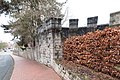
No remains of the oldest verifiable wall ring around the former monastery district and the former domain courtyard have survived. The market settlement, initially protected by the Stiftsburg, was fortified by a second wall ring. No parts of it have survived. In the first half of the 14th century, the third wall ring was created to include the new districts of Neustadt, Hagen and the settlement around Moritzstraße in the city fortifications. However, it excluded the suburbs and is largely preserved.
- on the north side along the Gande ( location ): 130 m long about 4 m high wall section made of rubble stones
- in the south along the street An der Stadtmauer with a breakthrough on the street Barfüßerkloster ( location ): 170 m long, about 2-3 m high wall section
- on the northern property border of Hennebergstrasse 6 and 8 ( location ): 20 m wall in the northern rear walls of the outbuildings.

Wall remains on the Gande

Wall breakthrough at An der Stadtmauer, Barfüßerkloster 9
Remains of the city fortifications and the gatehouse of the Marientor, west of Bismarckstrasse 1


Former abbey district and market square development
The abbey district emerged from the medieval abbey castle. In addition to the collegiate church and the abbey, a large number of residential and farm buildings belonged to the monastery complex. The area includes the streets Frohnhof, Burgstraße, Am Plan, Hagen, An der Tummelburg and Stifts Freiheit.
Former collegiate church
| location | designation | description |
ID |
image |
|---|---|---|---|---|
| Pin clearance 51 ° 52 ′ 13 ″ N, 10 ° 1 ′ 34 ″ O |
Former collegiate church of St. Anastasius and Innocentius | Protected according to § 3 (3) NDSchG |
 More pictures |
Former abbey
| location | designation | description |
ID |
image |
|---|---|---|---|---|
| Pin clearance 3 51 ° 52 ′ 14 ″ N, 10 ° 1 ′ 36 ″ O |
Former abbey, main building | Two-storey solid construction, erected from 1726. Protected according to § 3 (3) NDSchG |
 More pictures |
|
| Pin clearance 4 51 ° 52 ′ 13 ″ N, 10 ° 1 ′ 37 ″ O |
Former abbey, wing construction | Two-storey L-shaped solid construction, representative display gable for freedom from monastery, protected according to § 3 (3) NDSchG |
 More pictures |
|
| Pin clearance 4 51 ° 52 ′ 12 ″ N, 10 ° 1 ′ 37 ″ O |
Former abbey, Elisabethbrunnen | Sandstone fountain depicting Elisabeth Ernestine Antonie as the benefactress of the poor, created by Johan Caspar Käse in 1748. Protected according to § 3 (3) NDSchG |
 More pictures |
|
| Pin clearance 4 51 ° 52 ′ 13 ″ N, 10 ° 1 ′ 38 ″ O |
Former abbey, stair tower | Polygonal stair tower with arched portal, around 1600 Protected according to § 3 (3) NDSchG |
 More pictures |
|
| Pin clearance 4 51 ° 52 ′ 13 ″ N, 10 ° 1 ′ 38 ″ O |
Former abbey, chapel building | Two-storey quarry stone building with half-timbered upper storey, in the basement there is the Romanesque abbey chapel dedicated to the Archangel Michael Protected according to § 3 (3) NDSchG |
 More pictures |
|
| Pin clearance 4 51 ° 52 ′ 13 ″ N, 10 ° 1 ′ 39 ″ O |
Former abbey, gate construction | Three-storey quarry stone building with a large arched entrance to the abbey courtyard, with a staircase extension on the courtyard side. Protected according to § 3 (3) NDSchG |
 More pictures |
|
| Abbey Courtyard 4 51 ° 52 ′ 13 ″ N, 10 ° 1 ′ 39 ″ E |
Former abbey, wing construction | Three-storey built-in house with half-timbered upper storey, built in the local style after the domain was demolished in 1934. Protected according to § 3 (3) NDSchG |
 More pictures |
Development on the south side of the Stifts Freiheit
| location | designation | description |
ID |
image |
|---|---|---|---|---|
| Pin clearance 51 ° 52 ′ 12 ″ N, 10 ° 1 ′ 38 ″ O |
War memorial | Memorial to those who fell in both world wars Protected according to § 3 (2) NDSchG |
 More pictures |
|
| Pin clearance 5 51 ° 52 ′ 11 ″ N, 10 ° 1 ′ 38 ″ O |
Former girls' school, now police | Two-storey plastered building, 1844/46 Protected according to § 3 (3) NDSchG |
 More pictures |
|
| Pin clearance 6/7 51 ° 52 ′ 11 ″ N, 10 ° 1 ′ 36 ″ O |
So-called doctor's court | Two-storey half-timbered building on a high quarry stone base with two double flight of stairs, according to the inscription on the weather vane, built in 1711 by court judge and canon (1694–1712) Christian Philipp Probst, 1883 divided into two parts. Protected according to § 3 (3) NDSchG |
 More pictures |
|
| Pin clearance 8 51 ° 52 ′ 11 ″ N, 10 ° 1 ′ 35 ″ O |
Residential building | Two-storey plastered building from 1833 on the former plot of the former curia of the Knights of Gandersheim Protected according to § 3 (3) NDSchG |
 More pictures |
|
| Pin clearance 9 51 ° 52 ′ 11 ″ N, 10 ° 1 ′ 34 ″ O |
Residential building | Three-storey, classicist, plastered half-timbered building from 1833 on the former plot of the former curia of the Knights of Gandersheim, for a long time the company headquarters of the printer Carl Friedrich Hertel (1833–1871) Protected according to § 3 (3) NDSchG |
 More pictures |
|
| Stifts Freiheit 10, Barefoot Monastery 51 ° 52 ′ 11 ″ N, 10 ° 1 ′ 33 ″ E |
Residential building | Double-decker disguised half-timbered building on the corner of the street Franciscan mendicant, 1840 at the site where in the Middle Ages the House of Kaland Brotherhood was erected managed in accordance with § 3 (3) NDSchG |
 More pictures |
|
| Stifts Freiheit 11, Barefoot Monastery 51 ° 52 ′ 11 ″ N, 10 ° 1 ′ 33 ″ E |
Residential building | Two-storey plastered half-timbered building from 1883 Protected according to § 3 (3) NDSchG |
 More pictures |
|
| Pin clearance 13 51 ° 52 ′ 12 ″ N, 10 ° 1 ′ 31 ″ O |
Residential building | Two-storey brick building, erected in 1875 for master brewer Christoph Schulze Protected according to § 3 (3) NDSchG |
 More pictures |
|
| Pin clearance 14 51 ° 52 ′ 12 ″ N, 10 ° 1 ′ 30 ″ O |
Residential building | Two-story half-timbered building from 1755, trimmed down each floor. Protected according to § 3 (3) NDSchG |
 More pictures |
|
| Pin clearance 15 51 ° 52 ′ 12 ″ N, 10 ° 1 ′ 30 ″ O |
Residential building | Two-story half-timbered building with half-hipped roofing, summarizing two parts of the house, heavily modified Protected according to § 3 (3) NDSchG |
 More pictures |
Group: Historic town center Bad Gandersheim
The group "Historischer Ortskern Bad Gandersheim" has the ID 33538700.
| location | designation | description |
ID |
image |
|---|---|---|---|---|
| Market 51 ° 52 ′ 14 ″ N, 10 ° 1 ′ 29 ″ E |
Square area | 33812864 | ||
| Markt 1 51 ° 52 ′ 14 ″ N, 10 ° 1 ′ 28 ″ E |
Former Hotel Weißes Ross | Two half-timbered buildings merged at the end of the 18th century. The southern and northern parts are each three-story gable roof buildings. The northern part also has a dwelling. Protected according to § 3 (3) NDSchG |
33812887 |
 More pictures |
| Market 2 51 ° 52 ′ 14 ″ N, 10 ° 1 ′ 28 ″ E |
Residential and commercial building | Three-storey half-timbered building, built in 1581 according to the sill beam inscription, rebuilt in the second half of the 18th century. Protected according to § 3 (3) NDSchG |
33812910 |
 More pictures |
| Market 3 51 ° 52 ′ 14 ″ N, 10 ° 1 ′ 28 ″ E |
Residential and commercial building | Three-story half-timbered building on the corner of Steinweg, building inscription dated 1581 Protected according to § 3 (3) NDSchG |
33812932 |
 More pictures |
| Market 4 51 ° 52 ′ 15 ″ N, 10 ° 1 ′ 28 ″ E |
Residential building | Three-storey building from the early 19th century, trimmed down by storey, Protected according to § 3 (3) NDSchG |
33812955 |
 More pictures |
| Markt 5 51 ° 52 ′ 15 ″ N, 10 ° 1 ′ 29 ″ E |
Residential building | Three-storey building from the early 19th century, trimmed down by storey, Protected according to § 3 (3) NDSchG |
33812978 |
 More pictures |
| Markt 6 51 ° 52 ′ 15 ″ N, 10 ° 1 ′ 30 ″ E |
Residential building | Protected according to § 3 (3) NDSchG | 33813001 | |
| Markt 8 51 ° 52 ′ 14 ″ N, 10 ° 1 ′ 30 ″ E |
Residential house, so-called bracken | Two-storey quarry stone building with half-timbered upper floor, erected in 1473 for the bailiff Johannes Steinmann by master builder Hermann Müller Protected according to § 3 (3) NDSchG |
33813023 |
 More pictures |
| Market 9 51 ° 52 ′ 14 ″ N, 10 ° 1 ′ 31 ″ E |
Residential building | Three-storey half-timbered building with rich decorations, built in 1552 for merchant and councilor Harmen Blanken according to the building inscription. In the area of the upper floor protrusion one finds numerous dew beams, profiled lugs and ship throats. The uprights and angle pieces of wood on the upper floors are decorated with various fan rosettes. A so-called curtain arch is inserted between the ground floor and the mezzanine. Protected according to § 3 (3) NDSchG |
33813046 |
 More pictures |
| Marktplatz 10 51 ° 52 ′ 13 ″ N, 10 ° 1 ′ 29 ″ E |
town hall | Two-part building located at the intersection between the monastery district and the market settlement. The eastern part comes from the former market church, whose tower divides the building. The market church was first mentioned in 1378 and later sold by the abbey to the city. The western part is the actual town hall outside of the monastery district, which was first mentioned in 1432. On November 22nd, 1580 the market church and the town hall burned down to the ground. After the introduction of the Reformation, the market church was no longer used as a church, so it was rebuilt as a new town hall. Protected according to § 3 (3) NDSchG |
33813068 |
 More pictures |
Steinweg
The Steinweg runs almost in a straight line to the west from the market square to the former Georgstor. This section was mentioned as the Großer Steinweg as early as 1364. Then the road turns to the northwest and, after crossing the Grande, leads to the church of St. Georg. This section was formerly known as the Kleiner Steinweg. Eastern section of the stone path:
| location | designation | description |
ID |
image |
|---|---|---|---|---|
| Steinweg 1 51 ° 52 ′ 14 ″ N, 10 ° 1 ′ 27 ″ E |
Residential building | Three-story studded storey building, presumably built shortly after 1580, ground floor modern changed Protected according to § 3 (3) NDSchG |
 More pictures |
|
| Steinweg 2 51 ° 52 ′ 14 ″ N, 10 ° 1 ′ 26 ″ E |
Residential building | Protected according to § 3 (3) NDSchG |
 More pictures |
|
| Steinweg 3 51 ° 52 ′ 14 ″ N, 10 ° 1 ′ 26 ″ E |
Residential building | Three-storey stud-storey building, probably built around 1603. Protected according to § 3 (3) NDSchG |
 More pictures |
|
| Steinweg 5 51 ° 52 ′ 14 ″ N, 10 ° 1 ′ 25 ″ E |
Residential building | Three-storey stud-storey building, built around 1580 Protected according to § 3 (2) NDSchG |
 More pictures |
|
| Steinweg 40 51 ° 52 ′ 15 ″ N, 10 ° 1 ′ 24 ″ E |
Residential building | Two-storey eaves-standing post-storey building, dated to the second half of the 16th century due to the decorative shape of the framework. Protected according to § 3 (3) NDSchG |
 More pictures |
|
| Steinweg 41 51 ° 52 ′ 15 ″ N, 10 ° 1 ′ 25 ″ E |
Residential building | Two-storey timber-framed building, erected in 1661 for the mayor and councilor Heinrich Krumauge. Protected according to § 3 (3) NDSchG |
 More pictures |
|
| Steinweg 42 51 ° 52 ′ 15 ″ N, 10 ° 1 ′ 25 ″ E |
Residential building | Two-storey timber-framed building, erected in 1661 Protected according to § 3 (3) NDSchG |
 More pictures |
|
| Steinweg 43 51 ° 52 ′ 15 ″ N, 10 ° 1 ′ 26 ″ E |
Residential building | Half-timbered building with modified ground floor Protected according to § 3 (3) NDSchG |
 More pictures |
|
| Steinweg 44 51 ° 52 ′ 15 ″ N, 10 ° 1 ′ 26 ″ E |
Residential building | Half-timbered building with modified ground floor Protected according to § 3 (3) NDSchG |
 More pictures |
|
| Steinweg 45 51 ° 52 ′ 15 ″ N, 10 ° 1 ′ 27 ″ E |
Residential building | Half-timbered building with modified ground floor Protected according to § 3 (3) NDSchG |
 More pictures |
|
| Steinweg 46 51 ° 52 ′ 15 ″ N, 10 ° 1 ′ 27 ″ E |
Residential building | Half-timbered building with modified ground floor Protected according to § 3 (3) NDSchG |
 More pictures |
|
| Steinweg 47 51 ° 52 ′ 15 ″ N, 10 ° 1 ′ 27 ″ E |
Residential building | Half-timbered building with modified ground floor Protected according to § 3 (3) NDSchG |
 More pictures |
|
| Steinweg 48 51 ° 52 ′ 15 ″ N, 10 ° 1 ′ 28 ″ E |
Residential building | Half-timbered building with modified ground floor Protected according to § 3 (3) NDSchG |
 More pictures |
Western section of the stone path:
| location | designation | description |
ID |
image |
|---|---|---|---|---|
| Steinweg 10 51 ° 52 ′ 14 ″ N, 10 ° 1 ′ 22 ″ E |
Residential building | Protected according to § 3 (3) NDSchG |
 More pictures |
|
| Steinweg 11 51 ° 52 ′ 14 ″ N, 10 ° 1 ′ 22 ″ E |
Residential building | Protected according to § 3 (3) NDSchG |
 More pictures |
|
| Steinweg 12 51 ° 52 ′ 14 ″ N, 10 ° 1 ′ 22 ″ E |
Residential building | Protected according to § 3 (3) NDSchG |
 More pictures |
|
| Steinweg 13 51 ° 52 ′ 14 ″ N, 10 ° 1 ′ 21 ″ E |
Residential building | Protected according to § 3 (3) NDSchG |
 More pictures |
|
| Steinweg 14 51 ° 52 ′ 14 ″ N, 10 ° 1 ′ 21 ″ E |
Residential building | Protected according to § 3 (3) NDSchG |
 More pictures |
|
| Steinweg 15 51 ° 52 ′ 14 ″ N, 10 ° 1 ′ 21 ″ E |
Residential building | Protected according to § 3 (3) NDSchG |
 More pictures |
|
| Steinweg 16 51 ° 52 ′ 14 ″ N, 10 ° 1 ′ 20 ″ E |
Residential building | Protected according to § 3 (3) NDSchG |
 More pictures |
|
| Steinweg 17 51 ° 52 ′ 14 ″ N, 10 ° 1 ′ 20 ″ E |
Residential building | Protected according to § 3 (3) NDSchG |
 More pictures |
|
| Steinweg 18 51 ° 52 ′ 14 ″ N, 10 ° 1 ′ 19 ″ E |
Residential building | Two-storey half-timbered building with mansard roof and classicist front door Protected according to § 3 (3) NDSchG |
 More pictures |
|
| Steinweg 19 51 ° 52 ′ 14 ″ N, 10 ° 1 ′ 18 ″ E |
Former hospital of the Holy Spirit | The Hospital of the Holy Spirit, founded in 1238, was once located on the Steinweg 19 to 20a and Pump area. The gabled half-timbered building Steinweg 19 from 1763 is the only one that has survived. Protected according to § 3 (3) NDSchG |
 More pictures |
|
| Steinweg 20 51 ° 52 ′ 14 ″ N, 10 ° 1 ′ 18 ″ E |
Residential building | Protected according to § 3 (3) NDSchG |
 More pictures |
|
| Pump 2 51 ° 52 ′ 15 ″ N, 10 ° 1 ′ 17 ″ E |
Residential building | Protected according to § 3 (3) NDSchG |
 More pictures |
|
| Pump 3 51 ° 52 '15 "N, 10 ° 1' 17" O |
Residential building | Protected according to § 3 (3) NDSchG |
More pictures |
|
| Steinweg 23 51 ° 52 ′ 16 ″ N, 10 ° 1 ′ 16 ″ E |
Residential building | Protected according to § 3 (2) NDSchG |
 More pictures |
|
| Steinweg 24 51 ° 52 ′ 16 ″ N, 10 ° 1 ′ 16 ″ E |
Successor to the former Georgsmühle | Protected according to § 3 (3) NDSchG |
 More pictures |
|
| Steinweg 24 51 ° 52 ′ 17 ″ N, 10 ° 1 ′ 14 ″ E |
Weir of the former Georgsmühle | Protected according to § 3 (2) NDSchG |
 More pictures |
|
| Steinweg 24a 51 ° 52 ′ 16 ″ N, 10 ° 1 ′ 16 ″ E |
Successor to the former Georgsmühle | Protected according to § 3 (3) NDSchG |
 More pictures |
|
| Steinweg 25 51 ° 52 ′ 16 ″ N, 10 ° 1 ′ 17 ″ E |
Residential building | Protected according to § 3 (2) NDSchG |
 More pictures |
|
| Steinweg 29 51 ° 52 ′ 15 ″ N, 10 ° 1 ′ 19 ″ E |
Residential building | Protected according to § 3 (3) NDSchG |
 More pictures |
|
| Steinweg 30 51 ° 52 ′ 15 ″ N, 10 ° 1 ′ 19 ″ E |
Residential building | Protected according to § 3 (3) NDSchG |
 More pictures |
On the historical western outskirts of the city is the Sankt Georgskirche with cemetery.
| location | designation | description |
ID |
image |
|---|---|---|---|---|
| Sankt-Georg-Strasse 51 ° 52 ′ 17 ″ N, 10 ° 1 ′ 13 ″ E |
St. George Church | The core of the church with the west tower dates back to the 12th century. It was the actual parish church in the Middle Ages and was outside the city walls. Protected according to § 3 (2) NDSchG |
 More pictures |
|
| Sankt-Georg-Strasse 51 ° 52 ′ 18 ″ N, 10 ° 1 ′ 10 ″ E |
graveyard | Protected according to § 3 (2) NDSchG |
 More pictures |
|
| Sankt-Georg-Strasse 51 ° 52 ′ 17 ″ N, 10 ° 1 ′ 11 ″ E |
War memorial | For those killed in the First World War Protected according to § 3 (2) NDSchG |
 More pictures |
The Jewish cemetery is to the north of St. George's Church.
| location | designation | description |
ID |
image |
|---|---|---|---|---|
| At the Wiek 51 ° 52 ′ 22 ″ N, 10 ° 1 ′ 13 ″ E |
Jewish Cemetery | About 40 tombs, the oldest from the end of the 18th century. Protected according to § 3 (2) NDSchG |
Moritzstrasse
Moritzstraße extends south from the market square to the abandoned Galgentor. The street name appears for the first time in 1669 and refers to the Moritzkirche, the former market church.
| location | designation | description |
ID |
image |
|---|---|---|---|---|
| Moritzstrasse 15 51 ° 52 ′ 11 ″ N, 10 ° 1 ′ 27 ″ E |
Residential and commercial building | Five-axis half-timbered building on the eaves, building inscription dated to 1678 Protected according to § 3 (2) NDSchG |
 More pictures |
|
| Moritzstrasse 18 51 ° 52 ′ 12 ″ N, 10 ° 1 ′ 27 ″ E |
Residential and commercial building | Plastered half-timbered building, around 1600 Protected according to § 3 (3) NDSchG |
 More pictures |
|
| Moritzstrasse 19/20 51 ° 52 ′ 12 ″ N, 10 ° 1 ′ 27 ″ E |
Residential and commercial building | An eaves half-timbered building from the second half of the 18th century that was built from three separate houses. Ground floor completely gutted. Protected according to § 3 (3) NDSchG |
 More pictures |
|
| Moritzstrasse 22 51 ° 52 ′ 13 ″ N, 10 ° 1 ′ 28 ″ E |
Residential and commercial building | Half-timbered building from the second half of the 18th century Protected according to § 3 (2) NDSchG |
 More pictures |
|
| Moritzstrasse 30 51 ° 52 ′ 11 ″ N, 10 ° 1 ′ 29 ″ E |
Residential building | Half-timbered building, probably 2nd half of the 16th century Protected according to § 3 (2) NDSchG |
More pictures |
|
| Moritzstrasse 39 51 ° 52 ′ 8 ″ N, 10 ° 1 ′ 29 ″ E |
Residential and commercial building | Two-storey plastered building from 1905/05 Protected according to § 3 (2) NDSchG |
 More pictures |
Bismarckstrasse
The road leads eastwards from the Stifts Freiheit. On the occasion of Bismarck's 80th birthday in 1895, the street formerly known as the New Village was given its current name.
| location | designation | description |
ID |
image |
|---|---|---|---|---|
| Bismarckstrasse 1 51 ° 52 ′ 11 ″ N, 10 ° 1 ′ 41 ″ E |
Hotel Prince Wilhelm | Erected on the city moat area after the outer Marientor was torn down. The innkeeper Ludwig Koch acquired the property from the city on March 11, 1830. Protected according to § 3 (3) NDSchG |
||
| Bismarckstrasse 2 51 ° 52 ′ 11 ″ N, 10 ° 1 ′ 42 ″ E |
Residential building | Half-timbered house, around 1700 Protected according to § 3 (3) NDSchG |
||
| Bismarckstrasse 3 51 ° 52 ′ 10 ″ N, 10 ° 1 ′ 42 ″ E |
Residential building | Protected according to § 3 (3) NDSchG |
 More pictures |
|
| Bismarckstrasse 6 51 ° 52 ′ 9 ″ N, 10 ° 1 ′ 45 ″ E |
Residential building | Protected according to § 3 (3) NDSchG |
 More pictures |
|
| Bismarckstrasse 7 51 ° 52 ′ 9 ″ N, 10 ° 1 ′ 45 ″ E |
Residential building | Protected according to § 3 (3) NDSchG |
 More pictures |
|
| Bismarckstrasse 8 51 ° 52 ′ 9 ″ N, 10 ° 1 ′ 47 ″ E |
Old coin | Stately half-timbered building, 1690 Protected according to § 3 (2) NDSchG |
 More pictures |
|
| Bismarckstrasse 10 51 ° 52 ′ 7 ″ N, 10 ° 1 ′ 51 ″ E |
Residential building | Detached villa-like brick building with ashlar structures and polygonal bay windows, 1897 Protected according to § 3 (2) NDSchG |
||
| Bismarckstrasse 17 51 ° 52 ′ 6 ″ N, 10 ° 1 ′ 59 ″ E |
Former Realgymnasium, now Roswitha-Gymnasium | Stately three-part brick building, 1894 Protected according to § 3 (2) NDSchG |
||
| Bismarckstrasse 26 51 ° 52 ′ 7 ″ N, 10 ° 1 ′ 49 ″ E |
Former poor house | Two-storey half-timbered building, 1831/33 Protected according to § 3 (2) NDSchG |
 More pictures |
|
| Bismarckstrasse 27 51 ° 52 ′ 7 ″ N, 10 ° 1 ′ 48 ″ E |
Residential building | Two-storey half-timbered building, 1882 Protected according to § 3 (2) NDSchG |
 More pictures |
|
| Marienkloster 5 51 ° 52 ′ 9 ″ N, 10 ° 1 ′ 41 ″ E |
Residential building | Protected according to § 3 (3) NDSchG | ||
| Marienkloster 6 51 ° 52 ′ 9 ″ N, 10 ° 1 ′ 41 ″ E |
Residential building | Protected according to § 3 (3) NDSchG | ||
| Marienkloster 7 51 ° 52 ′ 9 ″ N, 10 ° 1 ′ 41 ″ E |
Residential building | Protected according to § 3 (3) NDSchG | ||
| Marienkloster 8 51 ° 52 ′ 9 ″ N, 10 ° 1 ′ 42 ″ E |
Residential building | Protected according to § 3 (3) NDSchG |
 More pictures |
|
| Marienkloster 10 51 ° 52 ′ 9 ″ N, 10 ° 1 ′ 43 ″ E |
Residential building | Protected according to § 3 (3) NDSchG |
 More pictures |
|
| Bismarckstrasse 34 51 ° 52 ′ 9 ″ N, 10 ° 1 ′ 43 ″ E |
Residential building | Protected according to § 3 (3) NDSchG |
 More pictures |
|
| Bismarckstrasse 35 51 ° 52 ′ 10 ″ N, 10 ° 1 ′ 43 ″ E |
Residential building | Half-timbered building, first half of the 18th century Protected according to § 3 (3) NDSchG |
 More pictures |
|
| Bismarckstrasse 36 51 ° 52 ′ 10 ″ N, 10 ° 1 ′ 42 ″ E |
Residential building | Half-timbered building, end of the 19th century Protected according to § 3 (3) NDSchG |
 More pictures |
|
| Bismarckstrasse 37 51 ° 52 ′ 10 ″ N, 10 ° 1 ′ 42 ″ E |
Residential building | Half-timbered building, end of the 19th century Protected according to § 3 (3) NDSchG |
 More pictures |
|
| Bismarckstrasse 38 51 ° 52 ′ 10 ″ N, 10 ° 1 ′ 42 ″ E |
Residential building | Half-timbered building, end of the 19th century Protected according to § 3 (3) NDSchG |
 More pictures |
|
| Bismarckstrasse 39 51 ° 52 ′ 10 ″ N, 10 ° 1 ′ 41 ″ E |
Residential building | Protected according to § 3 (3) NDSchG |
 More pictures |
|
| Bismarckstrasse 40 51 ° 52 ′ 10 ″ N, 10 ° 1 ′ 41 ″ E |
Residential building | Protected according to § 3 (3) NDSchG |
 More pictures |
|
| Bismarckstrasse 41 51 ° 52 ′ 10 ″ N, 10 ° 1 ′ 41 ″ E |
Residential building | Protected according to § 3 (3) NDSchG |
 More pictures |
|
| Bismarckstrasse 42 51 ° 52 ′ 11 ″ N, 10 ° 1 ′ 40 ″ E |
Residential building | Protected according to § 3 (3) NDSchG |
 More pictures |
Burgstrasse
Burgstrasse was part of the old long-distance trade route to Hildesheim. It runs northeast from the market square and is continued in the streets Am Plan, Neustadt and Hildesheimer Straße. In 1582 it is mentioned as Mühlstrasse. Burgstrasse was the name of the northern side of the plan, which was built with town houses until the building was demolished as part of the burger expansion and the creation of the square in 1530.
| location | designation | description |
ID |
image |
|---|---|---|---|---|
| Burgstrasse 2 51 ° 52 ′ 15 ″ N, 10 ° 1 ′ 30 ″ E |
Former restaurant Zum Adler | Elongated two-storey half-timbered building, 1893 Protected according to § 3 (2) NDSchG |
 More pictures |
|
| Burgstrasse 4 51 ° 52 ′ 16 ″ N, 10 ° 1 ′ 31 ″ E |
Residential building | Half-timbered building, in the core of the 18th century, protected according to § 3 (3) NDSchG |
 More pictures |
|
| Burgstrasse 5 51 ° 52 ′ 17 ″ N, 10 ° 1 ′ 31 ″ E |
Residential building | Half-timbered building, around 1800 Protected according to § 3 (3) NDSchG |
 More pictures |
|
| Burgstrasse 6 51 ° 52 ′ 17 ″ N, 10 ° 1 ′ 32 ″ E |
Residential building | Half-timbered building, around 1800 Protected according to § 3 (3) NDSchG |
 More pictures |
|
| Hennebergstrasse 2 51 ° 52 ′ 17 ″ N, 10 ° 1 ′ 31 ″ E |
Residential building | Half-timbered building, end of the 18th century Protected according to § 3 (3) NDSchG |
 More pictures |
|
| Hennebergstrasse 3 51 ° 52 ′ 18 ″ N, 10 ° 1 ′ 31 ″ E |
Residential building | Half-timbered building, around 1700 Protected according to § 3 (3) NDSchG |
 More pictures |
|
| Hennebergstrasse 8 51 ° 52 ′ 19 ″ N, 10 ° 1 ′ 31 ″ E |
Residential building | Half-timbered building, second half of the 18th century Protected according to § 3 (2) NDSchG |
 More pictures |
|
| Burgstrasse 7 51 ° 52 ′ 16 ″ N, 10 ° 1 ′ 33 ″ E |
Residential and commercial building | Protected according to § 3 (3) NDSchG |
 More pictures |
|
| Burgstrasse 8 51 ° 52 ′ 16 ″ N, 10 ° 1 ′ 33 ″ E |
Residential and commercial building | Protected according to § 3 (3) NDSchG |
 More pictures |
|
| Burgstrasse 9 51 ° 52 ′ 16 ″ N, 10 ° 1 ′ 34 ″ E |
Residential and commercial building | Protected according to § 3 (3) NDSchG |
 More pictures |
|
| Burgstrasse 10 51 ° 52 ′ 16 ″ N, 10 ° 1 ′ 34 ″ E |
Residential and commercial building | Protected according to § 3 (3) NDSchG |
 More pictures |
|
| Fronhof 1 51 ° 52 ′ 15 ″ N, 10 ° 1 ′ 34 ″ E |
Residential and commercial building | Protected according to § 3 (2) NDSchG |
 More pictures |
On the plan
The square was created in the first half of the 16th century when the castle was expanded south of the castle to improve the defensive possibilities. For this purpose, the buildings at that time were demolished.
| location | designation | description |
ID |
image |
|---|---|---|---|---|
| Am Plan 1, Burgstrasse 51 ° 52 ′ 16 ″ N, 10 ° 1 ′ 36 ″ E |
Hotel Roman Emperor | Two-storey half-timbered building, around 1660 Protected according to § 3 (3) NDSchG |
 More pictures |
|
| On plan 3b 51 ° 52 ′ 19 ″ N, 10 ° 1 ′ 41 ″ E |
Castle complex, today's district court | An official court emerged from the ducal castle. The district court has been using the facility since the middle of the 19th century. Protected according to § 3 (3) NDSchG |
 More pictures |
|
| On plan 3a 51 ° 52 ′ 19 ″ N, 10 ° 1 ′ 35 ″ E |
Castle complex, today's building yard | Former official barn Protected according to § 3 (2) NDSchG |
 More pictures |
|
| On Plan 3 51 ° 52 ′ 18 ″ N, 10 ° 1 ′ 36 ″ E |
Castle complex, gate house | Single-storey half-timbered building with a dwelling protected according to § 3 (3) NDSchG |
 More pictures |
|
| Am Plan 3, Am Stadtwall 51 ° 52 ′ 18 ″ N, 10 ° 1 ′ 35 ″ E |
Castle complex, farmyard | Two-storey half-timbered buildings Protected according to § 3 (3) NDSchG |
 More pictures |
|
| On Plan 4 51 ° 52 ′ 16 ″ N, 10 ° 1 ′ 41 ″ E |
Residential building | Two-storey half-timbered building, mid-19th century Protected according to § 3 (3) NDSchG |
 More pictures |
|
| On plan 5 51 ° 52 ′ 16 ″ N, 10 ° 1 ′ 41 ″ E |
Residential and commercial building | Three-storey curtained half-timbered building, probably built around 1760. Protected according to § 3 (3) NDSchG |
 More pictures |
|
| On Plan 9 51 ° 52 ′ 15 ″ N, 10 ° 1 ′ 37 ″ E |
Catholic Church of the Assumption of Mary | Block-like, rectangular plastered building with retracted choir, 1952/53 Protected according to § 3 (3) NDSchG |
 More pictures |
Neustadt
The street is first mentioned as Neustadt in 1569. Previously it was called a suburb. The Hagentor was built at the transition from the old town to the new town. An outer gate was added to the city fortifications, as the location name "Between the Hagentoren" attested in 1466 expresses.
| location | designation | description |
ID |
image |
|---|---|---|---|---|
| Neustadt 2 51 ° 52 ′ 18 ″ N, 10 ° 1 ′ 43 ″ E |
Residential building | Two-story half-timbered building, around 1660 Protected according to § 3 (3) NDSchG |
 More pictures |
|
| Neustadt 3/4 51 ° 52 ′ 18 ″ N, 10 ° 1 ′ 43 ″ E |
Residential building | Plaster and brick construction, 1900 Protected according to § 3 (3) NDSchG |
 More pictures |
|
| Neustadt 5 51 ° 52 ′ 19 ″ N, 10 ° 1 ′ 44 ″ E |
Residential building | Protected according to § 3 (3) NDSchG |
 More pictures |
|
| Neustadt 6 51 ° 52 ′ 19 ″ N, 10 ° 1 ′ 44 ″ E |
Residential building | Protected according to § 3 (3) NDSchG |
 More pictures |
|
| Neustadt 7 51 ° 52 ′ 19 ″ N, 10 ° 1 ′ 44 ″ E |
Residential building | Half-timbered building on storeys, probably at the end of the 17th century Protected according to § 3 (3) NDSchG |
 More pictures |
|
| Neustadt 8 51 ° 52 ′ 19 ″ N, 10 ° 1 ′ 45 ″ E |
Residential building | Half-timbered building, trimmed in storeys, protected in accordance with § 3 (3) NDSchG |
 More pictures |
|
| Neustadt 9 51 ° 52 ′ 19 ″ N, 10 ° 1 ′ 45 ″ E |
Residential building | Two-storey timber-framed half-timbered building, 1883 Protected according to § 3 (3) NDSchG |
 More pictures |
|
| Neustadt 13 51 ° 52 ′ 18 ″ N, 10 ° 1 ′ 44 ″ E |
Residential building | Two-storey half-timbered building Protected according to § 3 (3) NDSchG |
 More pictures |
|
| Neustadt 14 51 ° 52 ′ 18 ″ N, 10 ° 1 ′ 44 ″ E |
Residential building | Protected according to § 3 (3) NDSchG |
 More pictures |
Hildesheimer Strasse
Hildesheimer Straße is the continuation of Neustadt street in a north-east direction. The buildings from the end of the 19th century to the beginning of the 20th century bear witness to the emerging spa business at the turn of the century.
| location | designation | description |
ID |
image |
|---|---|---|---|---|
| Hildesheimer Strasse 51 ° 52 ′ 29 ″ N, 10 ° 2 ′ 3 ″ E |
Railway bridge | Arch bridge made of natural stone blocks for the Bad Gandersheim-Hildesheim railway line opened in 1901. Protected according to § 3 (2) NDSchG |
||
| Hildesheimer Strasse 2 51 ° 52 ′ 24 ″ N, 10 ° 1 ′ 49 ″ E |
Residential building | Two-storey plastered building, erected in 1913 for master mason Friedrich Wilhelm Leopold Prahmann. Protected according to § 3 (2) NDSchG |
||
| Hildesheimer Strasse 3 51 ° 52 ′ 26 ″ N, 10 ° 1 ′ 50 ″ E |
Residential building | Stately brick building, built in 1889 for master mason Friedrich Prahmann. Protected according to § 3 (2) NDSchG |
||
| Hildesheimer Strasse 4 51 ° 52 ′ 26 ″ N, 10 ° 1 ′ 51 ″ E |
Residential building | One and a half storey villa-like brick building, for the manufacturer August Schütte Protected according to § 3 (2) NDSchG |
||
| Hildesheimer Strasse 5 51 ° 52 ′ 27 ″ N, 10 ° 1 ′ 52 ″ E |
Ballin house | Representative villa, 1889 for businessman Louis Ballin, the head of the Jewish community, city councilor and member of the magistrate Protected according to § 3 (2) NDSchG |
||
| Hildesheimer Strasse 7 51 ° 52 ′ 31 ″ N, 10 ° 2 ′ 5 ″ E |
Former Badehotel Schüßler | Three-storey plastered building, built in 1879 for master mason August Schüßler as a bathing hotel Protected according to § 3 (2) NDSchG |
||
| At Osterbergsee 51 ° 52 ′ 25 ″ N, 10 ° 2 ′ 4 ″ E |
Railway bridge | Bridge made of natural stone blocks for the Bad Gandersheim-Hildesheim railway line opened in 1901. Protected according to § 3 (2) NDSchG |
Barefoot monastery
The street name is reminiscent of the Franciscan monastery that was founded here in 1501. After the fire of 1834, two- and three-story, partially clad, half-timbered buildings were built on the east side of the street.
| location | designation | description |
ID |
image |
|---|---|---|---|---|
| Barefoot Monastery 2 51 ° 52 ′ 10 ″ N, 10 ° 1 ′ 32 ″ E |
Residential building | Three-axis half-timbered building on a high basement, protected according to § 3 (3) NDSchG |
 More pictures |
|
| Barefoot Monastery 2 51 ° 52 ′ 10 ″ N, 10 ° 1 ′ 32 ″ E |
Tombstone | Late Gothic, red sandstone, for Henning Lindemann, who died in 1514, attached to the base of the house. Protected according to § 3 (3) NDSchG |
||
| Barefoot monastery 3 51 ° 52 ′ 9 ″ N, 10 ° 1 ′ 32 ″ E |
Residential building | Protected according to § 3 (3) NDSchG |
 More pictures |
|
| Barefoot Monastery 4 51 ° 52 ′ 9 ″ N, 10 ° 1 ′ 32 ″ E |
Residential building | Protected according to § 3 (3) NDSchG |
More pictures |
|
| Barefoot Monastery 5 51 ° 52 ′ 9 ″ N, 10 ° 1 ′ 32 ″ E |
Residential building | Protected according to § 3 (3) NDSchG |
 More pictures |
|
| Barefoot monastery 6 51 ° 52 ′ 9 ″ N, 10 ° 1 ′ 32 ″ E |
Residential building | Protected according to § 3 (3) NDSchG |
 More pictures |
|
| Barefoot monastery 7 51 ° 52 ′ 9 ″ N, 10 ° 1 ′ 32 ″ E |
Residential building | Protected according to § 3 (3) NDSchG |
 More pictures |
|
| Barefoot monastery 10 51 ° 52 ′ 9 ″ N, 10 ° 1 ′ 32 ″ E |
Residential building | Two-storey half-timbered building from 1836 Protected according to § 3 (3) NDSchG |
||
| Barefoot Monastery 11/12 51 ° 52 ′ 9 ″ N, 10 ° 1 ′ 31 ″ E |
Residential building | Two-story half-timbered building from 1835/36 Protected according to § 3 (3) NDSchG |
 More pictures |
|
| Barefoot Monastery 15 51 ° 52 ′ 11 ″ N, 10 ° 1 ′ 31 ″ E |
So-called Wilhelmsburg | Elongated plastered building, erected in 1896 for leather manufacturer August Zaps on the site of the abandoned Wilhelmsburg. Protected according to § 3 (3) NDSchG |
 More pictures |
Hagen
The street Hagen is first mentioned in a document in 1399. Due to structural interventions, the existing buildings from Hagen 4 to 10 do not appear very homogeneous. In some cases the building stock goes back to the 16th century.
| location | designation | description |
ID |
image |
|---|---|---|---|---|
| Hagen 4 51 ° 52 ′ 15 ″ N, 10 ° 1 ′ 40 ″ E |
Residential building | Protected according to § 3 (2) NDSchG |
 More pictures |
|
| Hagen 5 51 ° 52 ′ 16 ″ N, 10 ° 1 ′ 41 ″ E |
Residential building | Eaves standing studded storey construction, probably 16th century. The high stands combine the ground floor and mezzanine. The cantilevered upper floor rests on it in beam thickness. Protected according to § 3 (3) NDSchG |
 More pictures |
|
| Hagen 6 51 ° 52 ′ 15 ″ N, 10 ° 1 ′ 41 ″ E |
Residential building | Ständgschoss building on the eaves, probably 16th century. The high stands combine the ground floor and mezzanine. The cantilevered upper floor rests on it in beam thickness. Protected according to § 3 (3) NDSchG |
 More pictures |
|
| Hagen 7 51 ° 52 ′ 15 ″ N, 10 ° 1 ′ 41 ″ E |
Residential building | Two-story timber-framed building, end of the 18th century, protected according to § 3 (3) NDSchG |
 More pictures |
|
| Hagen 8 51 ° 52 ′ 15 ″ N, 10 ° 1 ′ 42 ″ E |
Residential building | Two-storey half-timbered building, probably second half of the 18th century. Protected according to § 3 (3) NDSchG |
 More pictures |
|
| Hagen 9 51 ° 52 ′ 15 ″ N, 10 ° 1 ′ 42 ″ E |
Residential building | Protected according to § 3 (3) NDSchG |
 More pictures |
|
| Hagen 10 51 ° 52 '14 "N, 10 ° 1' 42" E |
Residential building | Half-timbered building, built in 1834 by the master carpenter Johann Heinrich Schuhmann, ground floor disturbed by later shop installation Protected according to § 3 (3) NDSchG |
 More pictures |
Old alley
The road was first mentioned in 1437 as Hole Gatze. In the first half of the 16th century, 22 houses lined the street. They were rebuilt after the city fire of 1580. After the Thirty Years War in 1648, only seven houses are still inhabited. In 1650 the street is mentioned as a deserted estate in the castle register. The current building stock at Alte Gasse 1 to 18 consists of two- to three-storey, timber-framed half-timbered buildings on both sides of the street. The majority of the buildings date from the first half of the 19th century. The buildings at Alte Gasse 12, 14, 15, 16 date from the middle of the 18th century.
| location | designation | description |
ID |
image |
|---|---|---|---|---|
| Alte Gasse 1 51 ° 52 ′ 11 ″ N, 10 ° 1 ′ 27 ″ E |
Residential building | Protected according to § 3 (3) NDSchG |
 More pictures |
|
| Alte Gasse 2 51 ° 52 ′ 12 ″ N, 10 ° 1 ′ 27 ″ E |
Residential building | Protected according to § 3 (3) NDSchG |
 More pictures |
|
| Alte Gasse 3 51 ° 52 ′ 11 ″ N, 10 ° 1 ′ 26 ″ E |
Residential building | Protected according to § 3 (3) NDSchG |
 More pictures |
|
| Alte Gasse 4 51 ° 52 ′ 12 ″ N, 10 ° 1 ′ 26 ″ E |
Residential building | Protected according to § 3 (3) NDSchG |
 More pictures |
|
| Alte Gasse 5 51 ° 52 ′ 11 ″ N, 10 ° 1 ′ 26 ″ E |
Residential building | Protected according to § 3 (3) NDSchG |
 More pictures |
|
| Alte Gasse 6 51 ° 52 ′ 12 ″ N, 10 ° 1 ′ 26 ″ E |
Residential building | Protected according to § 3 (3) NDSchG |
 More pictures |
|
| Alte Gasse 7 51 ° 52 ′ 11 ″ N, 10 ° 1 ′ 25 ″ E |
Residential building | Protected according to § 3 (3) NDSchG |
 More pictures |
|
| Alte Gasse 8 51 ° 52 ′ 12 ″ N, 10 ° 1 ′ 25 ″ E |
Residential building | Protected according to § 3 (3) NDSchG |
 More pictures |
|
| Alte Gasse 9 51 ° 52 ′ 11 ″ N, 10 ° 1 ′ 25 ″ E |
Residential building | Protected according to § 3 (3) NDSchG |
 More pictures |
|
| Alte Gasse 10 51 ° 52 ′ 12 ″ N, 10 ° 1 ′ 25 ″ E |
Residential building | Protected according to § 3 (3) NDSchG |
 More pictures |
|
| Alte Gasse 11 51 ° 52 ′ 11 ″ N, 10 ° 1 ′ 25 ″ E |
Residential building | Protected according to § 3 (3) NDSchG |
 More pictures |
|
| Alte Gasse 12 51 ° 52 ′ 12 ″ N, 10 ° 1 ′ 24 ″ E |
Residential building | Protected according to § 3 (3) NDSchG |
 More pictures |
|
| Alte Gasse 13 51 ° 52 ′ 11 ″ N, 10 ° 1 ′ 25 ″ E |
Residential building | Protected according to § 3 (3) NDSchG |
 More pictures |
|
| Alte Gasse 14 51 ° 52 ′ 12 ″ N, 10 ° 1 ′ 24 ″ E |
Residential building | Protected according to § 3 (3) NDSchG |
 More pictures |
|
| Alte Gasse 15 51 ° 52 ′ 11 ″ N, 10 ° 1 ′ 24 ″ E |
Residential building | Protected according to § 3 (3) NDSchG |
 More pictures |
|
| Alte Gasse 16 51 ° 52 ′ 12 ″ N, 10 ° 1 ′ 23 ″ E |
Residential building | Protected according to § 3 (3) NDSchG |
 More pictures |
|
| Alte Gasse 17 51 ° 52 ′ 11 ″ N, 10 ° 1 ′ 24 ″ E |
Residential building | Two-storey timber-framed building from the first half of the 18th century Protected according to § 3 (3) NDSchG |
 More pictures |
|
| Alte Gasse 18 51 ° 52 ′ 12 ″ N, 10 ° 1 ′ 23 ″ E |
Residential building | Protected according to § 3 (3) NDSchG |
 More pictures |
New street
Neue Straße is outside the old town and leads west from Moritzstraße. There are mostly free-standing, villa-like solid buildings with front gardens.
| location | designation | description |
ID |
image |
|---|---|---|---|---|
| Neue Straße 1 51 ° 52 ′ 6 ″ N, 10 ° 1 ′ 26 ″ E |
Former post office | Two-storey brick building in a corner, 1888 Protected according to § 3 (2) NDSchG |
||
| Neue Straße 2 51 ° 52 ′ 7 ″ N, 10 ° 1 ′ 25 ″ E |
Residential building | Two-storey brick building, 1898 Protected according to § 3 (2) NDSchG |
||
| Neue Strasse 3 51 ° 52 ′ 6 ″ N, 10 ° 1 ′ 25 ″ E |
Residential building | Timber-framed timber-frame construction, around 1870/80 Protected according to § 3 (2) NDSchG |
||
| Neue Straße 4 51 ° 52 ′ 7 ″ N, 10 ° 1 ′ 24 ″ E |
Residential building | Villa-like three-storey plastered building, 1901–02 for district physician Dr. Room erected Protected according to § 3 (2) NDSchG |
||
| Neue Straße 25 51 ° 52 ′ 6 ″ N, 10 ° 1 ′ 9 ″ E |
Villa Margarethe | Established in 1894 for the dairy owner Wilhelm Veth Protected according to § 3 (2) NDSchG |
||
| Bahnhofstrasse 1 51 ° 52 ′ 3 ″ N, 10 ° 1 ′ 12 ″ E |
Station entrance building | Two-storey stone building on the Börsum-Kreinsen-Holzminden railway line opened in 1856. Protected according to § 3 (2) NDSchG |
Outside the local area
| location | designation | description |
ID |
image |
|---|---|---|---|---|
| Clusberg 51 ° 52 ′ 50 ″ N, 10 ° 0 ′ 30 ″ E |
tower | The observation tower, the so-called Wilhelmsturm, is originally a five-story tower on a square base. The inauguration took place on August 30, 1900. Only the massive quarry stone floors, the ground floor and the first floor, have been preserved. The half-timbered upper floors were removed in 1975. | 33816085 | |
| Clusberg, near the Wilhelmsturm 51 ° 52 ′ 49 ″ N, 10 ° 0 ′ 31 ″ E |
monument | Sandstone obelisk, erected in 1874 for Hoffmann von Fallersleben from the Concordia Liedertafel | 33816108 |
Architectural monuments in the districts
Ackenhausen
| location | designation | description |
ID |
image |
|---|---|---|---|---|
| At the tub 9 51 ° 53 '28 "N, 10 ° 4' 6" E |
Courtyard | Three-sided courtyard with residential building from 1904 on the west side, goat barn in the south, half-timbered barn on the east side Protected according to § 3 (3) NDSchG |
||
| Bachstrasse 6 51 ° 53 ′ 26 ″ N, 10 ° 4 ′ 0 ″ E |
Former home of the community shepherd | Half-timbered building, mid-18th century Protected according to § 3 (2) NDSchG |
||
| Kirchenring 51 ° 53 ′ 26 ″ N, 10 ° 4 ′ 8 ″ E |
chapel | Plastered quarry stone building, dated 1703 with inscriptions Protected according to § 3 (3) NDSchG |
||
| Kirchenring 2 51 ° 53 ′ 26 ″ N, 10 ° 4 ′ 6 ″ E |
Mansion | Two-storey half-timbered building, 1790 Protected according to § 3 (2) NDSchG |
||
| Below the Baumhof 3 51 ° 53 ′ 27 ″ N, 10 ° 3 ′ 54 ″ E |
Residential building | Two-storey half-timbered building from 1821 Protected according to § 3 (2) NDSchG |
Altgandersheim
| location | designation | description |
ID |
image |
|---|---|---|---|---|
| Mud Hollow 51 ° 54 ′ 22 ″ N, 10 ° 2 ′ 38 ″ E |
St. Johannis Church | Hall building from 1816, tower probably from the late Middle Ages with the year 1561 on the pointed arched door Protected according to § 3 (2) NDSchG |

|
|
| Kampstrasse 1 51 ° 54 ′ 22 ″ N, 10 ° 2 ′ 30 ″ E |
barn | Half-timbered building from 1865 (building inscription) Protected according to § 3 (2) NDSchG |
||
| Back 17 51 ° 54 ′ 21 ″ N, 10 ° 2 ′ 29 ″ E |
barn | Half-timbered building from 1878 (building inscription) Protected according to § 3 (2) NDSchG |
||
| 51 ° 54 '35 "N, 10 ° 1' 51" E | Railway arch bridge | Sandstone block construction at km 6.1 of the Gandersheim-Hildesheim line opened in 1901 Protected according to § 3 (2) NDSchG |
||
| 51 ° 54 '54 "N, 10 ° 1' 28" E | Railway arch bridge | Sandstone block construction at km 6.8 of the Gandersheim-Hildesheim line opened in 1901 Protected according to § 3 (2) NDSchG |
Brunshausen
Group: Brunshausen Monastery
The group " Kloster Brunshausen " has the ID 33538127.
| location | designation | description |
ID |
image |
|---|---|---|---|---|
| Brunshausen 7 51 ° 52 '59 "N, 10 ° 1' 55" E |
Monastery building | After their trip to Rome in 852, Lindolf and Oda founded the monastery in honor of John the Baptist and Stephen. In 881 the convent was moved to Gandersheim and new monks settled in Brunshausen. The patronage was changed to Boniface. In 1134 Brunshausen was united with the Clus monastery. In 1206 the conversion into a Benedictine monastery is documented. The Reformation was introduced by Duke Julius in 1568. In 1627 the farm buildings were set on fire by marauders. In 1695 the Brunshausen and Clus monasteries came under the jurisdiction of the imperial monastery of Gandersheim. In the 19th century the monastery was dissolved and converted into a ducal domain. | 33816032 |
.jpg) More pictures |
| 51 ° 52 ′ 58 "N, 10 ° 1 ′ 56" E | Collegiate church | The structure that has been preserved dates back to the 14th and 15th centuries and was never completed. In 1793 the church was profaned and from then on served as a barn. | 33816006 |
 More pictures |
| Brunshausen 5 51 ° 53 '0 "N, 10 ° 1' 53" E |
barn | 33815954 | ||
| Brunshausen 5 51 ° 52 '58 "N, 10 ° 1' 53" E |
barn | 34819922 |
Clus
Group: Clus Monastery
The group “Klostergut Clus” has the ID 33538170.
| location | designation | description |
ID |
image |
|---|---|---|---|---|
| 51 ° 53 ′ 2 "N, 10 ° 0 ′ 29" E | monastery | In the first third of the 12th century a Benedictine monastery was founded in Clus and subordinated to the Gandersheim monastery. In 1568, with the Reformation, the monastery became a ducal domain. In 1695 the monastery came under the jurisdiction of the Gandersheim monastery again. With the dissolution of the monastery in 1810 as a result of the Reichsdeputationshauptschluss, the monastery again became a ducal estate. | 33816175 | |
| 51 ° 53 ′ 0 ″ N, 10 ° 0 ′ 31 ″ E | church | The core is Romanesque, three-aisled basilica with a transept. The origins go back to the middle of the 12th century. Numerous alterations were made later. In the 19th century, the west tower was demolished down to the basement due to its disrepair. The vaults of the aisles were torn down and replaced with flat ceilings. Between 1848 and 1852 the transept arms were shortened and the windows in the main nave were replaced by higher arched windows. | 3381615 |
 More pictures |
| 51 ° 53 ′ 0 ″ N, 10 ° 0 ′ 28 ″ E | Residential building | 33816286 | ||
| 51 ° 53 ′ 2 ″ N, 10 ° 0 ′ 31 ″ E | barn | 33816208 |
Dankelsheim
| location | designation | description |
ID |
image |
|---|---|---|---|---|
| 51 ° 54 ′ 1 ″ N, 10 ° 0 ′ 34 ″ E | chapel | Protected according to § 3 (2) NDSchG |

|
|
| Dankelsheim 2 51 ° 54 ′ 0 ″ N, 10 ° 0 ′ 37 ″ E |
House of a former farm | Protected according to § 3 (2) NDSchG | ||
| Dankelsheim 38 51 ° 54 ′ 4 ″ N, 10 ° 0 ′ 30 ″ E |
Residential building | Protected according to § 3 (2) NDSchG | ||
| Dankelsheim 52 51 ° 53 ′ 55 ″ N, 10 ° 0 ′ 34 ″ E |
Former school | Protected according to § 3 (2) NDSchG | ||
| 51 ° 53 '42 "N, 10 ° 1' 59" E | Railway arch bridge | Protected according to § 3 (2) NDSchG |
Dannhausen
| location | designation | description |
ID |
image |
|---|---|---|---|---|
| Dannhäuser Kirchweg 7 51 ° 51 ′ 53 ″ N, 10 ° 6 ′ 7 ″ E |
chapel | Protected according to § 3 (2) NDSchG | 33816599 |

|
| Dannhauser Meile 11 51 ° 51 ′ 55 ″ N, 10 ° 5 ′ 59 ″ E |
Inn | Protected according to § 3 (2) NDSchG | 33816522 | |
| Dannhäuser Brink 16 51 ° 51 ′ 56 ″ N, 10 ° 6 ′ 2 ″ E |
Courtyard | Protected according to § 3 (3) NDSchG | 33538253 | |
| Bundesstrasse 64, kilometer 6.87 51 ° 52 ′ 0 ″ N, 10 ° 6 ′ 58 ″ E |
milestone | The milestone marks the border between the former offices of Gandersheim and Seesen. | 33816499 |

|
Ellierode
| location | designation | description |
ID |
image |
|---|---|---|---|---|
| St.-Stephanus-Straße 9 51 ° 50 ′ 13 ″ N, 10 ° 3 ′ 24 ″ E |
Former rectory | Protected according to § 3 (2) NDSchG | ||
| Zum Glockenbach 1 51 ° 50 ′ 15 ″ N, 10 ° 3 ′ 27 ″ E |
Parish Church of St. Stephan | Protected according to § 3 (2) NDSchG |
Gehrenrode
| location | designation | description |
ID |
image |
|---|---|---|---|---|
| Gehrenrode 4 51 ° 55 ′ 59 ″ N, 10 ° 0 ′ 52 ″ E |
Residential building | Protected according to § 3 (2) NDSchG | ||
| Gehrenrode 12 51 ° 55 ′ 59 ″ N, 10 ° 0 ′ 55 ″ E |
Former school | Protected according to § 3 (2) NDSchG | ||
| Gehrenrode 31 51 ° 56 ′ 0 ″ N, 10 ° 0 ′ 51 ″ E |
Parish Church of St. Cäcilie | Protected according to § 3 (2) NDSchG |

|
Gremsheim
| location | designation | description |
ID |
image |
|---|---|---|---|---|
| 51 ° 54 '30 "N, 10 ° 3' 24" E | Parish church | The church was built in 1884. Protected according to § 3 (2) NDSchG |
33816814 |

|
| Altgandersheimer Strasse 6 51 ° 54 ′ 29 ″ N, 10 ° 3 ′ 19 ″ E |
Courtyard | Protected according to § 3 (3) NDSchG | 33538266 | |
| 51 ° 54 '29 "N, 10 ° 3' 26" E | War memorial | The memorial for the fallen of the First World War is located near the church and can be reached via a staircase. Protected according to § 3 (2) NDSchG |
33816792 |
Hachenhausen
| location | designation | description |
ID |
image |
|---|---|---|---|---|
| 51 ° 51 ′ 36 "N, 10 ° 4 ′ 55" E | Former manor | The extensive manor complex takes up a large part of the village. Protected according to § 3 (3) NDSchG |
||
| 51 ° 51 ′ 33 "N, 10 ° 4 ′ 57" E | chapel | Protected according to § 3 (2) NDSchG |

|
|
| Hachenhausen 11 51 ° 51 '33 "N, 10 ° 4' 57" E |
Duplex house | Protected according to § 3 (2) NDSchG | ||
| Hachenhausen 12 51 ° 51 ′ 33 ″ N, 10 ° 5 ′ 0 ″ E |
Manor house | Protected according to § 3 (2) NDSchG | ||
| Hachenhausen 26 51 ° 51 ′ 31 ″ N, 10 ° 4 ′ 51 ″ E |
House of Representatives | Protected according to § 3 (3) NDSchG | ||
| Hachenhausen 27 51 ° 51 '32 "N, 10 ° 4' 52" E |
House of Representatives | Protected according to § 3 (3) NDSchG | ||
| Hachenhausen 28 51 ° 51 '32 "N, 10 ° 4' 52" E |
House of Representatives | Protected according to § 3 (3) NDSchG | ||
| Hachenhausen 29 51 ° 51 ′ 35 ″ N, 10 ° 4 ′ 51 ″ E |
Residential building | Protected according to § 3 (3) NDSchG |
Harriehausen
| location | designation | description |
ID |
image |
|---|---|---|---|---|
| 51 ° 50 ′ 53 "N, 10 ° 5 ′ 30" E | Parish Church of St. Remigius | Instead of a previous building, this hall was built in 1704. The stone church is located on a hill and is surrounded by a wall. Protected according to § 3 (3) NDSchG |

|
|
| Kirchenbrink 2 51 ° 50 ′ 54 ″ N, 10 ° 5 ′ 30 ″ E |
Rectory | Two-story timber-framed building, 1898 Protected according to § 3 (3) NDSchG |
||
| Hauptstrasse 10 51 ° 50 ′ 54 ″ N, 10 ° 5 ′ 4 ″ E |
Residential building | Protected according to § 3 (2) NDSchG | ||
| Main Street 12 51 ° 50 ′ 53 ″ N, 10 ° 5 ′ 5 ″ E |
Residential building | Protected according to § 3 (2) NDSchG | ||
| Main Street 26 51 ° 50 ′ 51 ″ N, 10 ° 5 ′ 30 ″ E |
Former school | Protected according to § 3 (2) NDSchG | ||
| Lichtenstein 1 51 ° 50 ′ 52 ″ N, 10 ° 5 ′ 16 ″ E |
Residential building | Protected according to § 3 (2) NDSchG |
Heckenbeck
| location | designation | description |
ID |
image |
|---|---|---|---|---|
| 51 ° 53 ′ 8 "N, 9 ° 57 ′ 44" E | Parish church | Protected according to § 3 (2) NDSchG |

|
|
| Kreuzstrasse 14 51 ° 53 ′ 4 ″ N, 9 ° 57 ′ 50 ″ E |
Two-sided courtyard | Protected according to § 3 (3) NDSchG | ||
| Methfesselstrasse 16/18 51 ° 53 ′ 8 ″ N, 9 ° 57 ′ 46 ″ E |
Courtyard | Protected according to § 3 (2) NDSchG | ||
| Methfesselstrasse 20 51 ° 53 ′ 5 ″ N, 9 ° 57 ′ 43 ″ E |
Rectory | Protected according to § 3 (2) NDSchG | ||
| Methfesselstrasse 51 ° 53 ′ 7 ″ N, 9 ° 57 ′ 44 ″ E |
Hereditary funeral | Protected according to § 3 (2) NDSchG | ||
| Schulstrasse 5 51 ° 53 ′ 9 ″ N, 9 ° 57 ′ 39 ″ E |
Residence of the parish farm | Protected according to § 3 (2) NDSchG |
Hilprechtshausen
| location | designation | description |
ID |
image |
|---|---|---|---|---|
| 51 ° 53 ′ 54 "N, 9 ° 56 ′ 56" E | Estate | Protected according to § 3 (3) NDSchG |
Helmscherode
| location | designation | description |
ID |
image |
|---|---|---|---|---|
| 51 ° 55 '28 "N, 10 ° 2' 12" E | chapel | Protected according to § 3 (2) NDSchG |

|
|
| Helmscherode 1 51 ° 55 ′ 29 ″ N, 10 ° 2 ′ 13 ″ E |
Former sheepfold | Protected according to § 3 (2) NDSchG | ||
| Helmscherode 4 51 ° 55 ′ 29 ″ N, 10 ° 2 ′ 11 ″ E |
Residential building | Protected according to § 3 (2) NDSchG | ||
| Helmscherode 10 51 ° 55 ′ 26 ″ N, 10 ° 2 ′ 9 ″ E |
Residential building | Protected according to § 3 (2) NDSchG |
Seboldshausen
| location | designation | description |
ID |
image |
|---|---|---|---|---|
| Eternastrasse 51 ° 51 ′ 48 ″ N, 10 ° 3 ′ 36 ″ E |
chapel | Protected according to § 3 (2) NDSchG |

|
|
| Eternastrasse 2 51 ° 51 ′ 48 ″ N, 10 ° 3 ′ 34 ″ E |
Former school | Protected according to § 3 (2) NDSchG | ||
| To the old mill 3 51 ° 51 ′ 45 ″ N, 10 ° 3 ′ 37 ″ E |
Former mill | The water mill was built in 1783. Protected according to § 3 (2) NDSchG |
Wolperode
| location | designation | description |
ID |
image |
|---|---|---|---|---|
| 51 ° 53 ′ 0 ″ N, 10 ° 3 ′ 29 ″ E | St. Petri Chapel | Protected according to § 3 (2) NDSchG | 33817784 |
 More pictures |
| Wolperode 19 51 ° 53 '2 "N, 10 ° 3' 26" E |
Two-sided courtyard | Protected according to § 3 (3) NDSchG | 33538337 |

|
| Wolperode 28 51 ° 53 '2 "N, 10 ° 3' 29" E |
Former manor, manor house | Protected according to § 3 (2) NDSchG | 33817758 |

|
| Wolperode 29 51 ° 53 ′ 1 ″ N, 10 ° 3 ′ 28 ″ E |
Former manor, so-called court house | Protected according to § 3 (2) NDSchG | 33817733 |

|
| Wolperode 31 51 ° 53 ′ 1 ″ N, 10 ° 3 ′ 31 ″ E |
barn | Protected according to § 3 (2) NDSchG | 33817809 |

|
| Wolperode 34 51 ° 53 ′ 1 ″ N, 10 ° 3 ′ 36 ″ E |
barn | Protected according to § 3 (2) NDSchG | 33817833 |

|
Wrescherode
| location | designation | description |
ID |
image |
|---|---|---|---|---|
| At the church 51 ° 51 ′ 43 ″ N, 10 ° 2 ′ 23 ″ E |
chapel | Protected according to § 3 (2) NDSchG |

|
|
| At church 1b 51 ° 51 ′ 36 ″ N, 10 ° 2 ′ 23 ″ E |
Former barn, now home | Protected according to § 3 (2) NDSchG | ||
| At the church 3 51 ° 51 ′ 43 ″ N, 10 ° 2 ′ 22 ″ E |
Residential building | Protected according to § 3 (2) NDSchG | ||
| At the church 5 51 ° 51 ′ 42 ″ N, 10 ° 2 ′ 21 ″ E |
Residential building | Protected according to § 3 (2) NDSchG | ||
| At the church 8 51 ° 51 ′ 41 ″ N, 10 ° 2 ′ 24 ″ E |
Courtyard | Protected according to § 3 (3) NDSchG | ||
| 51 ° 51 ′ 12 ″ N, 10 ° 3 ′ 15 ″ E | Former domain Schachteneck, tenant house | Protected according to § 3 (2) NDSchG |
literature
- Monument topography Federal Republic of Germany, architectural monuments in Lower Saxony, Volume 7.2, Northeim district - northern part with the cities of Bad Gandersheim and Dassel, the districts of the city of Einbeck and the municipality of Kalefeld, edited by Christian Kämmerer, Thomas Kellermann, Peter Ferdinand Lufen, edited by Christina Krafczyk , E. Reinhold Verlag, Altenburg, 2018, ISBN 978-3-95755-040-8 .
Web links
Individual evidence

Bad Gandersheim | Bodenfelde | Dassel | Einbeck | Einbeck (districts) | Hardegsen | Kalefeld | Katlenburg-Lindau | Moringen | Nörten-Hardenberg | Northeim | Northeim (outskirts) | Solling (municipality-free area) | Uslar