Wolperode
|
Wolperode
Municipality Bad Gandersheim
Coordinates: 51 ° 53 ′ 0 ″ N , 10 ° 3 ′ 30 ″ E
|
||
|---|---|---|
| Height : | 180 m above sea level NN | |
| Residents : | 161 (Feb 2012) | |
| Incorporation : | March 1, 1974 | |
| Postal code : | 37581 | |
| Area code : | 05382 | |
|
Location of Wolperode in Lower Saxony |
||
|
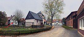
Village square in Wolperode
|
||
Wolperode is a district about five kilometers from the city center of Bad Gandersheim in a north-easterly direction, which is primarily known as a hiking destination in the region.
history
The history of Wolperode goes back to the 13th century. In 1271 the village was mentioned under the name Wolbrocheroden . In the former farming village of Wolperode, some farm positions have been given up over the past few decades, and four full-time businesses are still preserved. Today the village is also home to two restaurants, a farmer's café and a farm ice cream parlor (as of 2019).
On March 1, 1974 Wolperode was incorporated into the city of Bad Gandersheim.
Attractions
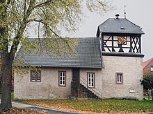
The historic village center is well preserved. The square around the church, numerous half-timbered houses and the manor are worth seeing. The village church with its massive tower and half-timbered tower dates from the 15th century.
literature
- Heinrich Medefind, with the collaboration of Werner Allewelt, Hans-Martin Arnoldt and Sabine Dorothea Pingel: The head tax description of the Principality of Braunschweig-Wolfenbüttel from 1678 (= publications of the Historical Commission for Lower Saxony and Bremen. Vol. 202). Verlag Hahnsche Buchhandlung, Hannover 2000, ISBN 3-7752-5806-X , p. 705 ff .: The court Wolperode before Gandersheim.
Individual evidence
- ^ Federal Statistical Office (ed.): Historical municipality directory for the Federal Republic of Germany. Name, border and key number changes in municipalities, counties and administrative districts from May 27, 1970 to December 31, 1982 . W. Kohlhammer GmbH, Stuttgart / Mainz 1983, ISBN 3-17-003263-1 , p. 269 .


