Wrescherode
|
Wrescherode
City of Bad Gandersheim
Coordinates: 51 ° 51 ′ 45 ″ N , 10 ° 2 ′ 23 ″ E
|
||
|---|---|---|
| Height : | 149 m | |
| Residents : | 585 (Feb. 2019) | |
| Incorporation : | March 1, 1974 | |
| Postal code : | 37581 | |
| Area code : | 05382 | |
|
Location of Wrescherode in Lower Saxony |
||
|
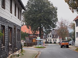
Street scene in Wrescherode (Landwehr)
|
||
Wrescherode is the second largest district of Bad Gandersheim in Lower Saxony in the Northeim district and was mentioned in writing as Writtshingerode as early as 1261.
geography
Wrescherode is two kilometers southeast of the town center of Bad Gandersheim. There is a direct connection there.
history
The so-called Haufendorf Wrescherode has always been closely related to the Gandersheim Abbey in the course of its history . On March 1, 1974, Wrescherode was incorporated into the city of Bad Gandersheim.
Infrastructure
In 1875 the volunteer fire brigade was founded in Wrescherode . Since January 1, 2019, after the local fire brigade Ellierode was affiliated as a fire fighting group to the Wrescherode fire brigade, it has around 60 active members and is the second largest fire brigade in the Bad Gandersheim urban area.
Wrescherode is the only village in the area to have a youth center. The PHOENIX was founded in 2014 and is a project of the Evangelical Collegiate Church in Bad Gandersheim.
Day care center "Hoppetosse" was founded in 1995 on the initiative of parents as a self-help kindergarten. In 2018, the sponsorship was transferred to the Johanniter-Unfall-Hilfe .
The Bad Gandersheim airfield (officially "Verkehrslandeplatz") is located in the western part of the Wrescherode district. Five aviation clubs are based there.
chapel
The chapel in the center of the village is dedicated to St. Urban and the Virgin Mary . In 1498 the chapel was given a missal , but the exact year of construction is unknown. The red paint was chosen by the members of the parish themselves.
politics
Mayor is Rene Osbahr.
Individual evidence
- ^ Federal Statistical Office (ed.): Historical municipality directory for the Federal Republic of Germany. Name, border and key number changes in municipalities, counties and administrative districts from May 27, 1970 to December 31, 1982 . W. Kohlhammer GmbH, Stuttgart / Mainz 1983, ISBN 3-17-003263-1 , p. 269 .


