List of architectural monuments in Kalefeld
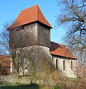
In the list of architectural monuments in Kalefeld , all listed buildings of the Lower Saxony municipality of Kalefeld (Northeim district) are listed. This list is based on the monument topography published in 2018.
General
The columns contain the following information:
- Location: the address of the monument and the geographical coordinates . Map view to set coordinates . In the map view, monuments without coordinates are shown with a red marker and can be set on the map. Architectural monuments without a picture are marked with a blue marker, architectural monuments with a picture with a green marker.
- Official name: Name of the monument
- Description: the description of the monument. Under § 3 (2) NDSchG individual monuments and under § 3 (3) NDSchG groups of structures and their components are shown.
- ID: the number of the monument
- Image: a picture of the monument
Architectural monuments
Kalefeld
| location | designation | description |
ID |
image |
|---|---|---|---|---|
| 51 ° 48 ′ 20 "N, 10 ° 2 ′ 26" E | Weißenwasser Church St. Jakobi | The desert church is located about one kilometer north of Kalefeld. The church was consecrated in 1145. |

|
|
| 51 ° 47 '50 "N, 10 ° 2' 0" E | Church of St. Nikolai and Our Lady |

|
||
| Auetalstraße 33 |
Residential building | |||
| Auetalstraße 69 |
Residential building | |||
| Eboldshäuserstraße 1 |
Mill estate | |||
| Goose plan 2 |
Residential building | |||
| Grabenstraße 12 |
Residential building | |||
| Kleiner Hagen 4 |
Parish widow house and school | |||
| Kleiner Hagen 5 |
Residential building | |||
| Mühlenstraße 9 |
Residential building | |||
| Mühlenstraße 17 |
Residential building | |||
| 51 ° 47 '53 "N, 10 ° 1' 46" E | Grosser Hagen road bridge | |||
| 51 ° 48 '13 "N, 10 ° 1' 39" E | Helleweg road bridge |
Dögerode
| location | designation | description |
ID |
image |
|---|---|---|---|---|
| At the chapel 51 ° 48 ′ 11 ″ N, 10 ° 3 ′ 43 ″ E |
chapel | |||
| Dögeroder Straße 17 51 ° 48 ′ 10 ″ N, 10 ° 3 ′ 46 ″ E |
Residential building |
Düderode
| location | designation | description |
ID |
image |
|---|---|---|---|---|
| At the sawmill 6 51 ° 48 '34 "N, 10 ° 6' 3" E |
Mansion | |||
| Düderoder Straße 13/15 51 ° 48 ′ 29 ″ N, 10 ° 6 ′ 25 ″ E |
school | |||
| Düderoder Straße 38 51 ° 48 ′ 17 ″ N, 10 ° 6 ′ 23 ″ E |
Forest homestead | |||
| Kirchgasse 3 51 ° 48 ′ 30 ″ N, 10 ° 6 ′ 27 ″ E |
church | |||
| Neuer Krug 1 51 ° 48 ′ 41 ″ N, 10 ° 5 ′ 43 ″ E |
Road money taker house | |||
| Vogelsang 1, 2 51 ° 47 ′ 39 ″ N, 10 ° 7 ′ 16 ″ E |
Vorwerk |
Eboldshausen
| location | designation | description |
ID |
image |
|---|---|---|---|---|
| At half 11 51 ° 46 ′ 39 ″ N, 10 ° 0 ′ 19 ″ E |
Residential building | |||
| At halfway point 51 ° 46 ′ 41 ″ N, 10 ° 0 ′ 15 ″ E |
Syringe house | |||
| At tub 3 51 ° 46 '30 "N, 10 ° 0' 29" E |
Dreiseithof | |||
| In the bottom 1 51 ° 46 ′ 37 ″ N, 10 ° 0 ′ 12 ″ E |
Courtyard | |||
| Mitteldorf 10 51 ° 46 ′ 32 "N, 10 ° 0 ′ 12" E |
Residential building | |||
| Thieplatz 1 51 ° 46 ′ 36 ″ N, 10 ° 0 ′ 10 ″ E |
Residential building | 33687544 | ||
| Thieplatz 2 51 ° 46 ′ 36 ″ N, 10 ° 0 ′ 12 ″ E |
church | The church was built around 1600. | 33687567 |

|
| Thieplatz 2 51 ° 46 ′ 30 ″ N, 10 ° 0 ′ 29 ″ E |
Watermill | |||
| 51 ° 46 ′ 19 ″ N, 10 ° 0 ′ 5 ″ E | Memorial to the fallen of the First and Second World Wars | 33687368 |
Real
| location | designation | description |
ID |
image |
|---|---|---|---|---|
| At the church 51 ° 47 ′ 1 ″ N, 10 ° 3 ′ 55 ″ E |
church | 33687656 |

|
|
| At church 9/11 51 ° 46 ′ 58 ″ N, 10 ° 3 ′ 55 ″ E |
Duplex house | 33687682 | ||
| Bohlweg 2 51 ° 46 ′ 54 ″ N, 10 ° 3 ′ 41 ″ E |
Residential building | 33687704 | ||
| Main Street 52 51 ° 46 ′ 55 ″ N, 10 ° 3 ′ 37 ″ E |
Residential building | 33687791 | ||
| Main Street 56 51 ° 46 ′ 54 ″ N, 10 ° 3 ′ 36 ″ E |
Residential / farm buildings | 33687816 | ||
| Hauptstrasse 28, 30/32, 34 51 ° 47 ′ 0 ″ N, 10 ° 3 ′ 37 ″ E |
Courtyard (building complex) | 33539879 | ||
| Upper Mill 2 51 ° 47 ′ 19 ″ N, 10 ° 4 ′ 12 ″ E |
Obermühle | 33687840 |

|
|
| Schulenburg 6 51 ° 46 ′ 58 ″ N, 10 ° 3 ′ 57 ″ E |
Residential building | 33687864 | ||
| 51 ° 46 ′ 37 "N, 10 ° 3 ′ 22" E | Cenotaph for the fallen of the First and Second World Wars | 33687591 | ||
| 51 ° 46 ′ 42 "N, 10 ° 3 ′ 16" E | Renninghaus grave in the cemetery | 33687609 | ||
| Milestone on the B 248 | ||||
| B 248, km 10.378 51 ° 47 ′ 21 ″ N, 10 ° 3 ′ 58 ″ E |
Road bridge | The road bridge leads over the floodplain along the B 248 . According to an inscription, it is dated to 1797. | 33687632 |
Oldershausen
| location | designation | description |
ID |
image |
|---|---|---|---|---|
| 51 ° 47 ′ 30 "N, 10 ° 5 ′ 21" E | Oldershausen Castle and Estate | The plans for the castle came from Conrad Wilhelm Hase . The castle was extended according to plans by Edwin Oppler , a pupil of Hase. |
 More pictures |
|
| Parkstraße 2 |
Gate wing | |||
| Schlossstrasse 3/5 51 ° 47 ′ 25 ″ N, 10 ° 5 ′ 24 ″ E |
Castle chapel |

|
||
| Schlossstrasse 3/5 51 ° 47 ′ 23 ″ N, 10 ° 5 ′ 22 ″ E |
Farm yard |

|
||
| Schlossstrasse 12 51 ° 47 ′ 24 ″ N, 10 ° 5 ′ 16 ″ E |
Office building |

|
||
| Schlossstrasse 7/9, 11/13, 15/17 51 ° 47 ′ 21 ″ N, 10 ° 5 ′ 16 ″ E |
Farm workers' houses | |||
| Oldwardstrasse 12 51 ° 47 ′ 40 ″ N, 10 ° 5 ′ 21 ″ E |
Residential building | |||
| Oldwardstrasse 14/16 51 ° 47 ′ 41 ″ N, 10 ° 5 ′ 23 ″ E |
Residential building | The house was built in the late 18th century. It is a two-story half-timbered house with a half-hipped roof. The house was expanded in the middle of the 19th century. |
Sebexen
| location | designation | description |
ID |
image |
|---|---|---|---|---|
| 51 ° 48 '58 "N, 10 ° 1' 27" E | Parish church |

|
||
| To church 4 51 ° 49 ′ 0 ″ N, 10 ° 1 ′ 26 ″ E |
Residential building | |||
| Angle egg 1 51 ° 48 ′ 59 ″ N, 10 ° 1 ′ 22 ″ O |
Residential building | |||
| Winkelei 13 51 ° 49 ′ 0 ″ N, 10 ° 1 ′ 22 ″ O |
Residential building | |||
| Gandersheimer Strasse 7 / Winkelei 10 51 ° 49 ′ 2 ″ N, 10 ° 1 ′ 21 ″ E |
Courtyard | |||
| Schulstrasse 11/12 51 ° 49 ′ 2 ″ N, 10 ° 1 ′ 45 ″ E |
Duplex house |
Westerhof
| location | designation | description |
ID |
image |
|---|---|---|---|---|
| Westerhöfer Strasse 1 51 ° 46 ′ 13 ″ N, 10 ° 6 ′ 55 ″ E |
Amtshof | The beginnings of the facility can be traced back to the end of the 13th century. It was first mentioned in 1294 as Castrum Westerhofe . |
 More pictures |
|
| Koerberberg 10 51 ° 46 ′ 9 ″ N, 10 ° 6 ′ 53 ″ E |
Chapel of Ortisei | |||
| Westerhöfer Straße 2/4 |
District Court | |||
| Schulgasse 2 51 ° 46 ′ 8 ″ N, 10 ° 6 ′ 55 ″ E |
school | |||
| Westerhöfer Straße 21 |
Residential building | |||
| Westerhöfer Straße 23 |
Residential building | |||
| Westerhöfer Straße 28, 30 33 |
Residential houses | |||
| Westerhöfer Straße 12 |
Residential building | |||
| Westerhöfer Straße 10 |
Residential building | |||
| Teichmühle 1 51 ° 46 '38 "N, 10 ° 6' 45" O |
Pond mill | |||
| Tunnel portal | The portal was completed in 1901. It is part of the Kreiensen – Osterode small train line . |
Wiershausen
| location | designation | description |
ID |
image |
|---|---|---|---|---|
| 51 ° 49 ′ 33 "N, 10 ° 4 ′ 12" E | chapel |

|
Willershausen
| location | designation | description |
ID |
image |
|---|---|---|---|---|
| Am Edelhof 8 51 ° 46 ′ 49 ″ N, 10 ° 6 ′ 24 ″ E |
Estate | The former manor was first mentioned in 1342, when the landlords were the lords of Westerhof. Originally the complex was a moated castle, which was rebuilt in 1727. | ||
| Am Kirchberg 4 51 ° 46 ′ 53 ″ N, 10 ° 6 ′ 33 ″ E |
church |

|
||
| At Kirchweg 6 51 ° 46 ′ 54 ″ N, 10 ° 6 ′ 32 ″ E |
Rectory |
literature
- Monument topography Federal Republic of Germany, architectural monuments in Lower Saxony, Volume 7.2, Nordheim district - northern part with the cities of Bad Gandersheim and Dassel, the districts of the city of Einbeck and the municipality of Kalefeld, edited by Christian Kämmerer, Thomas Kellermann, Peter Ferdinand Lufen, edited by Christina Krafczyk , E. Reinhold Verlag, Altenburg 2018, ISBN 978-3-95755-040-8 , pp. 614-638.
Web links
Commons : Architectural monuments in Kalefeld - Collection of images, videos and audio files


