
Kalefeld
| coat of arms | Germany map | |
|---|---|---|

|
Coordinates: 51 ° 48 ' N , 10 ° 2' E |
|
| Basic data | ||
| State : | Lower Saxony | |
| County : | Northeim | |
| Height : | 125 m above sea level NHN | |
| Area : | 84.17 km 2 | |
| Residents: | 6231 (Dec. 31, 2019) | |
| Population density : | 74 inhabitants per km 2 | |
| Postal code : | 37589 | |
| Area code : | 05553 | |
| License plate : | NOM, EIN, GAN | |
| Community key : | 03 1 55 006 | |
| LOCODE : | DE YRW | |
| Community structure: | 11 districts | |
| Address of the municipal administration: |
Kleiner Hagen 4 37589 Kalefeld |
|
| Website : | ||
| Mayor : | Jens Meyer ( SPD ) | |
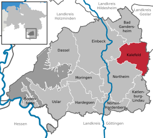
| Location of the municipality of Kalefeld in the Northeim district | ||
  |
||

Kalefeld is a municipality in the Northeim district in Lower Saxony .
geography
location
The municipality of Kalefeld is located between Harz and Solling near the Aue (Leine) in southern Lower Saxony.
The total area of the municipality of Kalefeld is 84.10 km², 39 percent of which is used for forestry.
Community structure
It consists of the following districts:
|
Neighboring communities
- the cities of Northeim , Einbeck , Bad Gandersheim , Seesen , Osterode am Harz
- the municipalities of Bad Grund (Harz) and Katlenburg-Lindau
history
Kalefeld was first mentioned in 889 in a document from Emperor Arnulf of Carinthia .
In the Thirty Years 'War and the Seven Years' War , there was destruction.
Place name
Old names of the place are around 889 Halafeld, 1254 Caleuelde, 1256 Caluelde, 1283 Calevelde, 1297 Calvelde and 1297 Calvelde. Since place names formed with the basic word “-feld” often contain a water body name in the identifier, the question arises whether such a name can also be assumed in Kalefeld. The location of the place on the floodplain allows the assumption of an old section name of this river. In that case, the Germanic form of this river name is likely to be "Kal-a-", although the meaning of this term is not known. Possibly means “kala” (“to be cold, freezing”), “calan” (“cool”), “kul” (“cool breeze”) or “kal” (“cold wind”). In this case, the name would be given by the temperature of the water.
Incorporations
The municipality of Kalefeld was enlarged on March 1, 1974 by the municipality reform through the integration of the formerly independent municipalities Dögerode, Düderode, Eboldshausen, Echte, Oldenrode, Oldershausen, Sebexen, Westerhof, Wiershausen and Willershausen, which belonged to the old Westerhof office . The old Westerhof office was temporarily assigned to the Osterode office.
politics
Municipal council
After the local elections on September 11, 2016, the council of the municipality has 18 members. He also has the full-time mayor.
| Party / list | SPD | CDU | FWG | Green | FDP | total |
| Seats 2006 | 11 | 8th | - | - | 1 | 20 seats |
| Seats 2011 | 7th | 6th | 4th | 1 | - | 18 seats |
| Seats 2016 | 7th | 5 | 5 | 1 | - | 18 seats |
mayor
Mayor is Jens Meyer (SPD), council chairman Otto Gropp (SPD).
coat of arms
The coat of arms contains the Oldershausen rose.
Culture and sights
Buildings

- In 1872 the Evangelical Church of Our Lady was built on the site of a chapel demolished in 1870 according to plans by Conrad Wilhelm Hase . It is a three-aisled hall church in the neo-Gothic style. The roof of this brick church is covered with zinc sheet. The church has a three-part ringing made of bronze bells, which was cast in 1956 by the renowned Otto bell foundry from Bremen-Hemelingen. The strike tone series is g, h, c. The bells have the following diameters: 1016 mm, 813 mm, 761 mm and weigh 650 kg, 340, 260 kg.
- The former Catholic Church of St. Jakobus the Elder on Auetalstrasse was built in 1960/61, and since 2004 it has belonged to the parish of the Visitation of Mary in Northeim. In 2015 it was profaned and sold to private customers.
- Westerhof Castle : late medieval castle complex and seat of the bailiff in the Westerhof district
- Weißenwasserkirche : Romanesque church in the Weißenwasser desert northeast of Kalefeld
Roman battlefield
Legacies of a battle between Teutons and Romans in the 3rd century were discovered in the municipality of Kalefeld in the 21st century. The discovery surprised the archaeological experts, as Kalefeld is comparatively far removed from the Roman areas on the other side of the Limes . The location of the military conflict at that time is assigned to a relatively late phase of the Roman Empire. A selection of the objects has been exhibited in the Braunschweig State Museum since 2013 . On the original site, a ground monument near Oldenrode , there are regular guided tours organized by the tourist office in Bad Gandersheim .
Economy and Infrastructure
traffic
The community lies on the B 445 and B 248 and is divided by the A 7 . The federal motorway exit No. 68 Echte is located in the municipality . Kalefeld station was on the Osterode – Kreiensen railway line . This is shut down.
education
The municipality of Kalefeld maintains a primary school in the village of Echte . Furthermore, the "Auetalschule" (secondary and secondary school) is located in the village of Kalefeld and is supported by the Northeim district .
Former schools:
- Sebexen Primary School
- Elementary School Düderode
Personalities
- Philipp Christian Friedrich Bodecker (1756–1845), from 1794 to 1841 head of the Oldenburg forest administration
- Juliane von Hessen-Darmstadt (1606–1659) bought Westerhof Castle in 1654 and died there
- Sabine Hamer (* 1953), politician (SPD)
Web links
Individual evidence
- ↑ State Office for Statistics Lower Saxony, LSN-Online regional database, Table 12411: Update of the population, as of December 31, 2019 ( help ).
- ^ Jürgen Udolph (research): The "place name researcher". In: website NDR 1 Lower Saxony . Archived from the original on December 2, 2016 ; accessed on March 10, 2019 .
- ^ Federal Statistical Office (ed.): Historical municipality directory for the Federal Republic of Germany. Name, border and key number changes in municipalities, counties and administrative districts from May 27, 1970 to December 31, 1982 . W. Kohlhammer, Stuttgart / Mainz 1983, ISBN 3-17-003263-1 , p. 216 .
- ^ Conrad Wilhelm Hase, work catalog, Kalefeld / Calefeld
- ^ Gerhard Reinhold: Otto bells. Company and family history of the Otto bell foundry dynasty . Self-published, Essen 2019, ISBN 978-3-00-063109-2 , p. 588, here in particular p. 555 .
- ↑ Gerhard Reinhold: Church bells - Christian world cultural heritage, illustrated using the example of the bell founder Otto, Hemelingen / Bremen . Nijmegen / NL 2019, p. 556, here in particular p. 509 , urn : nbn: nl: ui: 22-2066 / 204770 (doctoral thesis at Radboud University Nijmegen).
Bad Gandersheim | Bodenfelde | Dassel | Einbeck | Hardegsen | Kalefeld | Katlenburg-Lindau | Moringen | Nörten-Hardenberg | Northeim | Uslar
Community-free area in the Northeim
Solling district
Dögerode | Düderode | Eboldshausen | Real | Oldenrode | Oldershausen | Sebexen | Westerhof | Wiershausen | Willershausen