List of architectural monuments in Katlenburg-Lindau
In the list of architectural monuments in Katlenburg-Lindau , all listed buildings of the Lower Saxon community Katlenburg-Lindau ( Northeim district ) are listed. The list was as of 2002.
General
The community Katlenburg-Lindau was established in 1974. The monuments are located in the districts of Berka , Elvershausen , Gillersheim , Katlenburg , Lindau , Suterode and Wachenhausen .
The columns contain the following information:
- Location: the address of the monument and the geographical coordinates . Map view to set coordinates . In the map view, monuments without coordinates are shown with a red marker and can be set on the map. Architectural monuments without a picture are marked with a blue marker, architectural monuments with a picture with a green marker.
- Official name: Name of the monument
- Description: the description of the monument. Under § 3 (2) NDSchG individual monuments and under § 3 (3) NDSchG groups of structures and their components are shown.
- ID: the number of the monument
- Image: a picture of the monument
Berka
| location | designation | description |
ID |
image |
|---|---|---|---|---|
| Kirchplatz 3 51 ° 41 ′ 12 ″ N, 10 ° 6 ′ 37 ″ E |
Residential building |

|
||
| Kirchplatz 8 51 ° 40 ′ 58 ″ N, 10 ° 6 ′ 36 ″ E |
church | The Protestant Church of St. Martini was built from 1779 to 1784 on a rubble stone base. The quarry stone base dates from the late Middle Ages. To the west of the church is the tower with a lantern dome. |

|
|
| Highway 2/4 51 ° 41 ′ 12 ″ N, 10 ° 6 ′ 37 ″ E |
House and substation |

|
||
| Long row 45 51 ° 41 ′ 17 ″ N, 10 ° 6 ′ 45 ″ O |
Residential building |

|
||
| To Rhumetor 6 51 ° 41 ′ 14 ″ N, 10 ° 6 ′ 34 ″ E |
Residential building |

|
||
| To Stöntor 2 51 ° 41 ′ 5 ″ N, 10 ° 6 ′ 32 ″ E |
Residential building |

|
Elvershausen
| location | designation | description |
ID |
image |
|---|---|---|---|---|
| at Kirchberg |
church | The Evangelical Church of St. Valentin was built in the early 16th century. In 1705 the church was rebuilt. |

|
|
| On Damme 1 51 ° 42 ′ 21 ″ N, 10 ° 5 ′ 51 ″ E |
Residential building | |||
| Dorfstrasse 12 51 ° 42 ′ 23 ″ N, 10 ° 5 ′ 48 ″ E |
Inn | |||
| Mandelbecker Straße 3 |
Residential building | |||
| Mühlengasse 2 |
Residential building | |||
| Taake 3 |
Residential building | |||
| Taake 6 |
Residential building |
Gillersheim
| location | designation | description |
ID |
image |
|---|---|---|---|---|
| Gillersheimer Forst 51 ° 37 ′ 46 ″ N, 10 ° 2 ′ 41 ″ E |
Desert Church | The ruins of the Church of St. Johannes in the Leisenberg desert were built around 1300. The gable walls and remains of the longitudinal walls have been preserved. There is a pointed arch window in the eastern gable wall. There was probably no tower. The settlement was abandoned in the middle of the 15th century. |

|
|
| Glockenberg 9 |
Forester's house | |||
| Glockenberg 14 |
Residential building | |||
| Kirchstrasse 51 ° 38 ′ 2 ″ N, 10 ° 5 ′ 32 ″ E |
church | Neo-Romanesque hall church, built 1852–54 |

|
|
| Lehmkuhle 2 |
Bakehouse | |||
| Upper street 2 |
Residential building |
Katlenburg
| location | designation | description |
ID |
image |
|---|---|---|---|---|
| Albrechtshausen 51 ° 40 ′ 19 ″ N, 10 ° 7 ′ 42 ″ E |
domain |

|
||
| Castle Hill 51 ° 40 ′ 38 ″ N, 10 ° 6 ′ 1 ″ E |
church | The Protestant Church of St. John was built between 1647 and 1650. The previous building was destroyed in 1626. |

|
|
|
Castle Hill 51 ° 40 ′ 37 ″ N, 10 ° 6 ′ 2 ″ E |
"Castle" |

|
||
| Castle Hill 51 ° 40 ′ 40 ″ N, 10 ° 6 ′ 2 ″ E |
Magazine building |

|
||
| Castle Hill 51 ° 40 ′ 35 ″ N, 10 ° 6 ′ 1 ″ E |
Residential building | |||
| Herzberger Strasse 51 ° 40 ′ 52 ″ N, 10 ° 5 ′ 54 ″ E |
Cemetery chapel |

|
||
| Herzberger Strasse 23 51 ° 40 ′ 44 ″ N, 10 ° 6 ′ 4 ″ E |
Rectory | The rectory was built around 1800. |

|
|
| Herzberger Strasse 26 51 ° 40 ′ 48 ″ N, 10 ° 5 ′ 57 ″ E |
Residential building |

|
||
| Herzberger Strasse 27 51 ° 40 ′ 40 ″ N, 10 ° 6 ′ 5 ″ E |
Mill | The watermill was first mentioned in 1326. At that time the mill belonged to the Katlenburg monastery. |

|
|
| Klosterhof 1 51 ° 40 ′ 46 ″ N, 10 ° 6 ′ 6 ″ E |
Residential building |

|
||
| Klosterhof 2 51 ° 40 ′ 47 ″ N, 10 ° 6 ′ 4 ″ E |
Residential building | |||
| Klosterhof 3 51 ° 40 ′ 46 ″ N, 10 ° 6 ′ 5 ″ E |
Residential building |

|
||
| Northeimer Strasse 1 51 ° 40 ′ 58 ″ N, 10 ° 5 ′ 57 ″ E |
Residential building |

|
||
| Northeimer Strasse 21 51 ° 41 ′ 11 ″ N, 10 ° 5 ′ 50 ″ E |
Residential building |

|
||
| Suteroder Strasse 1 51 ° 40 ′ 46 ″ N, 10 ° 5 ′ 57 ″ E |
Residential building |

|
Lindau
| location | designation | description |
ID |
image |
|---|---|---|---|---|
| Bischof-Diederich-Platz 51 ° 39 ′ 14 ″ N, 10 ° 7 ′ 30 ″ E |
church | Catholic Church of St. Peter and Paul . The tower dates from 1523. The foundation stone for the church as we know it today was laid in 1755. |

|
|
| Brückenstrasse 51 ° 39 ′ 9 ″ N, 10 ° 7 ′ 23 ″ E |
so-called mushaus |

|
||
| Federal highway 41 51 ° 39 ′ 18 ″ N, 10 ° 7 ′ 26 ″ E |
Kreuzkirche | The Kreuzkirche was built in 1895, the design comes from Conrad Wilhelm Hase . It is a brick church with historical shapes. The church is located directly on the B 247 . |

|
|
| Federal highway 86 51 ° 39 ′ 10 ″ N, 10 ° 7 ′ 44 ″ E |
Residential building | |||
| Fleckenstrasse 8 51 ° 39 ′ 14 ″ N, 10 ° 7 ′ 22 ″ E |
Rectory | Detached two-storey half-timbered house without protrusion from the end of the 18th century |

|
|
| Cemetery 51 ° 39 ′ 15 ″ N, 10 ° 7 ′ 39 ″ E |
crucifix | |||
| Marienplatz 51 ° 39 ′ 13 ″ N, 10 ° 7 ′ 9 ″ E |
Virgin Mary statue | Marian column in memory of the fire of 1911 |

|
|
| Markt 8 51 ° 39 ′ 13 ″ N, 10 ° 7 ′ 29 ″ E |
Inn | Former guest house in a prominent location. Probably built in the first half of the 18th century as a two-story half-timbered building with a slight protrusion. The parapet compartments are highlighted with St. Andrew's crosses, the corners with K-struts, the corner posts have carvings in the form of twisted quarter columns. |

|
|
| Marktstraße 2 |
Residential building | |||
| Marktstraße 4 |
Residential building | |||
| Marktstraße 6 |
Residential building | |||
| Marktstrasse 8 51 ° 39 ′ 12 ″ N, 10 ° 7 ′ 28 ″ E |
Residential building | |||
| Sackstraße 3 |
Residential building | |||
| Torstrasse 5 |
Residential building |
Suterode
Group: chapel and former school
The group chapel and former school has the ID 33540103.
| location | designation | description |
ID |
image |
|---|---|---|---|---|
| Lower Street 51 ° 40 ′ 14 ″ N, 10 ° 3 ′ 47 ″ E |
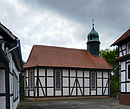
chapel | Half-timbered chapel, built in 1787 on a hill in the village. Simple hall construction with polygonal choir closure and high segment arched windows. At the western end of the roof there is a narrow slate roof turret with a sheet metal-covered Welsch hood | 33540103 |

|
| Lower Street 17 51 ° 40 ′ 15 ″ N, 10 ° 3 ′ 47 ″ E |
former school | 33691548 | ||
| Lower Street 17 a 51 ° 40 ′ 15 ″ N, 10 ° 3 ′ 48 ″ E |
former school | 33691569 |
Wachenhausen
| location | designation | description |
ID |
image |
|---|---|---|---|---|
| Hauptstrasse 30 51 ° 39 ′ 59 ″ N, 10 ° 5 ′ 46 ″ E |
court | 33691590 | ||
| Oberdorfstrasse 8 51 ° 39 ′ 54 ″ N, 10 ° 5 ′ 40 ″ E |
Residential / farm buildings | 33691613 |
literature
- Monument topography Federal Republic of Germany, architectural monuments in Lower Saxony, Northeim district, Volume 7.1, 2002, edited by Christian Kämmerer and Peter Ferdinand Lufen, edited by Christiane Segers-Glocke, Verlag CW Niemeyer Buchverlage , Hameln, ISBN 3-8271-8261-1
Web links
Commons : Cultural heritage monuments in Katlenburg-Lindau - Collection of images, videos and audio files

