Gillersheim
|
Gillersheim
Community Katlenburg-Lindau
|
||
|---|---|---|
| Coordinates: 51 ° 38 ′ 3 ″ N , 10 ° 5 ′ 35 ″ E | ||
| Height : | 169 m above sea level NHN | |
| Area : | 18.91 km² | |
| Residents : | 970 (Jul 1, 2018) | |
| Population density : | 51 inhabitants / km² | |
| Incorporation : | March 1, 1974 | |
| Postal code : | 37191 | |
| Area code : | 05556 | |
|
Location of Gillersheim in Lower Saxony |
||
|
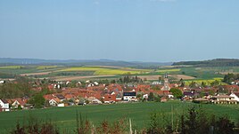
Town view from the west
|
||
Gillersheim is a village with 970 inhabitants in southern Lower Saxony . Gillersheim belongs to the municipality of Katlenburg-Lindau and thus to the district of Northeim . With an area of 18.91 km², Gillersheim is the largest town in the municipality in terms of area and the third largest in terms of population.
The inhabitants are also jokingly called "cuckoos", although the exact origin and meaning of this nickname is unclear. The place celebrated its 900th anniversary in 2005 and is known for its numerous club activities and its volunteer fire brigade . The village has already successfully participated in the competition "Our village should be more beautiful - our village has a future".
geography
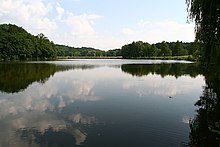
About two kilometers south of Gillersheim is the recreation and nature reserve " Thiershäuser Teiche " and the Rhumeaue / Ellerniederung / Gillersheimer Bachtal nature reserve begins just to the east .
history
The place was first mentioned in a document in 1105 under the name Geldrikesen . This happened in the context of a forged document, which Archbishop Ruthard of Mainz issued on November 11, 1105 in Katlenburg . In this document he confirmed the founding of the Katlenburg monastery, which Count Dietrich von Katlenburg built on his castle and equipped with numerous goods. At this time Gillersheim was under the sovereignty of the County of Northeim , which counted the place as an allod to their property. The written sources speak of alii compagenses , which suggests a trace back to the Counts of Northeim. In the 14th century the place was under the principality of Grubenhagen , the dukes, Ernst , Wilhelm and Johann sold on March 6, 1323 the village of Gillersheim, Wollbrechtshausen, the county of Westerhof and the court of Berka on repurchase to the Hildesheim bishop Otto . Almost 350 years later a conflagration struck the place, 32 houses were victims of the flames next to the Feldmark of the former village Wollbrechtshausen. Some of the residents of Wollbrechtshausen moved to Gillersheim. In the following years there was a gradual recovery. In Gillersheim, which at the time was part of the Katlenburg-Lindau office and the associated Katlenburg bailiwick in 1848, with the local Angermühle, a total of 812 inhabitants were counted, spread over 138 houses. At the beginning of the 19th century, the village was placed under the canton of Northeim, which was part of the Göttingen district . The Lutheran parish village at that time had 630 residents in its 121 houses.
In the course of the regional reform in Lower Saxony , the community of Gillersheim lost its political independence on March 1, 1974 and was incorporated into the new community of Katlenburg-Lindau.
politics
Local council
The local council of Gillersheim consists of 11 council members from the following parties:
- SPD : 6 seats
- CDU : 4 seats
- Free voter community (FWG) : 1 seat
(Status: local election September 11, 2016)
Local mayor
- Local Mayor : Uwe Lebensieg (SPD)
- 1st Deputy Mayor: Gardi Müller (CDU)
- 2nd Deputy Mayor: Alexandra Ehrlich (SPD)
(Source:)
coat of arms
|
Blazon : "In the split shield in front in red a half silver armored black eagle at the crack, behind in silver a green oak branch with two golden acorns ."
The coat of arms was heraldically incorrectly made in its front field ( see: Tinging - Heraldic color rules ). |
|
| Foundation of the coat of arms: Gillersheim belonged to the Katlenburg office. It has an extensive forest area, which is of great economic importance for the place. The official coat of arms is used because other heraldic peculiarities of the place are not known. |
Culture and sights
Historical sights are the deserted Leisenberg with church ruins and the barrows in the extensive forest areas of Gillersheim.
Personalities
People connected to the place
- Frauke Heiligenstadt (* 1966), politician (SPD), member of the state parliament and former Lower Saxony minister of education, lives in Gillersheim
Web links
Individual evidence
- ↑ a b c Figures, data, facts. In: Website of the municipality of Katlenburg-Lindau. July 1, 2018, accessed November 27, 2019 .
- ↑ Manfred Voith (Ed.): Mainzer Urkundenbuch 424 . tape 1 , 1932.
- ^ Gudrun Pischke: areas of rule of the Billunger, the Counts of Stade, the Counts of Northeim and Lothars of Süpplingenburg . August Lax Verlag, Hildesheim 1984, ISBN 3-7848-2004-2 .
- ↑ Hans Sudendorf (Ed.): Document book on the history of the dukes of Braunschweig and Lüneburg and their lands - Part 1: Until 1341 . No. 374 . Rümpler Verlag, Hanover 1859, p. 211 .
- ↑ Friedrich Wilhelm Harseim, C. Schlüter: Statistical Manual for the Kingdom of Hanover (= Statistical Manuals for the Kingdom of Hanover ). Schlüter'sche Hofbuchdruckerei, Hanover 1848, p. 80 ( digitized in the Google book search).
- ^ Johann Georg Heinrich Hassel: Statistical Repertory on the Kingdom of Westphalia . Vieweg Verlag, Braunschweig 1813, p. 19 .
- ^ Federal Statistical Office (ed.): Historical municipality directory for the Federal Republic of Germany. Name, border and key number changes in municipalities, counties and administrative districts from May 27, 1970 to December 31, 1982 . W. Kohlhammer, Stuttgart / Mainz 1983, ISBN 3-17-003263-1 , p. 214 .
- ↑ a b Members of the Gillersheim local council. In: Website of the municipality of Katlenburg-Lindau. Retrieved November 27, 2019 .
- ↑ Gillersheim coat of arms. In: Website of the municipality of Katlenburg-Lindau. Retrieved November 27, 2019 .


