
List of cultural monuments in the southern part of the city (Kassel)
The list of cultural monuments in the southern part of the city contains all the cultural monuments in the southern part of the city , one of the 23 parts of the municipality of the independent city of Kassel , which were published in the monument topography published by the State Office for Monument Preservation Hesse in 1983 (city of Kassel I) and 2005 (city of Kassel II) .
Legend
- Name: gives the name, the description or the type of the cultural monument.
- Location: States the street name and, if available, the house number of the cultural monument. The list is basically sorted according to this address. The link "Map" leads to various map displays and gives the coordinates of the cultural monument.
- Description: Provides structural and historical details of the cultural monument, preferably the characteristics of the monument. The reason for the monument value should be given in abbreviated form in brackets: g = historical, k = artistic, s = urban development, t = technical, w = scientific.
- Construction time: indicates the date; the year of completion or the period of construction. Sorting by year is possible.
Monument list Südstadt
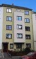
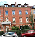
Complete facility at Akademiestrasse
| image | designation | location | description | construction time | Data |
|---|---|---|---|---|---|
  |
Complete facility at Akademiestrasse | Akademiestrasse 6, 8-12, 9-17; Menzelstrasse 8 and 14 location |
Two-part residential complex without identified individual monuments (g, k) | from 1908 to the end of the 1920s |
Complete garden city of Auefeld
| image | designation | location | description | construction time | Data |
|---|---|---|---|---|---|
 |
Complete garden city of Auefeld | Am Auekamp 1–31, 2–44; At the garden 1–23, 2–18; Brückner-Kühner-Platz; Eberhardt-Wildermuth-Strasse 1-79, 2-100; Erich-Klabunde-Strasse 1–131, 2–34; Hans-Böckler-Strasse 1–95, 2–28; Heinrich-Heine-Strasse 27, 29, 31, 33; Ludwig-Mond-Strasse 60–90; Richard-Wagner-Strasse 2–6a, 21–27 | Settlement planned as a garden city with single and multi-family houses (g, k) | Start of construction 1955, inauguration of the 1st construction phase 1957, 2nd construction phase 1960, gymnasium 1975 | |
 |
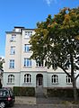
St. Mark's Church | Richard-Wagner-Straße 6 Location hallway: 10, parcel: 6 |
Church building with a free-standing bell tower (g, k, s) | 1960 |
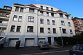
Complete facility at Frankfurter Strasse I / Beethovenstrasse
| image | designation | location | description | construction time | Data |
|---|---|---|---|---|---|
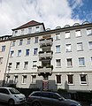
| Complete facility at Frankfurter Strasse I / Beethovenstrasse | Beethovenstrasse 1; Frankfurter Strasse 115a, 117, 119, 123-141b | Apartment buildings, restaurants and sports facilities, but the cycling track is no longer preserved (g) | around 1900 | ||
 |
Corner house Beethovenstrasse 1 | Beethovenstrasse 1 position corridor 52, parcel: 4/2 |
Five-storey corner house with restaurant (s) | 1904 | |
 |
Residential and commercial building | Frankfurter Straße 119 Location hallway: 52, parcel: 4/1 |
Five-storey residential and commercial building (s) | 1904 | |
 |
Residential and commercial building | Frankfurter Straße 129 Location hallway: 52, parcel: 8/19 |
Large five-story residential and commercial building (k, s) | 1907 | |
 |
Residential and commercial building | Frankfurter Straße 131 Location hall: 52, parcel: 8/7 |
Five-story residential and commercial building, sports facility restaurant behind the building (g, s) | 1893 | |
| Sports facilities | Frankfurter Strasse 131 | Sports facilities at Frankfurter Strasse 131, a former racing track for cyclists from 1894, leveled in 1902, house 131 served as the sports facility's restaurant | 1894 | ||
 |
Residential building | Frankfurter Straße 137 Location hallway: 52, parcel: 8/3 |
Five-story residential building with pub (s) | 1904/05 | |
 |
Residential and commercial building | Frankfurter Straße 139 Location hallway: 52, parcel: 8/2 |
Five-storey residential and commercial building (s) | 1905 | |
 |
Residential and commercial building | Frankfurter Straße 141 Location hall: 52, parcel: 8/18 |
Five-storey residential and commercial building (k, s) | 1905 |
- Monuments of the entire complex at Frankfurter Strasse I / Beethovenstrasse without their own entry in the topography

Residential building at Frankfurter Strasse 115a

Residential building at Frankfurter Strasse 117


Entire facility at Frankfurter Strasse II
| image | designation | location | description | construction time | Data |
|---|---|---|---|---|---|
 |
Entire facility at Frankfurter Strasse II | Frankfurter Strasse 153, 155, 157, 159 (with rear buildings) | Residential and commercial buildings on the east side of Frankfurter Strasse (g) | 1905-1907 | |
 |
Residential and commercial building | Frankfurter Straße 153 Location hall: 52, parcel: 36/1 |
Four-storey residential and commercial building with pub (s) | 1906 | |
 |
Residential and commercial building | Frankfurter Straße 155 Location hall: 52, parcel: 36/2 |
Four-storey residential and commercial building (s) | 1907 | |
 |
Residential and commercial building | Frankfurter Straße 157 Location hall: 52, parcel: 37/3 |
Four-storey residential and commercial building with pub (s) | 1905 |
- Monuments of the entire Frankfurter Straße II complex without their own entry in the topography

Residential and commercial building at Frankfurter Strasse 159

Complete system at Heckerstraße / Südstadt
| image | designation | location | description | construction time | Data |
|---|---|---|---|---|---|
 |
Complete system at Heckerstraße / Südstadt | At Karlsaue 7; Heckerstrasse 32-38, 73-87; Johannesstrasse 1–7, 2–8; Julienstraße 2-8, 3-7; Landaustrasse 1-5, 2, 4, 10-22; Milchlingstrasse 6 location |
Wilhelminian style residential area (g) | from the mid-1880s | |
 |
villa | Heckerstraße 32 Location hall: 8, parcel: 600/53 |
Two-storey, neo-Gothic villa in the style of the Hanover School (g, k, s) | until 1887 | |
 |
Corner house | Heckerstraße 71 Location hallway: 8, parcel: 577/19 |
Originally a five-storey corner house (s) today | 1904 | |
 |
Residential building | Heckerstraße 87 Location hallway: 8, parcel: 467/53 |
Three-storey residential building (k, s) | around 1898 | |
 |
Residential building | Johannesstraße 2 Location hallway: 8, parcel: 536/52 |
Three-storey, historically designed house (s) | around 1903 | |
 |
Residential building | Johannesstraße 3 Location hallway: 8, parcel: 395/52 |
Three-storey, historicist house (s) | before 1898 | |
 |
Residential building | Johannesstraße 5 Location hallway: 8, parcel: 597/52 |
Three-storey residential building (k, s) | 1905 | |
 |
Corner building | Johannesstraße 7 Location hallway: 8, parcel: 598/52 |
Three-story corner building (k, s) | around 1905 | |
 |
Residential houses | Julienstraße 3 and 5 Location hall: 8, parcel: 362/52 (No. 3), 361/52 (No. 5) |
Cottage-like, detached, two-storey residential buildings (s) | around 1896 | |
 |
Residential building | Julienstraße 4 Location hall: 8, parcel: 532/52 |
Art Nouveau residential building (k, s) | between 1903 and 1905 | |
 |
Residential building | Julienstraße 7 Location hall: 8, parcel: 599/53 |
Detached house (s) | around 1905 | |
 |
Corner house | Julienstraße 8 Location hallway: 8, parcel: 539/52 |
Three-story corner house (s) | around 1903 | |
 |
Residential building | Landaustraße 12 Location hallway: 8, parcel: 735/52 and 736/52 |
Three-storey residential building (s) | around 1905 | |
 |
Residential and commercial building | Landaustraße 13 Location hall: 8, parcel: 634/52 |
Wilhelminian style residential and commercial building (g, s) | 1902 | |
 |
Residential building | Landaustrasse 16 Location hallway: 8, parcel: 588/52 |
Three-storey residential building (s) | 1905 | |
 |
Residential building | Landaustraße 18 Location hallway: 8, parcel: 589/52 |
Three-storey residential building (k, s) | 1905 |
- Monuments of the entire Heckerstraße / Südstadt complex without their own entry in the topography

House at Karlsaue 7

House in Milchlingstrasse 6

House at Heckerstraße 34

House at Heckerstraße 36

House at Heckerstraße 38

House at Heckerstraße 73

House at Heckerstraße 75

House at Heckerstraße 77

House at Heckerstraße 79

House at Heckerstraße 83

House at Heckerstraße 85

Residential building Johannesstrasse 1

Residential building Johannesstrasse 4

House Johannesstrasse 6

Residential building Johannesstrasse 8

Residential building Julienstraße 2

Residential building Julienstraße 6

Residential building Landaustraße 1

House Landaustraße 2

House Landaustraße 3

House Landaustraße 4

House Landaustraße 5

Residential house Landaustraße 10

House Landaustraße 14

Residential house Landaustraße 20

Residential house Landaustraße 22


Complete system at Heinrich-Heine-Strasse
| image | designation | location | description | construction time | Data |
|---|---|---|---|---|---|
 |
Complete system at Heinrich-Heine-Strasse | Heinrich-Heine-Strasse 3, 4, 5, 6, 8, 10, 16 location |
Residential street (g) | House No. 3 1857, No. 5 1872, further expansion of the street from the mid-1880s | |
 |
Residential building | Heinrich-Heine-Straße 3 Location hallway: 8, parcel: 39/1 |
Half-timbered house with eaves, extensions on the back (g, s) | 1857 | |
 |
Former garden shed | Heinrich-Heine-Straße 5 Location hallway: 8, parcel: 36/30 |
Plastered half-timbered building, once the garden house of the "Auekrug" restaurant, which is no longer preserved (g, s) | 1872 |
- Monuments of the entire Heinrich-Heine-Straße complex without their own entry in the topography

Residential building Heinrich-Heine-Strasse 4

House at Heinrich-Heine-Strasse 6
Residential building Heinrich-Heine-Strasse 8

Residential building Heinrich-Heine-Strasse 10
Residential building Heinrich-Heine-Straße 16


Universe Karlsaue
| image | designation | location | description | construction time | Data |
|---|---|---|---|---|---|
 more pictures |
Karlsaue | along the Fulda location corridor: GI, parcel: |
Garden area | around 1568 | |
|
more pictures |
Orangery | At Karlsaue 20c, corridor location : GI, parcel: 55/4 |
Orangery , architects Johann Conrad Giesler and later Simon Louis du Ry | from 1703 | |
 |
Marble bathroom | At Karlsaue 20, corridor location : GI, parcel: 66/4 |
Representative bathing complex from the late baroque period | 1722-1730 | |
 |
Kitchen pavilion | At Karlsaue 20, corridor location : GI, parcel: 66/4 |
Pavilion, architect Simon Louis du Ry | 1882 | |
 |
Marble Bath Bridge | Auedamm, by the marble bathroom location |
Bridge, architect Simon Louis du Ry (g, k) | 1792 | |
 |
Garden management | Auedamm 18 (three buildings) Corridor location : GI, parcel: 21/7 |
Administration building | after 1950 | |
 |
Parking attendant house | Auedamm 58 Corridor location : GI, parcel: 27 |
Residential building | 1766 | |
 |
Hessen lion | Gustav Mahler stairs location |
Lion sculpture, sculptor Gustav Kaupert (g, k) | 1874 | |
 |
Parking attendant house | Heinrich-Heine-Straße 1 Location hallway: 7, parcel: 32/1 |
Residential house, built as a replacement for a previous building from the 18th century based on the house Auedamm 58 (g, k, s) | 1837 | |
 |
"Aueportal" park gate | Heinrich-Heine-Straße o. No. Location floor: 7, parcel: 21/16 |
Gate, original location at the orangery, 1825 and moved after 1945 (g, k) | 1766 | |
 |
Temple on Swan Island | Karlsaue location corridor: GI, parcel: 30 |
Classicist temple | Early 19th century | |
 |
Kurhessische war memorial site | Karlsaue location Corridor: GI, parcel: 41/4 |
War memorial , architect H. Sautter (g, k) | 1922 (consecration), 1955 (reconstruction) | |
 more pictures |
Breakfast pavilion | Nice view (actual location), Karlsaue (location according to monument topography) Corridor location : E II, parcel: 55/5 |
Pavilion, part of the gardens of Bellevue Palace, architect Daniel Engelhard (k, s) | before 1815, 2013 (restoration) | |
 |
Bridge over the Kleine Fulda ("Löwenbrücke") | between today's regional council and Fuldaaue Lage |
Bridge (k) | around 1813 |
Complete complex in Mozartstrasse
| image | designation | location | description | construction time | Data |
|---|---|---|---|---|---|
 |
Complete complex in Mozartstrasse | Frankfurter Strasse 87, 89, 91; Mozartstrasse 1, 2, 3, 4, 5, 7 location |
Street with housing developments | from 1904 | |
 |
Tenement house | Frankfurter Straße 87 Location hall: 8, parcel: 36/27 |
Five story | around 1906 | |
 |
Residential and commercial building | Frankfurter Straße 89 Location hallway: 8, parcel: 36/12 |
Large-volume residential and commercial building on a corner plot | around 1906 | |
 |
Residential building | Mozartstraße 2 Location hallway: 8, parcel: 36/7 |
Three-storey residential building | 1905 | |
 |
Clinker construction | Mozartstraße 3 Location hall: 8, parcel: 36/28 |
Three-storey red brick building | around 1906 | |
 |
Residential building | Mozartstraße 4 Location hallway: 8, parcel: 36/23 |
Three-storey residential building | around 1905 |
- Monuments of the entire Mozartstrasse complex without their own entry in the topography
Residential building Frankfurter Strasse 91

Residence Mozartstrasse 1
Residential building Mozartstrasse 5

Residential building Mozartstrasse 7


Complete Philosophenweg complex
| image | designation | location | description | construction time | Data |
|---|---|---|---|---|---|
 |
Complete Philosophenweg complex | Frankfurter Strasse 44-46; Tischbeinstrasse 4, 6, 36; Philosophenweg 5–25, 31–33, 4–8, 14–24, 30–34, 38, 41–45, 42–46, 54–56, 53–61; Front gardens at Philosophenweg 48–52 and 47–51 (Note: Philosophenweg 48 has no front garden, house number 50 does not exist) | Streets with residential developments in the direction of Wehlheiden | from the 18th century | |
  |
Friedrich Wöhler School | Philosophenweg 9 / Tischbeinstraße 6 Location floor: 8, parcel: 13/10 |
school | 1910-1912 |
- Monuments of the entire Philosophenweg complex without their own entry in the topography

Residential buildings at Frankfurter Strasse 44–46

House at Tischbeinstrasse 4

House at Tischbeinstrasse 36
House Philosophenweg 41

House Philosophenweg 42

Philosophenweg 43 residential building

House Philosophenweg 44

House Philosophenweg 45
Residential building Philosophenweg 46

Front garden of residential building Philosophenweg 47

Front garden of residential building Philosophenweg 49

Front garden of residential building Philosophenweg 51

Front garden of residential building Philosophenweg 52

Residential building Philosophenweg 53

Residential building Philosophenweg 54

House Philosophenweg 55

Residential building Philosophenweg 56

House Philosophenweg 57

Residential building Philosophenweg 59

Philosophenweg 61 residential building


Individual monuments
| image | designation | location | description | construction time | Data |
|---|---|---|---|---|---|
 |
Hessenkampfbahn | Auedamm 2 and 4 location |
Sports facility, architect Allstädt (g, k) | 1882 | |
 |
Pumping station | Auedamm 13 location |
Pump station for the locomotives in the main train station (k, t) | around 1880 | |
 |
diving platform | Auedamm 21 location |
Diving tower of the swimming stadium (k) | around 1955 | |
 |
Trafostation | Auedamm no. (Across from house no. 23) location |
Transformer station of the municipal works (k) | around 1920 | |
|
|
Wire bridge | Wire bridge, above the confluence of the small Fulda Lage |
Bridge between the districts of Südstadt and Untersteustadt | 1870, rebuilt after collapse in 1940 | |
 |
Inscription board | Frankfurter Straße o. No. Location floor: 8, parcel: 53/18 |
Sandstone panel from the Weinberger Tor, which was demolished around 1879 (g) | around 1704 | |
 |
Residential and commercial buildings | Frankfurter Straße 60 and 62 Location hall: 8, parcel: 579/19 (No. 60) and 578/19 (No. 62) |
Originally five-storey, now four-storey residential and commercial buildings | 1904 | |
 |
Residential and commercial building | Frankfurter Straße 67 Location hallway: 8, parcel: 49/5 |
Four-storey, eaves brick shell | 1890 | |
 |
Residential and commercial building | Frankfurter Straße 72 Location hall: 8, parcel: 19/30 |
Four-storey, eaves-standing residential and commercial building | ||
 |
Residential building | Frankfurter Straße 74 Location hallway: 8, parcel: 19/12 |
Four-story house on a sandstone base | around 1894 | |
 |
Residential and commercial building | Frankfurter Straße 76 Location hallway: 8, parcel: 21/3 |
Four-storey, eaves-standing residential and commercial building | around 1897 | |
 |
Tenement house | Frankfurter Straße 88 Location hallway: 8, parcel: 29/13 |
Four-storey apartment building in a corner location | 1894 | |
 |
Residential and commercial building | Frankfurter Straße 99 Location hallway: 8, parcel: 36/18 |
Four-storey residential and commercial building | around 1902 | |
 |
Corner building | Frankfurter Straße 108 Location floor: 51, parcel: 96/12 |
Five-story corner building | around 1904 | |
 |
Residential building | Frankfurter Straße 110 Location hall: 51, parcel: 96/13 |
Five-storey residential building | around 1904 | |
 more pictures |
Auestadion | Frankfurter Straße 143 Location hall: 52, parcel: 27/44 |
Multi-purpose stadium with space for up to 18,737 spectators, the monument is the old main grandstand (g, k) | 1953 | |
 |
Remainder of the former garrison hospital | Heckerstraße 24 Location hall: 51, parcel: 37/4 |
Last remaining building of the former hussar barracks hospital; built in 1893 at the earliest, presumably as a gatehouse; three-storey, almost square brick building | 1893 at the earliest | |
 |
Semi-detached house group | Heinrich-Heine-Straße 15 / 15a Location floor: 8, parcel: 29/20 |
Four-storey group of semi-detached houses, built by Spar- und Bauverein 1894 eG | between 1894 and 1899 | |
   |
Totality of the former hunter barracks | Ludwig-Mond-Strasse 31-45b; Frankfurter Straße 140d Location floor: 9, parcel: 38/44, 38/53 and 38/54 |
The whole consists of the parade ground, several buildings, a gate and the remains of the enclosure | before 1907 | |
 more pictures |
Universe of the Kunsthochschule Kassel | Menzelstraße 13/15 Location floor: 8, parcel: 53/27 (No. 13 / 13a – d) and 44/1 (No. 15) |
College of Fine Arts | from 1958 | |
 |
Residential building | Schumannstraße 7 Location hall: 51, parcel: 110/15 |
Two-storey country house-like house | Released in 1910 | |
 |
St. Michaelis Church | Tischbeinstraße 71 Location hall: 51, parcel: 4/2 and 4/3 |
Independent Evangelical Lutheran Church | 1961–1962 |
literature
- State Office for the Preservation of Monuments Hesse (Hrsg.): Monument topography Federal Republic of Germany . City of Kassel I. Vieweg Verlag, Braunschweig 1983, ISBN 3-528-06232-0 .
- Thomas Wiegand: Monument topography Federal Republic of Germany . City of Kassel II. Ed .: State Office for Monument Preservation Hesse. Theiss Verlag, Stuttgart 2005, ISBN 3-8062-1989-3 .
Districts in Kassel: Bettenhausen | Brasselsberg | Donkeys | Fasanenhof | Forstfeld | Harleshausen | Maiden head | Kirchditmold | Middle | Niederzwehren | North Holland | Nordshausen | Oberzwehren | Philippinenhof-Warteberg | Rothenditmold | Südstadt | Süsterfeld-Helleböhn | Untereustadt | Front West | Waldau | Wehlheiden | Wesertor | Bad Wilhelmshöhe | Wolfsanger
Note: As the district of Dönche is an undeveloped nature reserve, it has no cultural monuments.