
Livio Sanuto
Livio Sanuto (* around 1520 probably in Venice ; † 1576 in Italy ), also known as Livio Sanudo or Livius Sanutus , was an Italian cosmographer and mathematician who made a significant contribution to the geographical mapping of the world. He created earth globes and published the first atlas of Africa ( Geografia dell 'Africa ) in Venice in 1588, the maps of which were extremely accurate for the time and were used by other leading cartographers and cosmographers for almost a century as a basis for their own work has been.
origin
Livio Sanuto came from the long-established (around the 5th century) Venetian patrician family Sanudo (Italianized Sanuto), which over the centuries has produced a number of politicians (senators), soldiers, writers and scholars. For example Marco Sanudo (around 1153–1227), who founded the Duchy of Archipelagos in the Aegean Sea by force in 1207 , or the writer and diarist Marino Sanudo d. J. (1466-1533). - Livio Sanuto's father seems to have held a political office in the Venetian Republic. Only one brother is known of other members of the family: Giulio Sanuto (1540–1588), who was a draftsman and engraver and who stood by Livio Sanuto in his life's work as a valuable collaborator.
Create
During the time of Livio Sanuto's work, there was a change in geography due to the long voyages of discovery (America, Asia), which greatly changed the spaces of the earth and forced cartographers and cosmographers to new considerations in their projections. As a result, in the second half of the 16th century, the Ptolemaic maps, only discovered about a century earlier in the Renaissance, were replaced by new maps, initially mainly by Gerhard Mercator (1512–1594) and Abraham Ortelius (1527–1598) were created due to new calculation methods. Completely new atlases (Atlas Novus) were also created during this time.
Livio Sanuto has also experienced some of these innovations in his immediate vicinity. Since 1539 the cartographer Jacopo Gastaldi (1500–1566) worked in Venice, who introduced copperplate engraving as a representation method in cartography and in 1548 had published something like a forerunner atlas with his work La universale descrittione del mondo , which contained a large number of Contained cards in a small format. It is entirely conceivable that Sanuto and Gastaldi knew each other personally and that they exchanged ideas.
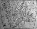
Livio Sanuto's plan to describe and map all continents and thus create a world atlas could only be carried out by him to a small extent. When he died in 1576, Africa was only so self-contained that Giulio Sanuto, his brother, was able to finish all the cards and publish the work in 1588. The atlas ( Geografia dell 'Africa ) contained 12 maps (copperplate engravings) and was provided with extensive comments. In total, it comprised 146 pages and was kept in the same practical format as the publisher and map dealer Antonio Lafreri (1512–1577) had first used in his publications. The precision of the Sanutoic maps (despite all the inaccuracies and errors of the time) is still impressive after centuries and it is a pity that Livio Sanuto was not allowed to create a complete world atlas, which was certainly an outstanding work in the history of cartography would.
The title page and some map images from the atlas:

Front page

TABULA I

TABULA V
TABULA X

TABULA XI


Globes
- Of the earth globes that Livio Sanuto made together with Giulio, one piece has survived: the so-called Holzheim globe , which dates from 1561 and measures 68.5 cm in diameter.
- Another terrestrial globe, stored in a square wooden frame, is also attributed to him.
literature
- Livio Sanuto: Geografia di M. Livio Sanuto distinta i XII libri: Ne 'quali, oltra I' esplicatone di molti luoghi di Tolemeo, e dalla Bussola, e dell 'Aguglia, si dichiarano le prouincie, popoli, regni, città, porti, monti, fiumi, laghi, e costumi dell 'Africa: con XII tanole di essa Africa in dissegno di rame: aggiuntini di pin tre indici da M. Giovan Carlo Saraceni , Damiano Zenaro, Venice 1588 (new edition: Amsterdam 1965) ( digitalisat )
- Georges Grosjean : History of Cartography , Publishing House of the Geographical Institute of the University of Bern, Bern 1996, ISBN 3-906151-15-8
Web links
- Bayerische Staatsbibliothek Geografia dell 'Africa in the first edition from 1588
- Culturegraph ( Memento of March 15, 2014 in the Internet Archive ) Information about Livio Sanuto
- Literature by and about Livio Sanuto in the bibliographic database WorldCat
Individual evidence
- ↑ Globoo terrestre , accessed July 19, 2014
| personal data | |
|---|---|
| SURNAME | Sanuto, Livio |
| ALTERNATIVE NAMES | Sanudo, Livio; Sanutus, Livy |
| BRIEF DESCRIPTION | Italian cosmographer and mathematician |
| DATE OF BIRTH | around 1520 |
| PLACE OF BIRTH | unsure: Venice |
| DATE OF DEATH | 1576 |
| Place of death | Italy |