Loch Ericht
| Loch Ericht | ||
|---|---|---|

|
||
| Geographical location | Grampian Mountains , Scotland | |
| Tributaries | Alder Burn, Cam Chriochan | |
| Drain | Ericht → Loch Rannoch → Tummel → Tay → Firth of Tay → North Sea | |
| Places on the shore | Dalwhinnie | |
| Data | ||
| Coordinates | 56 ° 51 ′ N , 4 ° 21 ′ W | |
|
|
||
| Altitude above sea level | 351 m ASL | |
| surface | 19 km² | |
| length | 23 km | |
| width | 1 km | |
| volume | 1.08 km³ | |
| Maximum depth | 156 m | |
| Middle deep | 58 m | |
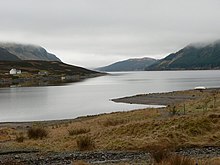
Loch Ericht ( Scottish Gaelic : Loch Eireachd ) is a dammed freshwater lake in the Grampian Mountains on the border of the Scottish Council Areas Highland and Perth and Kinross . The lake lies at an altitude of 351 m and has the typical elongated shape of a lake created by glaciers in the Ice Age . It is about 23 km long, but less than a kilometer wide. The water volume covers approximately 1.08 km³. The greatest depth of the lake is 156 m; the average depth is 58 m. Measured by the size of the water surface of around 19 km², Loch Ericht is the eighth largest lake in Scotland.
Loch Ericht is used to generate electrical energy and is bounded by a dam at both the southwest end and the northeast. From the south-western dam, water is directed over the river Ericht to a hydropower plant located about six kilometers further south at Bridge of Ericht on the north bank of Loch Rannoch . From there the water continues to flow into Loch Rannoch. The dam to the northeast protects Dalwhinnie from flooding.
Loch Ericht is popular with both anglers and hikers. The anglers come mainly because of the numerous trout in the lake. Hikers appreciate the picturesque landscape. The lake is surrounded by several mountains over 1000 m high, such as Ben Alder (1148 m) and Geal Charn (1132 m). Loch Ericht is relatively easy to reach in the northeast via the A889 . Dalwhinnie train station is also just 500 m from the northeast dam. Many other bank sections, however, are not accessible by roads.

