Loenen (Apeldoorn)
 flag |
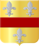
 coat of arms |
| province |
|
| local community |
|
|
Area - land - water |
36.91 km 2 36.86 km 2 0.05 km 2 |
| Residents | 3,130 (Jan. 1, 2017) |
| Coordinates | 52 ° 7 ' N , 6 ° 1' E |
| Important traffic route |
|
| prefix | 055 |
| Postcodes | 6953, 6961, 7351, 7361, 7364, 7371, 7381-7382 |
| Website | Homepage of Loenen |
| Location of Loenen in the municipality of Apeldoorn | |
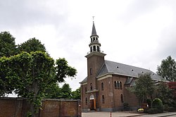
| Roman Catholic Church | |
Loenen ( Low German Loen ) is a village in the Dutch municipality of Apeldoorn in the province of Gelderland .
Loenen consists of two parts that were known in the past, verifiably since the year 838, under the names Lona and Sulvalda, today's district of Zilven. Loenen was an independent municipality until 1818.
In Loenen there is the Ereveld Loenen Cemetery of Honor , where around 4,000 victims of the Second World War are buried.
Web links
Commons : Loenen - collection of images, videos and audio files
- Place website (Dutch)
Individual evidence
- ↑ Kerncijfers wijken en buurten 2017 Centraal Bureau voor de Statistiek , accessed on July 1, 2018 (Dutch)

