Deweerth garden
| This article was entered in the Wuppertal project for improvement. Help edit it and take part in the discussion ! |
The following improvements would be good: ambiguous and incorrectly detailed connections
The Deweerth'sche Garten , together with the Luisenpark, is a more than 200 year old 1.8 hectare inner-city park in the Elberfeld district of Wuppertal .
location
Deweerth'sche Garten is located at the beginning of Briller Straße and at the end of Luisenstraße , and thus at the foot of Nützenberg in the immediate vicinity of Robert-Daum-Platz and the Briller district .
In a northerly direction, on the slope opposite the garden on the other side of Luisenstrasse, there is an approximately 8600 m² grove, the Luisenpark , through which the Ölberg district can be reached via a staircase .
To the east of Deweerth'sche garden is bordered by houses, directly on the as Sophienkirche known Reformed New Church lie. Next to it is the Villa Schmits , the 1000th protected monument in Wuppertal, which today houses the Herder School .
To the south, the garden is separated from Friedrich-Ebert-Strasse by residential and commercial buildings with numerous medical practices (“health center”). On the ground floor of the commercial buildings, catering establishments also operate outdoor gardens.
To the west, on Briller Strasse , is Villa Frowein , built in 1870/71 , the former home of Elberfeld textile entrepreneur Rudolf Frowein and his wife Elisabeth from the De Weerth family .
The memorial for the victims of National Socialism and a modern fountain, a so-called water sculpture by the sculptor Carlernst Kürten, are located on the approximately 8,000 m² garden area . There is also the opportunity to play boules or table tennis , and there is a playground for children .
history

The park was laid out in 1802 as a pleasure garden on the Brill by the Elector Palatine Commerce Councilor Peter de Weerth . The Luisenpark and the Deweerth'sche Garten were originally a contiguous park, which was only separated into two parts later in the 19th century by the Luisenstrasse.
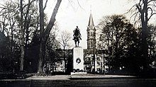
From 1937, the equestrian statue of the Kaiser Wilhelm Memorial for Wilhelm I was erected in the park , which had been moved here from Brausenwerther Platz . The statue was dismantled in 1943 and melted down for war use. The park was renewed in the post-war period . The base of the imperial monument was preserved and has been carrying the memorial for the victims of National Socialism since 1958 .
The eastern part of the original park area now belongs to the adjacent Herder School.
Archaeological site
In 2003, an existing underground car park under the commercial buildings in the south of the square was expanded by 100 more spaces under the garden. To this end, extensive earthworks were carried out in the park. During this work, fragments of ceramic were discovered on a 2 m × 3 m area, which date back to the Latène period between 600 and 400 BC. Dated. After the construction work was completed, the garden was almost restored to its original state.
literature
- Jörg Scheidt: An Iron Age settlement at Deweerth's garden and a bronze ax from Oberbarmen. Archaeological examination of metal age finds from Wuppertal. Romerike Berge 1/2017, pp. 28–36
Web links
- medical-center.de , The Deweerthsche Garden
- Elberfeld district ( Memento from December 5, 2012 in the web archive archive.today ) by Wolfgang Mondorf
Individual evidence
- ↑ It's green so green ... ( Memento from November 27, 2004 in the web archive archive.today ), in: Wuppertaler Rundschau , November 17, 2004.
- ↑ 51 ° 15 '18 " N , 7 ° 7' 58" E
- ↑ Entry in the list of monuments in Wuppertal ( Memento from February 12, 2013 in the web archive archive.today )
- ↑ Jan Niko Kirschbaum: Kaiser Wilhelm Monument. In: denkmal-wuppertal.de.
- ↑ Development plan 912 - Robert-Daum-Platz / Friedrich-Ebert-Straße , Wuppertal.de, accessed July 2008
- ↑ CDU parliamentary group on site: Deweerthscher Garten August 4th 2003 Christian Democratic Union Wuppertal
- ↑ Jörg Scheidt: An Iron Age settlement at Deweerth's garden and a bronze ax from Oberbarmen. Archaeological examination of metal age finds from Wuppertal. Romerike Berge 1/2017, p. 28ff
Coordinates: 51 ° 15 ′ 15 ″ N , 7 ° 8 ′ 0 ″ E


