Lynch Island
| Lynch Island | ||
|---|---|---|
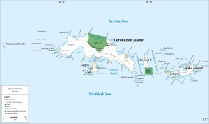
| Map of the southern Orkney Islands with Lynch Island north of Signy Island (center) | ||
| Waters | Marshall Bay ( Coronation Island ) | |
| Archipelago | South Orkney Islands | |
| Geographical location | 60 ° 39 ′ 9 ″ S , 45 ° 36 ′ 24 ″ W | |
|
|
||
| length | 500 m | |
| width | 350 m | |
| surface | 10 ha | |
| Highest elevation | 57 m | |
| Residents | uninhabited | |
Lynch Island is a small island in the archipelago of the South Orkney Islands . Because of its extensive lawn of Antarctic Schmiele, it stands as Antarctic Specially Protected Area No. 110 under the special protection of the Antarctic Treaty .
geography
The island is located in the far east of Marshall Bay , about 200 m off the coast of Coronation Island and 1.5 miles north of Signy Island . It is about 500 m long, 350 m wide and has an area of 10 hectares. Lynch Iceland is on three sides of up to 20 m high cliffs surrounding it. In the north, a low cliff, only 5 to 8 meters high, is followed by a rock terrace that rises moderately to a 40 to 50 meter high plateau . The island reaches its greatest height at 57 m near its south coast. The plateau can be reached relatively easily from a beach on the eastern north coast. Some meltwater channels carry water in summer, but there are no year-round streams.
natural reserve
Lynch Iceland was in 1966 on a proposal from Britain as a Specially Protected Area No. 14 placed under protection. Until then, the island was hardly exposed to human influence. A first administrative plan came into force in 1991.
The island's vegetation is particularly worthy of protection . The up to 15 m × 50 m large lawns from Antarctic Schmiele ( Deschampsia antarctica ) represent the largest populations of this species on the southern Orkney Islands and are among the most extensive and densest in the scope of the Antarctic Treaty. The second Antarctic flowering plant , the Antarctic pearlwort ( Colobanthus quitensis ), is also found in large numbers on the island. In addition, especially in the northeast, there are flat, but sometimes extensive carpets of the moss species Chorisodontium aciphyllum and Polytrichum strictum ( stiff-leaved woman's hair ).
There are no colonies of penguins or other birds on Lynch Island . However, individual breeding pairs of the subantarctic skua , the Dominican gull , the Cape petrel , the snow petrel and the spotted petrel have been observed. Since the 1980s, an increasing number of young males of the Antarctic fur seal have been identified on the island , which have already caused severe damage to the moss carpets in the northeast.
history
The Norwegian whaling captain Petter Sørlle roughly mapped the island in the summer of 1912/1913. It got its current name after it was measured by the Falkland Islands Dependencies Survey . It is reminiscent of the American seal hunter Thomas Bowen Lynch (1832–1920), who visited the South Orkney Islands in 1880 on the Schooner Express .
Individual evidence
- ↑ a b c d e Secretariat of the Antarctic Treaty: Lynch Island, South Orkney Islands (PDF; 470 kB), Management Plan for Antarctic Specially Protected Area No. 110, 2012 (English)
- ↑ Lynch Island in the Geographic Names Information System of the United States Geological Survey (English)

