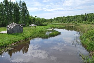
Madajõgi
| Madajõgi | ||
|
The Mädajõgi River meanders through the historic Estonian - Setuese landscapes of Võrumaa and Setumaa |
||
| Data | ||
| location | Estonia | |
| River system | Narva | |
| Drain over | Võhandu → Lake Peipus → Narva → Gulf of Finland | |
| source | See Kovera 57 ° 54 '19 " N , 27 ° 30' 52" O |
|
| Source height | approx. 60 m | |
| muzzle | in the river Võhandu Coordinates: 58 ° 3 ′ 55 ″ N , 27 ° 31 ′ 9 ″ E 58 ° 3 ′ 55 ″ N , 27 ° 31 ′ 9 ″ E |
|
| Mouth height | approx. 30 m | |
| Height difference | approx. 30 m | |
| Bottom slope | approx. 1.1 ‰ | |
| length | 27 km | |
| Catchment area | 246 km² | |
| Left tributaries | Rebasmäe | |
The Mädajõgi is a 27 km long river in the Põlva County in southeast Estonia with a catchment area of 246 km².
The Mädajõgi has its source in Lake Kõvera ( Kõvera järv ). It flows into the Võhandu River , 5.2 km from its mouth in the Peipus Lake ( Peipsi järv ). The Mädajõgi is a right tributary of the Võhandu.
literature
