
Märjelensee
| Märjelenseen | ||
|---|---|---|

|
||
| Aletsch Glacier and one of the permanent Märjelenseen lakes | ||
| Geographical location | on the left, eastern edge of the Aletsch Glacier | |
| Data | ||
| Coordinates | 650 209 / 143 478 | |
|
||
| Altitude above sea level |
2302 m above sea level M. reservoir: 2360 m above sea level M. |
|
| surface | 0.32 ha | |
| Maximum depth | 45 m | |
|
particularities |
Ice reservoir created in the 19th century |
|

The Märjelensee , today: The Märjelenseen are a lake system in the Swiss canton of Valais on the eastern edge of the Aletsch Glacier in the Bernese Alps from an altitude of 2302 m above sea level. M. The various small lakes are situated in a valley between the Eggishorn ( 2927 m above sea level. M. ) and the Strahlhorn ( 3026.5 m above sea level. M. ).
history

In the 19th century, when the Aletsch Glacier rises, what was then Märjelensee was naturally dammed into an ice reservoir (or: “Glacier Edge Lake”) and was up to 1.6 kilometers long and 500 meters wide. Today the lake (barely 100 meters long and about 60 meters lower) is sometimes called "Hintersee", which forms on the edge of the ice.
The eruptions of the then large lake caused by the sudden drainage of the dammed water through crevasses in the glacier repeatedly caused severe flooding below the Aletsch glacier in the valley of the Massa .
Glacier reports record eruptions at the following times: August 1813, July 1820, July 1822, July 1828, autumn 1840, August 1848, 1858, 1859, July 1864, 1871, 1872, 1873, 1874, 1875, 1876, July 19, 1878, 9 ./10. June 1882, January 1883, August 1884, September 4, 1887, June 24, 1889, July 25, 1890, 1892, 1894, September 24, 1895.
In addition to these eruptions, there were also damaging floods in the white water in the Fieschertal in the 19th century .
In order to prevent further damage from ice reservoir eruptions, first a small, then a larger canal was built in the direction of Fieschertal in 1828 and 1829 . The trenches failed or had possibly been filled in by the Fieschers , as they were not interested in additional water in their valley. In the summer of 1895, a relief tunnel over 500 meters long was created, with which the maximum congestion rate could be limited. Due to the glacier retreat in the 20th century , this relief tunnel was only in operation once in 1896.
In 1908, the state hydrology of Switzerland initiated a thorough investigation of the level fluctuations in the lake. The result was a comprehensive study that Otto Lütschg published in book form in 1915.
In order to record the changes in the water level precisely, hydrologists set up a level system. They placed cast-iron, scaled level plates individually or in steps in groups in the smoothly ground ledges on the lake shore at the time. Today these yardsticks are visible high up on the left slope of the valley, on the way from the glacier to the «Gletscherstube» mountain hut.
With a few exceptions, the now much smaller Märjelensee has been running out every year since 1901. The Staukote is now a good 60 meters below the old relief tunnel. Since the Gibidum reservoir was also created, the Massa floods can no longer flood the Rhone valley .
In the 1980s, the highest basin in the former lake area was dammed up to supply the municipality of Bettmeralp with water . The project was a national political issue for nature conservation reasons. The lake formerly located there with a lake level at 2348 m above sea level. M. was at 2360 m above sea level. M. pent up. The accommodation created at the time of construction is today's Gletscherstube mountain hut . The Tälligrattunnel (NW entrance at 2347 m above sea level ), which was created for the construction of the Märjelen reservoir, also known as the "front lake ", can now be used as a hiking trail.
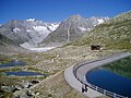
Märjelen reservoir (front lake), other lakes and the Gletscherstube mountain hut

A smaller lake in the Märjela area in July 2007, morning mood
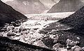
The rear Märjelensee in September 1887 after being emptied
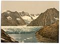
Postcard from the period 1890 to 1900


,_Valais,_Alps_of,_Switzerland-LCCN2001703305.jpg)
Web links
- Gletscherstube at Märjelensee on the Great Aletsch Glacier
Individual evidence
- ↑ a b Märjelenseen on SwissTopo (maps of Switzerland)
- ↑ a b Märjelen reservoir on SwissTopo (maps of Switzerland)
- ↑ Gallery outflow Märjelensee Management Center World Heritage
- ↑ Otto Lütschg: The Märjelensee and its flow conditions: a hydrological study taking into account hydrographic phenomena in other river areas , Volume 1 of Annalen der Schweiz. State Hydrography, Federal Department of the Interior, publisher: Buchdruck A. Kündig, 1915
- ↑ When boats were still circling the icebergs at 2300 meters , Walliser Bote, July 24, 2017, page 6, published on the homepage of the municipality of Fiesch, accessed on November 22, 2017 (link opens PDF)