Mill Lake (Kargow)
| Mill Lake | ||
|---|---|---|

|
||
| Mill Lake | ||
| Geographical location | District of Mecklenburg Lake District , Mecklenburg-Western Pomerania | |
| Tributaries | Digging a lake to the north | |
| Drain | through a fen to the Nietingsee | |
| Data | ||
| Coordinates | 53 ° 27 '4 " N , 12 ° 49' 28" E | |
|
|
||
| Altitude above sea level | 65 m above sea level NHN | |
| surface | 20.7 ha | |
| length | 1.00 km | |
| width | 0.33 km | |
The Mühlensee is a lake in the area of the municipality Kargow in the Mecklenburg Lake District in Mecklenburg-Western Pomerania . It is located in the middle of the Müritz National Park about one and a half kilometers northwest of the Kargower district of Speck. Its name is derived from a water mill that stood on its west bank 200 years ago.
Mill channel
The Mühlensee is the namesake of an Ice Age channel on the southern edge of the terminal moraine , which runs across the Müritz National Park. The channel is about three kilometers long and begins at a small, nameless lake. From there it runs to the south, where it is taken in full width by the Mühlensee. After a change of direction to the east, the much smaller Nietingsee follows , behind which it turns to the southeast and at Speck meets the Rieselwiese at right angles, where it ends and its water leads over a ditch to the Hofsee .
Close to the lake were in the Mühlenseerinne fens , leaked by the excess water in low-lying areas. The difference in height to the Specker See , which is only separated by a narrow terminal moraine section, made it possible to build a watermill on the Mühlensee by building a mill ditch. This was kept open to drain the area even after the mill had stopped operating, so that the water level in the mill lake channel continued to sink. Parts of the moors and lakes silted up, the adjacent forest areas expanded.
Todays situation
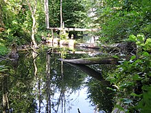
The Mühlensee has been in the Müritz National Park since October 1st, 1990. The national park plan envisaged rewetting the Mühlenseerinne by closing the Mühlengraben in 1993. Since then, the water level has risen by around one meter, the moors have regenerated and the lake areas have expanded. The forest that had advanced up to that point died, and tree stumps have been standing in the lake, which was again larger.
Today the Mühlensee consists of an oval main basin, to which a much smaller, also oval side basin connects to the north, from which water is supplied. It has a size of about 20.7 hectares with a water level at 65 m above sea level. NHN . In a north-west-south-east direction, the lake extends around one kilometer with a maximum width of 330 meters. Due to the transition to the moorland, an exact delimitation of the lake is not possible.
With the exception of its northern end and the fens side in the southeast, it is completely surrounded by forest. On the south-west bank, a circular hiking trail of the national park from Speck runs along the bank. The road from Kargow to Speck, where the mill was located, runs just behind it.
See also
Panorama picture
Individual evidence
- ↑ Müritz National Park Plan , page 129 ( Memento of the original from June 2, 2016 in the Internet Archive ) Info: The archive link was inserted automatically and has not yet been checked. Please check the original and archive link according to the instructions and then remove this notice. (PDF; 575 kB)


