Mühlgraben (Aubach)
|
Mühlgraben Dorfbach |
||
|
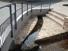
The Mühlgraben in Habichsthal |
||
| Data | ||
| location |
Spessart
|
|
| River system | Rhine | |
| Drain over | Aubach → Lohr → Main → Rhine → North Sea | |
| source | in Habichsthal 50 ° 3 ′ 37 ″ N , 9 ° 24 ′ 5 ″ E |
|
| Source height | 318 m above sea level NHN | |
| muzzle | east of Habichstal in the Aubach Coordinates: 50 ° 3 '40 " N , 9 ° 24' 47" E 50 ° 3 '40 " N , 9 ° 24' 47" E |
|
| Mouth height | 283 m above sea level NHN | |
| Height difference | 35 m | |
| Bottom slope | 37 ‰ | |
| length | 940 m | |
| Catchment area | approx. 6 km² | |
|
The Mühlgraben (behind) flows into the Aubach |
||
The Mühlgraben, also called Mühlbach or Dorfbach , is a right tributary of the Aubach in the Main-Spessart district in the Bavarian Spessart .
geography
course
The Mühlgraben has its source in several sources in Habichsthal .
It runs to the east through a walled channel . To the east of the village it flows out at an altitude of 283 m above sea level. NHN above the Aubachseen from the right into the Aubach.
On its 0.9 km long path, the ditch overcomes a height difference of about 35 m, which corresponds to a mean bed gradient of 37 ‰. The Mühlgraben drains a catchment area of around 6 km across the Aubach, Lohr , Main and Rhine to the North Sea .
Lohr river system
history
In the past, the Mühlgraben at its mouth fed the Habichsthaler Dorfmühle. The communal mill was allowed to be used by every citizen on his own meal day. If there was not enough headwater, more water was fed to the mill wheel through a wooden canal. This rises in the middle of the slope up the valley on the Aubach.
A part of the Mühlgrabenwasser was directed at the lower reaches into an artificial irrigation ditch , the Schwedels- or Schwedlesgab, which ended in the Schwedlesrain corridor .
See also
Web links
- The Mühlgraben on the BayernAtlas


