Madereck
| Madereck | ||
|---|---|---|
|
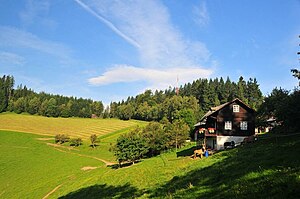
Madereck summit meadow and Almgasthaus Puster |
||
| height | 1050 m above sea level A. | |
| location | Styria , Austria | |
| Mountains | Hochschwab group | |
| Dominance | 3.4 km → Kletschachkogel | |
| Notch height | 320 m ↓ climb | |
| Coordinates | 47 ° 25 '11 " N , 15 ° 13' 19" E | |
|
|
||
| rock | Spilite , diabase , green slate , phyllite | |
The Madereck is a 1050 m above sea level. A. high mountain in the northwest of Bruck an der Mur . Along with the Brucker Hochanger and the Rennfeld , the Madereck is one of the local mountains of Bruck an der Mur. It is a southern branch of the Hochschwab group and belongs to the Grauwackenzone .
geography
The mountain is largely forested and only in the summit area is characterized by a mountain meadow landscape.
Ascent
The ascent is mostly from the city center of Bruck over the Krecker to the summit. The path from the Paulahofsiedlung to the summit is also popular.
tourism
It is a popular hiking and mountain bike destination, especially for the local population. The Almgasthaus Puster is located directly below the summit.


