Makeness Kipps
| Makeness Kipps | ||
|---|---|---|
|
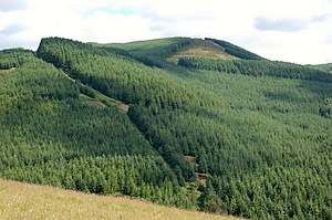
The two peaks of the Makeness Kipps |
||
| height | 587 m ASL | |
| location | Scottish Borders , Scotland | |
| Mountains | Moorfoot Hills | |
| Notch height | 57 m | |
| Coordinates | 55 ° 41 '6 " N , 3 ° 8' 38" W | |
|
|
||
The Makeness Kipps , also Shieldgreen Kipps , are a hill with two adjacent knolls in the Moorfoot Hills . It is located near the western edge of the range of hills. Its 587 and 583 m high peaks are in the Scottish Council Area Scottish Borders . Another 563 m high knoll lies north.
The Makeness Kipps rise about five kilometers northeast of Peebles and southeast of Eddleston . Its slopes are largely forested as part of the Glentress Forests . The height of the Makeness Kipps is 57 meters.
Surroundings
The upper reaches of the Soonhope Burn , which rises at neighboring Cardon Law, runs along its western flank . To the southeast border the Dunslair Heights ; northeast of Totto Hill .
On the southern flank of the Makeness Kipps are the ruins of Shieldgreen Tower . The Stoddart family had the Tower House reached in the 16th century. In the middle of the following century it passed to the Earl of Tweeddale . The ruins are listed as a Scheduled Monument . The well to supply the Tower House is said to have been to the northeast. After it was described in the middle of the 19th century, the fountain could not be found on an inspection around 100 years later.
Individual evidence
- ↑ a b entry on themountainguide.co.uk .
- ↑ a b Entry in the Gazetteer for Scotland
- ^ Map of the Ordnance Survey
- ↑ Entry on Shieldgreen Tower in Canmore, the database of Historic Environment Scotland (English)
- ↑ Scheduled Monument - Entry . In: Historic Scotland .
- ↑ Entry on Tower Well in Canmore, the database of Historic Environment Scotland (English)

