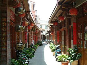
Magong
|
Magong 馬 公 市 |
||
 Street in the old town of Magong |
||
|
||
| State : |
|
|
| County : | Penghu | |
| Coordinates : | 23 ° 34 ' N , 119 ° 35' E | |
| Height : | 12 m | |
| Area : | 33.9918 km² | |
| Residents : | 62,185 (June 2018) | |
| Population density : | 1,829 inhabitants per km² | |
| Time zone : | UTC + 8 (Chungyuan time) | |
| Telephone code : | (+886) (0) 6 | |
| Postal code : | 880 | |
| ISO 3166-2 : | TW-PEN | |
| Community type : | City ( 市 , Shì ) | |
| Structure : | 34 districts ( 里 , Lǐ ) | |
| Mayor : | Ye Zhulin ( Chinese 葉竹林 ) ( KMT ) | |
| Website : | ||
|
|
||
The city of Magong or Makung ( Chinese 馬 公 市 / 马 公 市 , Pinyin Mǎgōng Shì , Tongyong Pinyin Mǎgong Shìh , W.-G. Ma-kung Shih , Pe̍h-ōe-jī Má-keng-chhī ) is the capital of the Republic of China Penghu Islands (Pescadors) belonging to Taiwan . It had around 62,000 inhabitants in 2018 and is home to well over half of the population of the archipelago, which is about 60 km off the west coast of Taiwan on the Formosa Strait .
history
The Tianhou Temple in Magong is the oldest Mazu Temple in Taiwan. The original place name was actually 媽 宮 / 妈 宫 , Māgōng - "Mazu palace", ( 媽 / 妈 , mā - "mother"), but in 1921 during the Japanese rule it became today's, similarly-sounding 馬 公 / 马 公 , Mǎgōng - "Prince Ma" changed ( 馬 / 马 , mǎ - "horse"). After the transfer of Taiwan to the Republic of China in 1945, the place received the status of a township ( 鎮 / 镇 , Zhèn ) and on December 25, 1981 the status of a city ( 市 , Shì ).
Magong has a domestic airport .
administration
The city of Magong is divided into 33 districts ( 里 , Lǐ - "small village, settlement"):
- Anshan ( 案 山里 )
- Anzhe ( 安 宅 里 )
- Caiyuan ( 菜園 里 )
- Chang'an ( 長安 里 )
- Chaoyang ( 朝陽 里 )
- Chongguang ( 重 光 里 )
- Chongqing ( 重慶 里 )
- Dongwei ( 東 衛 里 )
- Dongwen ( 東 文 里 )
- Fenggui ( 風 櫃里 )
- Fujing ( 虎井 里 )
- Fuxing ( 復興 里 )
- Guangfu ( 光復 里 )
- Guanghua ( 光華 里 )
- Guangming ( 光明 里 )
- Guangrong ( 光榮 里 )
- Jing'an ( 井 垵 里 )
- Qianliao ( 前 寮 里 )
- Qiming ( 啟明 里 )
- Shanshui ( 山水 里 )
- Shili ( 嵵 裡 里 )
- Shiquan ( 石泉 里 )
- Suogang ( 鎖 港 里 )
- Tiexian ( 鐵線 里 )
- Tongpan ( 桶 盤 里 )
- Wude ( 五 德里 )
- Wukan ( 烏 崁 里 )
- Xingren ( 興仁 里 )
- Xiwei ( 西 衛 里 )
- Xiwen ( 西 文 里 )
- Yangming ( 陽明 里 )
- Zhongxing ( 中興 里 )
- Zhongyang ( 中央 里 )
Individual evidence
- ↑ Census "(人口統計)" - Chinese: online - Retrieved on May 12, 2017 - penghu.gov.tw - Online
- ↑ 馬 公 市 小 檔案 ("Brief data on Magong"). Magong website, May 7, 2018, accessed July 21, 2018 (Chinese).
- ↑ Magong administrative change and development: ... 02/01/99 Republic of China (02/01/2011), incorporation of Xinfu (新 復 里, Xinfu li) into the village communities of Fuxing (復興 里, Fuxing li) and Chang'an (長安 里, Chang'an li) from Magong, number of villages reduced by 1, number of administrative villages changed to 33 - "馬 公 行政 沿革: .... 民國 99 年 2 月 1 日 馬 公 市 新 復 里 併入 復興 、 長安 里, 減少 1 里 , 所轄 變更 為 33 里. " - Chinese: online ( Memento of the original from May 4, 2017 in the Internet Archive ) Info: The archive link was automatically inserted and not yet checked. Please check the original and archive link according to the instructions and then remove this notice. - Retrieved May 12, 2017 - mkcity.gov.tw - Online
- ↑ Villages and neighborhoods "(里 鄰 介紹)" - Chinese: online ( Memento of the original from May 3, 2017 in the Internet Archive ) Info: The archive link was automatically inserted and not yet checked. Please check the original and archive link according to the instructions and then remove this notice. - Retrieved May 12, 2017 - mkcity.gov.tw - Online
- ↑ 行政 區域 圖 ("administrative area map"). Magong website, accessed July 21, 2018 (Chinese).


