
Maria-Josepha-Strasse
| Maria-Josepha-Strasse | |
|---|---|
|
|
|
| Basic data | |
| State capital | Munich |
| Borough | Schwabing-Freimann |
| Hist. Names | Meadow road |
| Name received | November 12, 1892 |
| Connecting roads | Dillisstrasse, Mandlstrasse , Koeniginstrasse |
| Cross streets | Kaulbachstrasse , Werneckstrasse |
| Places | Nikolaiplatz |
| Numbering system | Orientation numbering |
| use | |
| User groups | Pedestrian traffic , bicycle traffic , individual traffic |
| Technical specifications | |
| Street length | 260 m |
The Maria-Josepha-Straße is a street in the Munich district of Schwabing . It runs west of the English Garden from Dillisstrasse or Nikolaiplatz to the corner of Mandlstrasse and Königinstrasse and forms the southern edge of the protected Alt-Schwabing building complex . The street is named after Maria Josepha of Portugal , second wife of Duke Carl Theodor in Bavaria . The name change from the street originally called Wiesenstraße took place in the course of the incorporation of Schwabing into Munich in 1891. Countless streets in the old town center of Altschwabing were given new addresses and names. According to Rambaldi, street names were officially assigned as early as 1890, and the name has been recognized since November 12, 1892 for the postal location of the buildings along this street. The street name is not yet found on city maps from 1890 and 1891.
At the beginning of Maria-Josepha-Straße is the Seidlvilla (also "Villa Lautenbacher") built in 1905 by Emanuel von Seidl in the German Renaissance style with Art Nouveau forms . The fishing fountain designed by Eugen Mayer-Fassold between 1928 and 1929 is located on Nikolaiplatz.
At the corner of Kaulbach- and Maria-Josepha-Straße is a former publishing house of the Bavarian telephone book publisher from the 1950s, which is to be replaced by a house with 28 apartments as well as offices and practices. There is also a Munich Re office building completed in March 2013 , the construction of which was very controversial.
Until the 1960s, tram line 22 ran to Schwabing and turned in a loop at Nikolaiplatz. In the curve between Maria-Josepha-Straße and Nikolaiplatz, the tram tracks are still visible through holes in the pavement and hollows in the asphalt. From here, tracks had already been laid for a possible connection through the English Garden.
The count in the mail address Nikolaiplatz 1b lying also on the Maria-Josepha-Straße Seidlvilla and the fishing wells are located at only 260 m long road nine listed buildings , also the street belongs to the ensemble protection Altschwabing (E-1-62-000-4 ).
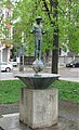
1928–1929 Eugen Mayer-Fassold built a fishing fountain

Biedermeier- late classicist house from the 2nd quarter of the 19th century, from 1882 to 1918 the house of the painter Franz Xaver Simm in Maria-Josepha-Str. 5

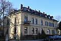
Villa Loeb built by Carl Sattler in the style of a north German baroque mansion in raw brick with clay reliefs from 1909 for the art collector James Loeb , now Bayerischer Adreßbuchverlag. The property had been in the possession of Adolf Furtwängler since 1895 , and Elisabet Ney's villa was built on until his death in 1907, and until 1899 it had the address "An der Grube 8".

Hipped roof house built around 1800 at Maria-Josepha-Straße 10

Neoclassical, factual raw brick villa from the beginning of the 20th century in Maria-Josepha-Str. 12
Villa-like semi-detached house in neo-renaissance style 1886 at Maria-Josepha-Straße 14-16

In 1906/07 Friedrich von Thiersch built a hip roof villa in Art Nouveau style at Mandlstrasse 1, in front of which there is a fountain designed in 1907 by Mathias Gasteiger with two Art Nouveau herms

.jpg)


Individual evidence
- ↑ Stefan Mühleisen: Ausgebremst In: Süddeutsche Zeitung December 11, 2015
- ^ Max Gorbach: Vom Leprosenhaus zum Schwabinger Bach , Homa, Munich 1979
- ↑ Theodor Dombart: Schwabing - letter chats , Bayerland, Munich 1913
- ^ Karl Graf von Rambaldi: The Munich street names and their explanation Munich: Piloty & Loehle, 1894. OCLC 252718711
- ^ Alfred Dürr: Sensible Lage In: Süddeutsche Zeitung April 15, 2016
- ↑ http://www.lumen-pm.de/pdf/lumen_gmbh_maria_joseph_strasse.pdf
- ↑ Valentina Horchvv: Altschwabing: A "building block" excites the minds In: Münchner Merkur June 13, 2009
- ↑ Almut Ringleben: Relics of a Tram Line In: Abendzeitung June 24, 2013
- ^ Kristian Bäthe: Who lived where in Schwabing , Süddeutscher Verlag Munich 1965. P. 272
Coordinates: 48 ° 9 ′ 29.2 ″ N , 11 ° 35 ′ 17 ″ E