
Market fortification Schottwien
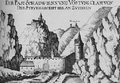
View of the upper barrier wall with the castles Klamm and Wartenstein , in front of the wall (left) stood the citizen hospital, copper engraving, Georg Matthäus Vischer , around 1672

Ruins of the eastern defense tower at the upper fortification
Schottwiener Ortsstraße and the upper wall of the fortifications towards the Semmering Pass around 1830

Cavern in the rock face at the upper fortification

View of the lower barrier wall, the castle of Klamm, the Schusterloch (below the castle) and the two powder towers on the fairground, copper engraving, Georg Matthäus Vischer, around 1672

The remains of the lower barrier wall as seen from the little town

Ruins of the upper powder tower on the little street

Ruins of the lower powder tower on the little town


The market fortification Schottwien is located in the market town of Schottwien in the Neunkirchen district , Lower Austria , Austria .
history
In 1254 the Bohemian King Ottokar II. Přemysl was awarded the Duchy of Austria and the Mark Pitten in the Peace of Oven . To protect against attacks from the Duchy of Styria , Ottokar also had Schottwien fortified. Construction of the first fortifications began in the 13th century. Using the topographical conditions, the market fortification - first mentioned in a document in 1349 - formed two dams above and below the town, the remains of which are still preserved today, mostly from the 16th century.
description
Wall remains from the end of the 15th century have been preserved. The castle ruin Klamm - probably from the second half of the 13th century or around 1400 - stands at the northern end of the village on a mountain ridge leading down from Eselstein . Two more defensive structures, square in plan, consisting of quarry stone masonry with corner squaring, have been preserved at a height of a few meters. These are the two so-called “powder towers” that stood on a 30 m high rocky ridge of the Eselstein (“Turndlein” or “Tändlein”) between Semmeringstrasse and Haidbachgraben. They were originally used as defensive towers, later as weapons and ammunition stores and finally as prisons.
Taking advantage of the topographical conditions and thereby including two half caves, there is a lower and an upper dam. At the northern exit of the village there is mixed masonry with a battlement and loopholes. At the southern exit of the village there is a double wall made of quarry stone with a battlement crowned battlements and a round tower with key notches.
- Upper wall
47 ° 39 ′ 12 ″ N, 15 ° 52 ′ 14 ″ E
It was supposed to protect the market place against incursions from the Semmering Pass and was particularly well fortified. The barrage consisted of a double wall with two covered passages for rifle shooters, a gate, a defensive tower in the east, an observation point carved into the rock and a passage for the Weißenbach. The defense tower behind the fire station, incorrectly called the “powder tower”, is now used as a viewing point and wasrepairedin2009 byRenate Kordonas part of a competition. From here you have a good overview of the Upper Market. Kilometers of famous cities around the world are engraved on a board. The stream could bedammedwith aweirso that theglaciscould be flooded quickly in the event of an impending siege. The outer wall was destroyed by a flood on May 25, 1833. In the western, approx. 120 m high rock face, there was acavernwith loopholes that could accommodate up to 40 men. It was also equipped with a wooden hand mill to withstand extended sieges.
- Lower wall
47 ° 39 ′ 32 ″ N, 15 ° 52 ′ 23 ″ E
It was a bit lower, not so solidly constructed and also had no covered battlement. The street gate was reinforced by a round defense tower (on the south side). A stone relief of the Schottwiener coat of arms was placed above the archway. In 1828 the lower market gate and its tower had to be removed to make room for the transport of a steam engine toTrieste. Most of the section to the north of the road collapsed in the flood disaster of 1833. Today only the section between the former south tower and the Probstwald and a small remainder on the rock face to the left of the Haidbach can be seen. The overlying caves in the rock face above the road are also known as the "Turkish holes". In them, the citizens of Scotland used them to hide from attackers and looters during the Turkish Wars. In the 120 m high rock above the lower market chapel there was another fortification reinforced with battlements, the so-called Schusterloch.
literature
- The art monuments of Austria. Dehio Lower Austria south of the Danube 2003 . Schottwien, fortification of the market. P. 2141.