Medina peaks
| Medina peaks | ||
|---|---|---|
| location | Marie-Byrd-Land , West Antarctica (politically: Ross Dependency ) | |
| part of | Queen Maud Mountains in the Transantarctic Mountains | |
|
|
||
| Coordinates | 85 ° 36 ′ S , 155 ° 54 ′ W | |
|
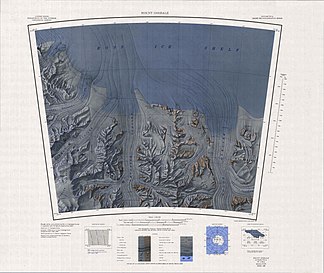
Map from 1966, in the middle of the lower half the Medina Peaks and Hays Mountains |
||
The Medina Peaks are rugged, mainly ice-free mountain peaks on the Amundsen coast in Marie-Byrd Land in western Antarctica . They rise from a mountain range about 25 km long , which extends along the eastern flank of the Goodale Glacier to the north to the southern edge of the Ross Ice Shelf .
Some of these mountains were discovered and roughly mapped during the first Antarctic expedition (1928–1930) by the US polar explorer Richard Evelyn Byrd . The Advisory Committee on Antarctic Names named it in 1967 after Guillermo Medina, Technical Director of the United States Hydrographic Office (1954-1960) and the Naval Oceanographic Office (1960-1964).
Web links
- Medina Peaks in the Geographic Names Information System of the United States Geological Survey (English)
- Medina Peaks on geographic.org (English)

