Melton (Suffolk)
| Melton | ||
|---|---|---|
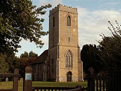
| Andreas Church Melton | ||
| Coordinates | 52 ° 6 ′ N , 1 ° 20 ′ E | |
|
|
||
| Residents | 3741 (as of 2011) | |
| administration | ||
| Post town | WOODBRIDGE | |
| ZIP code section | IP12 | |
| prefix | 01394 | |
| Part of the country | England | |
| region | East of England | |
| Shire county | Suffolk | |
| District | East Suffolk | |
| British Parliament | Suffolk Coastal | |
| Website: http://melton-suffolk-pc.gov.uk/ | ||
Melton is located in Suffolk in the East Suffolk District and is the administrative seat of the district. Melton has about 3700 inhabitants (as of 2011).
geography
Melton is about one mile northeast of Woodbridge on the River Deben . The station is on the East Suffolk Line , the Ipswich – Lowestoft railway.
history
The place was mentioned in the Domesday Book of 1086. The former Loes and Wilford Hundred Incorporation of 1765 was converted into an asylum in 1826. In 1916 it became a hospital (St Audry's Hospital). Today all buildings have been converted into residential buildings.
Sons and daughters of the place
- Searles Valentine Wood (1798–1880), paleontologist, buried here
- Edwin Lankester (1814–1874), physician and naturalist
- David Thomas Ansted (1814-1880), geologist
- Hugh Stowell Scott (1862–1903), novelist (pseudonym: Henry Seton Merriman), died here
Attractions
- Andreaskirche (St Andrew's Church)
- former St Audry's hospital area
Web links
Commons : Melton - collection of images, videos and audio files


