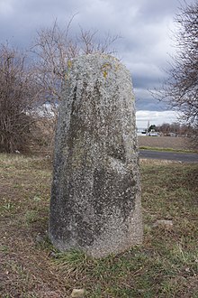
Menhir de la Grande Borne
The Menhir de la Grande Borne (also called Menhir de Sainte Anne, Pierre Longue or Stele von Beaulieu) is a stele from the 2nd century BC. BC, a few dozen meters southeast of the intersection of the D 772 (Rue Élisée-Reclus) and the D 766 (Avenue du Brézet) just a few meters from the roundabout, east of Clermont-Ferrand in the Puy-de-Dôme department in France .
After its overall dimensions were discovered in 2008, the stone is considered to be the most imposing monolith of the Auvergne or the Massif Central . The stone is located in sparse vegetation, about 400 m south of the 2.7 m long, lying Menhir du Puy de la Poix.
It is not to be confused with menhirs with the name Grande Borne z. B. in Chanceaux-près-Loches , in Coulmier-le-Sec , in Genay and in Troyes or the menhir of Beaulieu, in Avrillé .
The slightly rounded menhir made of porphyritic granite comes from the Artière Gorge (near Ceyrat, southwest of Clermont-Ferrand), at a distance of around 9.0 km. The cross-section is cylindrical with four regular surfaces. It has a total length of 5.7 m. Since it is on an embankment, only about 2.5 m are visible. Its weight is estimated at 18 tons. The oval recess on the surface of the southwest side is 21.9 cm long, 13.5 cm wide and 7.0 cm deep. The summit is slightly rounded.
According to Frédéric Surmely, the regular shape suggests that it was edited. After the excavation, he came to the conclusion that the stele was erected during the Latène period and resembles iron age stelae as they are known from western France. The theory of a remodeled Neolithic menhir seems less likely as there are no Neolithic traces nearby.
In addition to the thesis that it is a Neolithic menhir, it was also considered a Roman milestone before 1924 because of the proximity of an ancient path without justification , and in 1924 it was classified as a monument historique under "menhir or milestone" .
The menhir of Puy-de-la-Poix lies just under 400 m to the north-west
See also
literature
- Ulrich Rosenbaum: Auvergne and Massif Central. Cologne 1981, 7th edition 1989. (DuMont art travel guide)
- Jürgen E. Walkowitz: The megalithic syndrome. European cult sites of the Stone Age (= contributions to the prehistory and early history of Central Europe. Vol. 36). Beier & Beran, Langenweißbach 2003, ISBN 3-930036-70-3 .
Web links
- Entry no.PA00092035 in the Base Mérimée of the French Ministry of Culture (French)
- Description (French) and pictures
- Description (English) and pictures
Coordinates: 45 ° 46 ′ 42 " N , 3 ° 8 ′ 54" E
