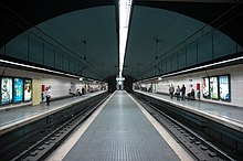
Metro line 6 (Barcelona)
 
|
|||||||||||||||||||||||||||||||||
|---|---|---|---|---|---|---|---|---|---|---|---|---|---|---|---|---|---|---|---|---|---|---|---|---|---|---|---|---|---|---|---|---|---|
|
map
| |||||||||||||||||||||||||||||||||
| Route length: | 5 km | ||||||||||||||||||||||||||||||||
| Gauge : | 1435 mm ( standard gauge ) | ||||||||||||||||||||||||||||||||
|
|||||||||||||||||||||||||||||||||
The L6 is a metro line of the Barcelona Metro .
history
In 1863 the above-ground railway line between Barcelona Plaça Catalunya and Sarrià was opened. Today's Metro de Vallès was moved underground in 1929 and extended to the north. In 1976 an extension was made between Sarrià and the Reina Elisenda station. Due to renovation work at Sarrià station, the L6 was withdrawn there in 2016. The Sarrià – Reina Elisenda section has since been served by the new L12 metro line.
Route description
Line 6 has eight stations, all of which are in the tunnel and - in contrast to the Suburbà lines - stops at all subway stations. The route length is five kilometers. The line runs from the northwestern district of Sarrià-Sant Gervasi to the center of Barcelona at Plaça de Catalunya .
A trip from end point to end point takes about 12 minutes. It is how the lines 7, 8 and 12 of the railway company FGC operated.
Coordinates: 41 ° 23 '9.5 " N , 2 ° 10' 12.4" E

