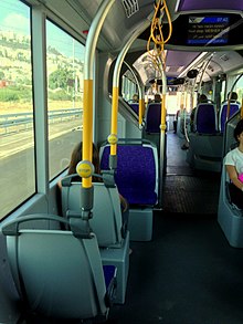
Metronite
Metronite ( Hebrew מטרונית) is a track bus system under construction for the greater Haifa area , Israel . The aim of the project is to serve the city of Haifa on an additional axis with high-quality public transport . In addition, the northern suburbs, called Krajot , which so far have only been served by Israel Railways trains and Egged buses, are opened up. Are used Phileas vehicles of the Dutch VDL .
technology
The Phileas concept that will be used at Metronit differs from conventional track buses. Although dedicated bus lanes are mainly used, the lane guidance is not mechanical, but by inductive lane guidance using magnets embedded in the floor. Although the use of trolleybuses would in principle be possible, hybrid buses were chosen in the Haifa region . Only articulated buses are to be used, including double articulated buses that are completely new to Israel.
concept
The city of Haifa is currently only accessible by conventional buses and the only Karmelit subway line . For inner-city traffic, however, this hardly plays a role. Most of the traffic today takes place along the coast and towards the Krajot. There is a railway line on this route, but due to the low frequency of journeys and the large distance between stops, it is hardly suitable as an urban means of transport for shorter distances.
North of Haifa, in the Krajot, the former suburbs have grown together over the past few decades into a large, contiguous urban area with around 250,000 inhabitants, with no recognizable center and no corresponding transport infrastructure. Kirjat Bialik, for example, with its almost 40,000 inhabitants and several large shopping centers, is not accessible by rail and is only served by conventional buses.
The Metronit network is intended to remedy this structural deficiency in Haifa and the Krajot and to relieve road traffic. The name Metronit was chosen based on the Carmelite.
Line network
The first phase of the project is the establishment of the so-called "heart network", which covers around 20 km. It starts in Bat Galim , where there is a connection to the railway, leads east to Kikar Paris (Pariser Platz), where there is a connection to the Karmelit, on to the central bus station of the Krajot, Merkazit Mifratz , and from there in two branches via Kirjat Bialik to Kirjat Motzkin station or Kirjat Ata.
Final expansion
| Radial lines | route |
|---|---|
| 1 | Krajot West (HaHistadrut-Allee) ↔ Metro Center |
| 2 | Krajot center (Krajot bypass) ↔ Metro center |
| 3 | Krajot East ( Kirjat Ata ) ↔ Metro Center |
| 4th | Nescher ↔ Metro Center |
| 5 | Tirat Carmel and Haifa West ↔ Metro Center |
| Cross lines | route |
| 1 | Krajot-Nord-Kreis: Kirjat Motzkin ↔ Kirjat Bialik |
| 2 | Krajot Center: Kirjat Jam ↔ Kiryat Ata |
| 3 | Krajot South: Kirjat Chaim ↔ Kirjat Ata |
Individual evidence
- ↑ Yefe Nof: Map of the heart ( Memento of the original from December 16, 2008 in the Internet Archive ) Info: The archive link was inserted automatically and has not yet been checked. Please check the original and archive link according to the instructions and then remove this notice. , January 14, 2008


