Mettupalayam
| Mettupalayam மேட்டுப்பாளையம் |
||
|---|---|---|
|
|
||
| State : |
|
|
| State : | Tamil Nadu | |
| District : | Coimbatore | |
| Sub-district : | Mettupalayam | |
| Location : | 11 ° 18 ′ N , 76 ° 57 ′ E | |
| Height : | 305 m | |
| Residents : | 69,213 (2011) | |
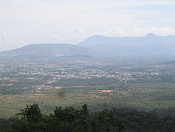
| View of Mettupalayam | ||
Mettupalayam ( Tamil : மேட்டுப்பாளையம் Meṭṭuppāḷaiyam [ ˈmeːʈːɯpːaːɭaijʌm ]) is a city in the southern Indian state of Tamil Nadu . It is located in the Coimbatore district at the foot of the Nilgiri Mountains . The city is 305 meters above sea level and the Bhavani River flows through it. The next larger city is Coimbatore approx. 50 kilometers south. According to the 2011 Indian census, Mettupalayam has around 69,000 inhabitants.
The main traffic connections to the Nilgiri Mountains are via Mettupalayam. Mettupalayam station is the end point of a broad-gauge line from Coimbatore and the beginning of the Nilgiri Mountain Railway , which leads to Udagamandalam and overcomes an altitude difference of over 2000 meters over a distance of 46 kilometers.
69 percent of the population of Mettupalayam are Hindus . There is also a larger minority of Muslims (26 percent) and a smaller Christian minority (5 percent). As in all of Tamil Nadu, the main language is Tamil, which is spoken by 75 percent of the population as their mother tongue. 12 percent speak Telugu , 8 percent Kannada , 4 percent Malayalam, and 1 percent Urdu .
Web links
Individual evidence
- ^ Census of India 2011.
- ^ Census of India 2011: C-1 Population By Religious Community. Tamil Nadu.
- ↑ Census of India 2001: C-16 City: Population by Mother Tongue (Tamil Nadu), accessed under Tabulations Plan of Census Year - 2001 .


