Michelwinnaden
|
Michelwinnaden
City of Bad Waldsee
|
|
|---|---|
| Coordinates: 47 ° 58 '8 " N , 9 ° 43' 44" E | |
| Height : | 579 m above sea level NHN |
| Area : | 11 km² |
| Residents : | 618 (Sep 6, 2007) |
| Population density : | 56 inhabitants / km² |
| Incorporation : | 1st January 1975 |
| Postal code : | 88339 |
| Area code : | 07524 |
|
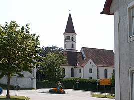
Church in Michelwinnaden
|
|
Michelwinnaden is a district of the town of Bad Waldsee in the Ravensburg district in Baden-Württemberg . Michelwinnaden also includes the residential areas Aspen, Lenatweiler, Lippertsweiler and Michelberg.
history
Michelwinnaden was founded in the 9th century. Displaced alpine slaves were responsible for this . The name 'Winnaden' is derived from this, 'Michel' (large) was added because there is a second place, founded by Winden, which is now called Kleinwinnaden and belongs to the Bad Schussenried district. Nowadays, Michelwinnaden is mostly only referred to as MiWi in the area. On January 1, 1975, Michelwinnaden became a district of the city of Bad Waldsee .
Crack origin
About half a kilometer south of Michelwinnaden, in the Tannwald, one of the two source streams the Riss rises . The so-called cold rift is longer than the second arm, the warm rift , which arises from the nearby Winterstettendorf . The cold crack runs from its origin north to Michelwinnaden. There it flows on the edge of the community through the castle pond.
leisure
Sports
The football club SC MiWi eV was founded in 1977. The Sport Fischereiverein Michelwinnaden e. V. was founded in 1981.
music
The music association >> Concordia << Michelwinnaden eV has existed for over 100 years and was therefore awarded the Pro-Musica badge in May 2014 .
Moat Festival
Every year in summer the traditional moat festival takes place at the castle pond.
Web links
Individual evidence
- ↑ cf. Wiktionary: Michel
- ^ Federal Statistical Office (ed.): Historical municipality directory for the Federal Republic of Germany. Name, border and key number changes in municipalities, counties and administrative districts from May 27, 1970 to December 31, 1982 . W. Kohlhammer, Stuttgart / Mainz 1983, ISBN 3-17-003263-1 , p. 547 .

