
Minami-ku (Kyoto)
|
Municipality of Kyoto |
|
|---|---|
  |
|
| Coordinates | 34 ° 58 '36 " N , 135 ° 44' 47" E |
| surface | 15.78 km² |
| Residents | 101,192 (Oct 1, 2019) |
| Population density | 6413 inhabitants / km² |
| Start-up | Sep 1 1955 |
| Community key | 26107-6 |
Administration address |
1-3, Nishikujō-Nandenchō, Minami-ku, Kyōto 601-8511 |
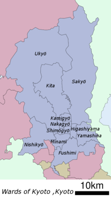
Minami-ku ( Japanese 南 区 , German "southern district") is one of 11 boroughs ( ku ) of Kyōto , Japan .
history
The municipality was established on September 1, 1955, when it was separated from Shimogyō-ku .
geography
Minami-ku is roughly bounded by the Kamo Rivers in the east and Katsura in the west, Hachijō Street and the JR Kyoto Railway Line in the north and the Meishin Highway in the south.

The south of Kyoto, including Minami-ku, is sometimes called rakunan . It is the only side that Kyoto is not surrounded by mountains, which makes it the traditional access area of the city.
Minami-ku is Kyoto's most labor force district. A significant Korean population known as the Zainichi also live here . This is especially true for the district of Higashi-Kujō (East Kujō), the area around Kujō Street from Tōji Station to Kamo.
Attractions
The district is not very well developed for tourism. Minami-ku has relatively few sights, at least by the standards of Kyoto, which otherwise has a lot of temples, shrines and historical places. However, the former Rajōmon , which was the southern entrance to the city, and the temple Tō-ji , where the monk Kūkai taught, are important.
Individual evidence
Web links
- official website (Japanese)
Fushimi-ku | Higashiyama-ku | Kamigyō-ku | Kita-ku | Minami-ku | Nakagyō-ku | Nishikyō-ku | Sakyō-ku | Shimogyō-ku | Ukyō-ku | Yamashina-ku