
Mjøsa
| Mjøsa | ||
|---|---|---|

|
||
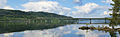
| The Mjøsa lake near Hamar | ||
| Geographical location | Fylker Viken and Innlandet , Norway | |
| Tributaries | Lågen | |
| Drain | Vorma | |
| Islands | Helgøya | |
| Places on the shore | Lillehammer , Gjøvik , Hamar | |
| Data | ||
| Coordinates | 60 ° 40 ′ N , 11 ° 0 ′ E | |
|
||
| Altitude above sea level | 123 moh. | |
| surface | 369 km² | |
| length | 117 km | |
| width | 15 km | |
| scope | 273 km | |
| Maximum depth | 468 m | |
|
particularities |
the largest lake in Norway |
|

The Mjøsa , with an area of 369 square kilometers the largest lake in Norway .
description
The lake is 123 meters above sea level, is 117 kilometers long and up to 449 meters deep (the lake floor is 330 meters below sea level). Its maximum width, which it reaches at Hamar , is 15 kilometers. His largest island, Helgøya, is also located here. 17 rivers flow into the lake, one of which is Gudbrandsdalslågen , which brings the water from Gudbrandsdalen and flows into Lillehammer . At the southern end the Vorma river leaves the lake. The total length of the shore of the lake is 273 kilometers.
The most important towns on the shore are Lillehammer in the north, Gjøvik in the west and Hamar in the east.
The landscape along the lake is mainly used for agriculture and forms one of the most fertile growing areas for grain in Norway.
In the village of Moelv, the lake is crossed by a road bridge on the E6 . The main railway line from Oslo to Trondheim , the Dovrebahn , runs on the east bank of the lake, with stops in Hamar and Lillehammer.
geology
The Gudbrandsdal with the Mjøsa forms the northern part of a chain of rift valleys , the Mediterranean-Mjosen zone .
Water level
The water level of the lake was regulated repeatedly.
- In 1858 a dam wall was built near the town of Eidsvoll to improve navigation on the Vorma River.
- In 1911, the Svanfoss Dam was built further south to generate energy. This increased the water level on the lake by 2.2 meters.
- In 1947 the water level was raised to 2.86 meters above normal.
- Finally, in 1965, there was a final increase in the water level. It is now 3.61 meters higher than it was before 1911.
In the past there had been repeated floods after rain and snowmelt. In 1789, the water in Lake Mjøsa rose 10 meters and caused great damage. 400 houses were washed away, with 68 people losing their lives.
Worth mentioning
The steamship Skibladner ( DS Skibladner ), a paddle steamer from 1856 , operates on the lake .
The poet priest Siegbert Stehmann wrote in the Second World War in 1940 a poem guard at Mjösa .
See also
Web links
Individual evidence
- ↑ og dypeste innsjøer kartverket.no, accessed on February 22, 2020
- ^ Matti Seppälä, The Physical Geography of Fennoscandia, Oxford University Press, 2005, p. 145
Mjøsa with the E6 bridge

Minnesund
