Moldotoo
| Moldotoo | ||
|---|---|---|
|
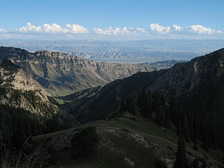
View from the Moldo Pass |
||
| Highest peak | . ( 4185 m ) | |
| location | Naryn ( Kyrgyzstan ) | |
| part of | Tienschan | |
|
|
||
| Coordinates | 41 ° 37 ′ N , 75 ° 19 ′ E | |
| rock | limestone | |
The Moldotoo ( Kyrgyz Молдотоо ) is a mountain range in the Naryn region in Kyrgyzstan .
The Moldotoo is part of the Tienschan mountain system in Central Asia . It runs north of the Naryn lowlands and south of the Songköl lowlands over a length of about 150 km in an east-west direction. The river valleys of Songköl and Kökömeren form the boundary to the east and west. The Moldotoo reaches a maximum height of 4185 m . The mountain range consists mainly of limestone . Mountain heather grows on the lower slopes . Spruce forests and juniper bushes can be found at higher elevations . The Moldo Pass crosses the mountains in a north-south direction at an altitude of 3150 m .
Individual evidence
- ↑ a b c Article Moldotoo in the Great Soviet Encyclopedia (BSE) , 3rd edition 1969–1978 (Russian)

