Mongaguá
| Mongaguá | ||||||||

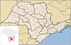
Mongaguá in the Brazilian state of São Paulo |
||||||||
|
|
||||||||
|
||||||||
 São Paulo (center) and Baixada Santista on the coast |
Mongaguá is a municipality on the coast of the Brazilian state of São Paulo . Mongaguá is part of the metropolitan region of Baixada Santista around the port city of Santos, which is about 35 km northeast . The distance to the state capital São Paulo is around 65 km. In 2018, an estimated 55,731 inhabitants lived in the municipality on an area of 143 km², which corresponds to a population density of around 389 people per square kilometer.
Mongaguá has the official status of a spa, an Estância balneária . The economy is determined by tourism. Numerous beaches attract visitors, especially from the capital São Paulo with its more than 10 million people. The community has been developed for tourism since the 1970s and has since developed from a predominantly rural structure to an urban settlement. As tourism grew, so did construction, trade and services.
The area of Monguagá between the Rio Monguagá and Rio Aguapeú was originally inhabited by the Guaraní Indians. From 1532 Portuguese settlers and missionaries began to tour the country, which is known for its water quality and abundance of fish. In 1948 Mongaguá first became an independent district within the municipality of Itanhaém , before it became an independent municipality itself in 1959. There are also two reserves in the municipality , Itaóca and Aguapéu .
Mongaguá has excellent transport connections with São Paulo and the BR-101 national road, which runs along the coast of eastern Brazil for more than 4550 km from Natal in the north to Porto Alegre in the south, also runs through the town. In Mongaguá itself, the streets are symmetrically laid out in a NW-SW scheme. The place is located at the foot of steep mountains overgrown by the Atlantic rainforest, the Mata Atlântica . The municipality consists of about 60% flat land and 40% mountains and hill country.
Web links
Individual evidence
- ↑ a b IBGE to Mongaguá. Retrieved June 2, 2019 .
|
||||
Coordinates: 24 ° 5 ′ S , 46 ° 38 ′ W

