Peruíbe
| Peruíbe | ||
|---|---|---|
|
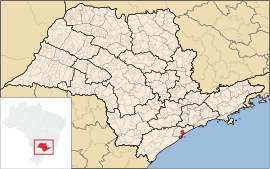
Coordinates: 24 ° 19 ′ S , 47 ° 0 ′ W Peruíbe on the map of São Paulo
|
||
|
Location of the municipality of Peruíbe in the state of São Paulo
|
||
| Basic data | ||
| Country | Brazil | |
| State | São Paulo | |
| City foundation | 1995 | |
| Residents | 57,151 (2008) | |
| City insignia | ||
| Detailed data | ||
| surface | 326 km 2 | |
| Population density | 200 inhabitants / km 2 | |
| Time zone | UTC −3 | |
| Website | ||
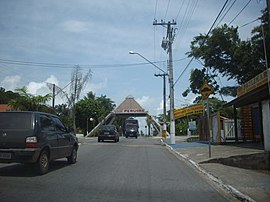
| Entrance to the City (2008) | ||
Peruíbe is a municipality on the coast of the Brazilian state of São Paulo . Peruíbe represents the southwestern end of the metropolitan region of Baixada Santista around the port city of Santos , which is about 80 km northeast . The distance to the state capital São Paulo is around 95 km. The municipality has around 57,151 inhabitants (2008) on an area of 326 km², which corresponds to a population density of 200 people per square kilometer.
Peruíbe has the official status of a spa, an Estância balneária. The economy is determined by tourism. Numerous beaches attract visitors, especially from the state capital São Paulo with its more than 10 million people.
In addition to a rich natural environment, such as beaches, mountains, rivers and waterfalls, the municipality also has archaeological treasures such as Køkkenmøddinger (prehistoric rubbish heaps). There are also ruins from the early days of the Portuguese conquest. In the municipality there is also a reservation of the Nhandhevá , the Guarani people .
Web links
- Official website of the municipality (Portuguese)
- citybrazil.com (Portuguese)
|
||||


