
Monnow Bridge
Coordinates: 51 ° 48 ′ 32 " N , 2 ° 43 ′ 12" W.
| Monnow Bridge Pont Trefynwy |
||
|---|---|---|
 |
||
| use | pedestrian | |
| Crossing of | River Monnow | |
| place | Monmouth (Wales) | |
| construction | Stone arch bridge | |
| completion | Late 13th century | |
| location | ||
|
||

The Monnow Bridge ( Welsh : Pont Trefynwy ) in Monmouth , Wales , is the only one in the United Kingdom preserved medieval fortified river bridge, the gate tower is still standing on the bridge.
It bridges the River Monnow about 500 m above its confluence with the River Wye . The bridge, which is only used by pedestrians today, is a state-protected scheduled monument and listed as Grade I by the monument authority .
Bridge and gate tower in the 13th and 14th centuries
The bridge was built in the late 13th century; there is no verifiable evidence of the traditionally assumed year of construction 1272. The structure replaced an older wooden overpass. Flood protection work in 1988 exposed the remains of the wooden bridge directly beneath the stone structure, and dendrochronological studies showed that the wood came from trees that had been felled between 1123 and 1169. Some sources suggest that the bridge and the nearby church of St Thomas the Martyr were built between supporters of King Henry III during the Battle of Monmouth (1233) . and Earl Richard Marshal's troops were damaged by fire.
The three-arched bridge is made of old-red sandstone , the hexagonal pillars are designed as ice breakers . The gate tower, called Monnow Gate , which gives the bridge its striking and noteworthy appearance, was built at the end of the 13th and beginning of the 14th century, just a few years after the bridge was built. In 1297 , at the request of his nephew Henry Plantagenet , King Edward I raised a wall tax ("murrage") in favor of Monmouth. This allowed the citizens to build city walls and gates for protection and defense. In 1315 the construction was not yet completed or in need of repair, as the previous reign was changed on June 1, 1315. At that time, the bridge was tighter than it is today, as all traffic had to go through only one passage and under a portcullis (the grooves for lowering are still visible). The conspicuously domed machiculis were added at an unknown point in the Middle Ages, possibly towards the end of the fourteenth century.
In the opinion of the local history researcher Keith Kissack, the gate was not suitable for defensive purposes, as the Monnow could easily be crossed upstream. Nevertheless, it was not only used by the Anglo-Norman urban population in attacks by the Welsh from the surrounding areas, but also served as a border to be able to pay tolls on market traders. Customs duties were allowed in the Patent Rolls of 1297 and 1315 and then enshrined in city charter.
Following use and building history
.jpg)
Neither the city of Monmouth nor Monmouth Castle were attacked during the Welsh Independence Uprising under Owain Glyndŵr . The nearby towns of Abergavenny and Grosmont were burned down during this rebellion against the English crown, later known as Glyndŵr Rising . Monmouth suffered from the devastation of its surrounding areas. More than two centuries later, during the English Civil War , the town changed hands several times. In 1645 the bridge was the scene of a small skirmish between loyal "Cavaliers" of Raglan Castle and supporters of Parliament, so-called Roundheads under Colonel Kirle. In 1705 maintenance work was carried out on the bridge. The original fortress wall was replaced with massive walls and the gate tower with wooden extensions was expanded to include a two-storey building that protruded onto the river. The house was rented to a gatekeeper now resident there who took care of the repair and maintenance of the building. Part of the building was still used as a local holding cell, and both the bridge and gate tower were extensively refurbished between 1771 and 1775. The house was no longer used as a residential building before 1804.
The extension was then removed again in 1815 and in 1819 a pedestrian passage through the gate tower was made on the upstream side to calm the traffic situation. Before 1830 the gate tower belonged to the Monmouth Corporation , but was then formally transferred to the Duke of Beaufort in the course of an exchange of ownership. The roof of the gate tower was rebuilt in 1832 with a deeper eaves and four decorative consoles on each side. In 1845 a second pedestrian passage was made in the downstream side of the gate tower. Since then, apart from regular maintenance and repairs, the structure of the building has not been changed. In 1900, ownership passed to Monmouthshire County Council , as can be seen on a brass plaque on the gate tower.
Until the middle of the 19th century, the gate tower was the scene of annual fights, so-called "muntlings", between rival gangs from the upper part of the city, the main part of Monmouth, and gangs from Overmonnow , also called "Cappers' Town", there traditionally the manufacturers of the woolen hats, the Monmouth caps , lived. The clashes took place on May 1st and 29th, during which the young people armed themselves with sticks ("muntles") that were reinforced with stones. These riots were banned in 1858.
In the 20th century

From 1889 to 1902 extensive monument protection work was carried out on the bridge. In order to prevent a possible collapse of the gate tower, two metal bars were inserted halfway up to connect the two fronts of the gate tower. The four round end plates of the two struts are still visible. Work on the arches and pillars of the bridge began in 1892 after it was discovered that erosion in the river bed had washed away the piers. This long-term restoration work was completed with the repair of the outer wall of the gate tower from the mid-1890s to 1897. Gutters and downspouts were added, heavily eroded stone was replaced with blocks made of Old Red sandstone , and the cross-shaped loopholes on the left front of the building were given a symmetrical appearance. In April 1893 the city administration installed the first street lamp on the bridge. In the late 1920s, the upper area was replaced with twin-lamp electric lights. In the 1960s the lamp was completely removed and since 1991 the bridge has been illuminated with floodlights.
The increase in traffic in the 20th century, and the resulting more frequent accidents and traffic congestion on a road that is slightly elevated in the middle of the bridge, which allows poor visibility and only offers narrow access roads, led to increased demands for a bypass the bridge. The structure was first formally recognized as a historic monument in 1923, and proposals for a new road bridge were made around the same time. The A40 trunk road from London to Fishguard on the Atlantic, which was completed in 1965/66, led to considerable traffic relief in Monmouth. A design by the Monmouth County Council to design the city center in 1981 included a new bridge. A serious accident on May 18, 1982, in which a double-decker bus tried to drive into town, led to the bridge being closed for a month during which extensive repairs were carried out.
A feasibility study by the engineering office Ove Arup and Partners in 1999 for a new bridge further away from the Monnow Bridge did not lead to any result. Nevertheless, on March 15, 2004, a new bridge over the Monnow was finally completed for local traffic. The old bridge has now been declared a pedestrian bridge. However, the construction work for the new bridge also led to the demolition of the old cattle market. To celebrate the new millennium, the city administration erected the "Millennium Plinth", a ceramic mosaic, at the entrance to the bridge. The round mosaic on a stone plinth consists of 40 tiles that illustrate over 2000 years of local history.
The image of the bridge is considered a symbol of the city (see the illustration in the comic novel The Interactives ). Monnow Bridge, along with 24 other attractions in the city, is part of the Monmouth Heritage Trail .
photos

Monnow Bridge and Gate Tower, 1915

The Monnow Bridge , engraving after a colored pencil drawing, Thomas Hearne, 1780s

The bridge seen from the east

Looking east through the archway towards the city center

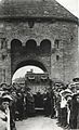
Farmers' market on the pedestrian bridge, 2008

Weir under the Monnow Bridge

Porcelain model, 1970
July 5, 1918: Tank 'Julian' in the War Savings campaign . The tank came by railroad and was moved to Agincourt Square in a move .

The gate tower in the comic novel The Interactives , 2012


.jpg)
Remarks
- ^ A b c John Newman: The Buildings of Wales: Gwent / Monmouthshire . Penguin Books, 2000, ISBN 0-14-071053-1 , p. 402.
- ↑ a b c d e f g h M.LJ Rowlands: Monnow Bridge and Gate . Alan Sutton Publishing, 1994, ISBN 0-7509-0415-1 .
- ^ History of St Thomas the Martyr . Monmouth Parishes. Retrieved December 9, 2011.
- ^ Monnow Bridge . The Monmouth website. Retrieved April 1, 2012.
- ↑ Monmouth Civic Society: Guide to the Monmouth Heritage Blue Plaque Trail no date, p. 4.
- ^ Roy Palmer: The Folklore of (Old) Monmouthshire . Logaston Press, 1998, ISBN 1-873827-40-7 , p. 262.
- ^ William Henry Greene: Jack o 'Kent and the Devil: Stories of a Welsh border hero , p. 5 (accessed April 3, 2012).
- ↑ Wayne Forster and Ove Arup and Partners - New Bridge at Monmouth, Report to Monmouthshire County Council on feasibility and urban impact of new bridge in Monmouth with Ove Arup and Partners, University of Wales Cardiff (1999)
- ↑ Monmouth Town Guide (PDF) Monmouth Town Council. 12 2011. Accessed on April 3, 2012. ( Page no longer available , search in web archives ) Info: The link was automatically marked as defective. Please check the link according to the instructions and then remove this notice.
- ↑ Jason Sacks: Peter Rogers: Faith in British Imagination . Retrieved on March 7, 2012. ( Page no longer available , search in web archives ) Info: The link was automatically marked as defective. Please check the link according to the instructions and then remove this notice.
Web links
- Monnow Bridge , geograph.org.uk
- Monnow Bridge. In: Structurae
- Monnow Bridge In: Europeana .