Monte Balmaceda
| Monte Balmaceda | ||
|---|---|---|
|
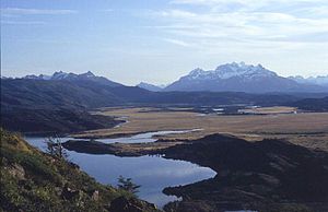
Monte Balmaceda from the northeast, in the foreground Lago del Toro |
||
| height | 2035 m | |
| location | Chile | |
| Mountains | To the | |
| Coordinates | 51 ° 25 ′ 0 ″ S , 73 ° 11 ′ 0 ″ W | |
|
|
||
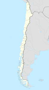
The Monte Balmaceda is a 2035 m high, heavily glaciated mountain in the Región de Magallanes y de la Antártica Chilena in southern Chile .
The mountain stands at the northern end of the Última Esperanza fjord in the Bernardo O'Higgins National Park, 40 kilometers south of the Torres del Paine . In particular the eastern flanks are covered by glaciers, the Balmaceda and the Serrano . The latter feeds on the Lago Serrano the Río Serrano . The closest larger town is in the southeast on the fjord, the capital of the province of Última Esperanza Puerto Natales .
swell
- ↑ - ( Memento of the original from December 3, 2010 in the Internet Archive ) Info: The archive link was inserted automatically and has not yet been checked. Please check the original and archive link according to the instructions and then remove this notice.
- ↑ http://gosouthamerica.about.com/library/blToroSerrano.htm
- ↑ http://www.flyfishingteam.org/reisebericht_rio_serrano.shtml


