
Montecolognola
| Montecolognola | |||
|---|---|---|---|

|
|||
| Panorama of Montecolognola | |||
| Country | Italy | ||
| region | Umbria | ||
| province | Perugia (PG) | ||
| local community | Magione | ||
| Coordinates | 43 ° 9 ' N , 12 ° 12' E | ||
| height | 410 m slm | ||
| Residents | 131 (2001) | ||
| Telephone code | 0575 | CAP | 06063 |
Montecolognola (also Monte Colognola ) is a district ( fraction , Italian frazione ) of Magione in the province of Perugia , Umbria region in Italy .
geography
The place is 1.5 km northwest of the main town Magione and 16 km west of the provincial and regional capital Perugia on a hill between Lake Trasimeno and Magione. The place is 410 m slm and 2001 had 131 inhabitants. In the north the place borders on Torricella and 2.5 km southwest lies Monte del Lago (both places are fractions of Magione).
history
The place originated in the 1250s when the subordinates of the Cavalieri Gerosolimitani from Magione (then Pian di Carpine) bought the area from the Bishop of Perugia and built buildings here to oppose the lords of the Gerosolimitani. On May 17, 1261, Alexander IV asked the city of Perugia to intervene. Thereupon the troops from Perugia completely destroyed the place. The Montecolognola Castle was built in the 1290s, this time with permission from Perugia. The place already had 561 inhabitants in 1410. With permission from Perugia, the defensive walls were reinforced in 1481. In 1643/44 the place was besieged by the Grand Duchy of Tuscany under Ferdinando II. De 'Medici , the damage to the fortifications and houses was not repaired later.
Attractions
- Santissima Annunziata , church and pieve in the center, which was first mentioned in 1361 as Pieve di S. Maria de castro Montis Cholognole . The roof was repaired and restored in 1945 after damage from the Second World War, as was the bell tower. Another restoration took place in 1969. Contains frescoes by Gerardo Dottori, created in 1949.
- Fortifications, built in the late 13th / early 14th century.
- Fortified gate Porta del Castello , double gate and main entrance to the place. The gate was built from 1296.
- Fortification gate Porta Nuova also ( Porta Fiorentina ), today's castle gate ruins.
- Madonna delle Fontanelle , sanctuary approx. 500 m south of the town center. Was built in 1508 and was expanded to include a monastery with a cloister in 1550.
- Santa Lucia , church ruin approx. 1 km northeast of the town center, which was no longer used in the 16th century.
- Images from Montecolognola
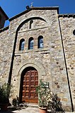
The Church of Santissima Annunziata

The Porta del Castello fortified gate
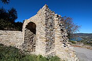
The Porta Nuova fortified gate
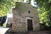
The Sanctuary of the Madonna delle Fontanelle


traffic
- The closest connection point to long-distance traffic is in Torricella, approx. 1 km north. There is a connection to the Raccordo autostradale 6 .
- The nearest train station is also in Torricella. It is on the Terontola- Foligno railway line .
literature
- Touring Club Italiano : Umbria. Milan 1999, ISBN 88-365-2542-3 , p. 187.
Web links
Individual evidence
- ↑ a b c Magione Cultura: Montecolognola
- ^ A b c Italian Touring Club: Umbria.
- ↑ Official website of ISTAT ( Istituto Nazionale di Statistica ) on 2001 population figures in the province of Perugia, accessed on September 13, 2018 (Italian)
- ↑ a b c d e Sandro Tiberini: Montecolognola, so le mura stanno tornando all'antico splendore. Una storia lunga set secoli. In: Umbria24, accessed on September 13, 2018 (Italian)
- ↑ Chiesa della Santissima Annunziata <Montecolognola, Magione> , website Chiese Italiane, Ufficio Nazionale per i beni culturali ecclesiastici e l'edilizia di culto e Servizio Informatico della Conferenza Episcopale Italiana, accessed on September 13, 2018 (Italian)
- ↑ Santuario della Madonna delle Fontanelle <Montecolognola, Magione> , website Chiese Italiane, Ufficio Nazionale per i beni culturali ecclesiastici e l'edilizia di culto e Servizio Informatico della Conferenza Episcopale Italiana, accessed on September 13, 2018 (Italian)
- ↑ Giovanni Riganelli: Chiesa di Santa Lucia , called (Italian) on September 13, 2018