Montes Obarenes
| Montes Obarenes | |
|---|---|
|
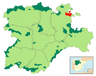
Location of the Montes Obarenes-San Zadornil Natural Park in the Autonomous Region of Castile and León |
|
|
Pico Humión : The highest mountain in the Montes Obarenes |
|
| Highest peak | Pico Humión ( 1435 msnm ) |
| location | Burgos Province ( Spain ) |
| Coordinates | 42 ° 44 ′ N , 3 ° 12 ′ W |
The Montes Obarenes are about 30 km long and an average of about 800 m to 900 m (maximum 1435 m) high mountain range in the comarca Las Merindades in the northeast of the Spanish province of Burgos in the autonomous region of Castile-León and in the west of the autonomous region of La Rioja . The river Ebro forms the northern border of the area in places.
cities and communes
The largest cities in the vicinity of the Montes Obarenes are Miranda de Ebro (Castile) and Haro (La Rioja); other municipalities, some of which have less than 100 inhabitants, are Ameyugo , Bugedo , Cellorigo , Foncea , Galbárruli , Pancorbo , Sajazarra and Villalba de Rioja . The historically significant town of Frías should also be mentioned .
mountains
In addition to the 1435 m high Pico Humión , the imposing, but strongly jagged 912 m high Peña Lengua , which towers over the small town of Cellorigo, should be emphasized .
Natural park
Large parts of the Montes Obarenes mountain range and adjacent smaller mountain ranges belong to the Montes Obarenes-San Zadornil Nature Park, which was established in 2006 .
tourism
Several hiking trails were set up in the last decades of the 20th century. There are numerous small restaurants and hostels in the villages .

