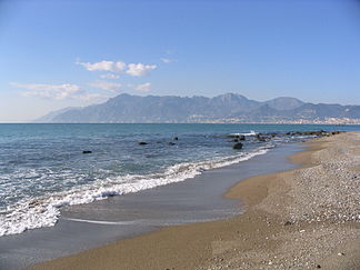
Monti Lattari
| Monti Lattari | ||
|---|---|---|
|
Monti Lattari over the Gulf of Salerno |
||
| Highest peak | Monte San Michele ( 1444 m slm ) | |
| location | Salerno Province , Italy | |
| part of | Southern Sub-Apennines | |
|
|
||
| Coordinates | 40 ° 39 ′ N , 14 ° 30 ′ E | |
The Monti Lattari (German: Milchberge ) are an Italian mountain group with a height of up to 1444 m slm in the province of Salerno and the metropolitan city of Naples in the Campania region . The name Monti Lattari comes from the numerous dairy goats that ring the visitor's attention from afar with the ringing of their bells.
geography
The mountains are surrounded by the towns of Positano , Vico Equense , Gragnano , Pimonte , Amalfi , Tramonti , Sant'Egidio del Monte Albino , Vietri sul Mare and Cava de 'Tirreni . The mountain group includes a nature reserve and belongs to the regional park "Parco regional dei Monti Lattari". When the weather is good, they offer a beautiful panorama over the Gulf of Salerno and the Gulf of Naples . To the north you can see Vesuvius .
Numerous springs spring from the porous rock and have polished the rocks bright. In the past, the energy of the mountain streams was used in numerous water mills ( Valle dei Mulini near Amalfi). As in Amalfi and Atrani, the watercourses are often hidden under the pavement of the street, invisible to visitors, and serve to supply drinking water. In the case of very heavy and long-lasting rainfalls, the otherwise rather leisurely current swells strongly. Under unfavorable circumstances, the force of the incoming water can develop very strong destructive forces and be life-threatening for the residents.
The north side of the mountains is forested and not so steeply sloping, but the south side, which is much more exposed to the sun, is bare in many places and has steep rock walls. The temperature difference between the two sides can be up to 20 degrees Celsius. Due to the process of weathering, on January 4, 2002, there was a huge rock fall on Monte Catello.
history
In the Battle of Mons Lactarius in 552 (or perhaps until early 553) defeated the Byzantine general Narses on behalf of the Emperor Justinian I the last Ostrogothic King Teja .
reachability
With the expansion of the road network, the historical paths within the Monti Lattari have largely lost their former importance. Today they are used as hiking trails, but also by the herds of dairy goats on their way to the pastures. Probably the most famous hiking trail is the Sentiero degli Dei (Path of the Gods), which leads on ancient paths halfway up from Bomerano to Positano and offers fantastic views.
From the train station in the town of Castellammare di Stabia, you can take the cable car directly to Monte Faito (recreational area for Napolitans stressed by the summer heat). A well-developed network of bus routes (SITA) makes it possible to reach almost all residential areas in the Monti Lattari. The important coastal towns can be reached by ferry from Naples and Salerno, and on the north side by train. Long and strenuous stairways that lead to higher and more remote parts of the town, which are (still) car-free, are typical. The peaks of the Monti Lattari are mainly accessible by hiking trails.
summit
| Name of the mountain | Height (meter slm) |
|---|---|
| Monte San Michele | 1444 m |
| Monte Cerreto | 1316 m |
| Monte Finestra | 1138 m |
| Monte Faito | 1131 m |
| Monte Sant'Angelo di Cava | 1130 m |
| Monte Albino | 1075 m |
| Monte dell'Avvocata | 1014 m |
| Monte San Costanzo | 497 m |


