Motzenhofen
|
Motzenhofen
Hollenbach municipality
Coordinates: 48 ° 29 '22 " N , 11 ° 5' 34" E
|
|
|---|---|
| Residents : | 495 (December 31, 2018) |
| Incorporation : | 1st January 1971 |
| Postal code : | 86568 |
| Area code : | 08257 |
|
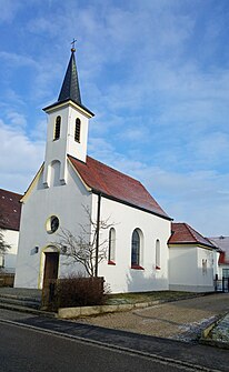
Church of the Visitation of the Virgin Mary
|
|
Motzenhofen is a village and district of Hollenbach in the district of Aichach-Friedberg , which belongs to the administrative district of Swabia in Bavaria .
geography
Motzenhofen is located in the Danube-Isar hill country and thus in the Lower Bavarian hill country, which belongs to the Alpine foothills , one of the main natural spatial units in Germany .
Motzenhofen is located directly to the east, bordering the main town of Hollenbach, and is almost fused with it.
The Krebsbach , which comes from the west and flows into the Paar at Walchshofen, flows through Motzenhofen . To the east of Motzenhofen, the Silberbrünchen, which originated in the Bernbacherwald south of Motzenhofen, flows from the right into the Krebsbach.
The state road St 2047 from Rain am Lech to Aichach runs from northwest to southeast through Motzenhofen . In Motzenhofen, this crosses the district road AIC 4 from Haunswies , which runs south-west and north-east along the Krebsbachtal , which joins the district road AIC 1 after Motzenhofen .
history
Ecclesiastically Motzenhofen belongs to the Catholic parish Saint Peter and Paul in Hollenbach.
Motzenhofen belonged to the district of Aichach as an independent municipality until January 1, 1971 and was then incorporated into the municipality of Hollenbach as part of the regional reform in Bavaria .
Architectural monuments
See also: List of architectural monuments in Motzenhofen
- Catholic branch church of the Visitation of the Virgin Mary
Web links
- Motzenhofen in the location database of the Bayerische Landesbibliothek Online . Bavarian State Library
- Hollenbach municipality

